-
BLM AIM TerrADat TerrestrialAIM Point v1

מאז 2011, המשרד לניהול קרקעות (BLM) אוסף מידע מהשטח כדי לקבל תמונה על מצב הקרקע באמצעות אסטרטגיית המלאי, ההערכה והניטור (AIM). עד היום נאספו יותר מ-6,000 נתוני שטח של AIM באזורים שבשליטת BLM. ארכיון הנתונים של BLM AIM הוא … blm ecosystems hydrology range soil table -
NLCD 2019: USGS National Land Cover Database, מהדורה 2019
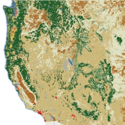
NLCD (מסד נתונים לאומי של כיסוי הקרקע) הוא מסד נתונים של כיסוי הקרקע ברזולוציה של 30 מטרים שמבוסס על Landsat וכולל 8 תקופות (2001, 2004, 2006, 2008, 2011, 2013, 2016 ו-2019). אפשר גם לראות כאן את התקופה התשיעית של 2021. התמונות מסתמכות על שכבת הנתונים של חוסר החדירות באזורים עירוניים… blm landcover landuse-landcover mrlc nlcd usgs -
NLCD 2021: USGS National Land Cover Database, 2021 release
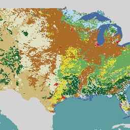
בשיתוף עם כמה סוכנויות פדרליות, ה-USGS (שירות הסקר הגיאולוגי של ארה"ב) פיתח והשיק שבעה מוצרים של National Land Cover Database (מאגר מידע לאומי לכיסוי קרקע): NLCD 1992, 2001, 2006, 2011, 2016, 2019 ו-2021. החל מגרסת 2016, מוצרי כיסוי הקרקע נוצרו במרווחי זמן של שנתיים עד שלוש… blm landcover landuse-landcover mrlc nlcd usgs
Datasets tagged blm in Earth Engine
[null,null,[],[],["The Bureau of Land Management (BLM) has collected over 6,000 terrestrial field plots since 2011 to assess land health through its AIM strategy. The USGS, in collaboration with federal agencies, has created the National Land Cover Database (NLCD), available for multiple epochs (2001-2021), updating land cover data. The NLCD utilizes 30-m Landsat-based imagery and is available from multiple years with two to three year intervals from 2016 onward.\n"]]