-
כיסוי הקרקע של צפון אמריקה ברזולוציה של 30 מטר, 2020
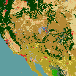
מערך הנתונים של כיסוי הקרקע בצפון אמריקה משנת 2020 ברזולוציה של 30 מטר נוצר כחלק ממערכת המעקב אחר שינויים בכיסוי הקרקע בצפון אמריקה (NALCMS), שיתוף פעולה משולש בין Natural Resources Canada, United States Geological Survey ושלושה ארגונים מקסיקניים, כולל National Institute of Statistics and Geography… landcover landsat landuse-landcover nlcd reflectance -
NLCD 2019: USGS National Land Cover Database, 2019 release
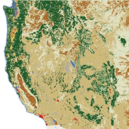
NLCD (המאגר הלאומי לכיסוי קרקע) הוא מאגר נתונים של כיסוי קרקע שמבוסס על Landsat, עם רזולוציה של 30 מטר, שמתפרס על פני 8 תקופות (2001, 2004, 2006, 2008, 2011, 2013, 2016 ו-2019). אפשר גם לראות כאן את התקופה התשיעית של 2021. התמונות מסתמכות על שכבת הנתונים של חוסר החדירות באזורים עירוניים… blm landcover landuse-landcover mrlc nlcd usgs -
NLCD 2021: USGS National Land Cover Database, 2021 release
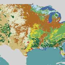
בשיתוף עם כמה סוכנויות פדרליות, ה-USGS (שירות הסקר הגיאולוגי של ארה"ב) פיתח והשיק שבעה מוצרים של National Land Cover Database (מאגר נתונים לאומי של כיסוי קרקע, NLCD): NLCD 1992, 2001, 2006, 2011, 2016, 2019 ו-2021. החל מגרסת 2016, מוצרים של כיסוי קרקע נוצרו במרווחי זמן של שנתיים עד שלוש… blm landcover landuse-landcover mrlc nlcd usgs -
RCMAP Rangeland Component Timeseries (1985-2023), v06

'מערך הנתונים RCMAP (הערכה ותחזית של ניטור מצב שטחי מרעה) מכמת את אחוז הכיסוי של רכיבי שטחי מרעה במערב צפון אמריקה באמצעות תמונות Landsat משנת 1985 עד 2023. חבילת המוצרים של RCMAP מורכבת מעשרה רכיבים חלקיים: annual herbaceous, bare ground, herbaceous, litter, non-sagebrush shrub, perennial herbaceous, sagebrush, … climate-change disturbance landsat-derived landuse-landcover nlcd rangeland -
RCMAP Rangeland Trends Year for Component Timeseries (1985-2023), v06

האוסף הזה כולל מוצרים שנתיים של RCMAP משנת 1985 עד 2023. מערך הנתונים RCMAP (הערכה ותחזית של ניטור מצב שטחי מרעה) מכמת את אחוז הכיסוי של רכיבי שטחי מרעה במערב צפון אמריקה באמצעות תמונות Landsat משנת 1985 עד 2023. חבילת המוצרים של RCMAP מורכבת מעשרה רכיבים חלקיים: שנתי … climate-change disturbance landsat-derived landuse-landcover nlcd rangeland -
RCMAP Rangeland Trends for Component Timeseries (1985-2023), v06

מערך הנתונים RCMAP (הערכה ותחזית של ניטור מצב שטחי מרעה) מכמת את אחוז הכיסוי של רכיבי שטחי מרעה במערב צפון אמריקה באמצעות תמונות Landsat משנת 1985 עד 2023. חבילת המוצרים של RCMAP מורכבת מעשרה רכיבים חלקיים: annual herbaceous, bare ground, herbaceous, litter, non-sagebrush shrub, perennial herbaceous, sagebrush, … climate-change disturbance landsat-derived landuse-landcover nlcd rangeland
Datasets tagged nlcd in Earth Engine
[null,null,[],[],[]]