-
NEON キャノピー高さモデル(CHM)
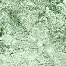
裸地の上のキャノピーの高さ(キャノピー高さモデル、CHM)。CHM は NEON LiDAR ポイントクラウドから導出され、LiDAR 調査の空間ドメイン全体でキャノピーの高さの推定値の連続面を作成することで生成されます。… airborne canopy forest forest-biomass highres lidar -
NEON キャノピー窒素含有量(CNC)

NEON Imaging Spectrometer(NIS)から導出された L1 地表方向反射率で予測され、NEON 植物葉化学観測で校正された、モデル化されたキャノピー窒素濃度。バンドには、1)キャノピー窒素パーセント、2)キャノピー窒素モデルの不確実性、3)針葉樹モデルと非針葉樹モデルの分類結果が含まれます。 airborne canopy forest highres hyperspectral neon -
NEON 数値標高モデル(DEM)
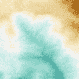
NEON LiDAR データから導出された地表(DSM)と地形(DTM)のデジタル モデル。DSM: 地表の特性(植生と人工構造物を含む地形情報)。DTM: 裸地の標高(植生と人工構造物を取り除いた地形情報)。画像は海抜メートルで示されています。 airborne dem elevation-topography forest highres lidar -
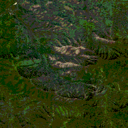
NEON RGB カメラ画像
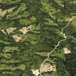
最近傍法によるリサンプリングを使用して、固定された均一な空間グリッドにモザイク処理して出力された、高解像度の赤、緑、青(RGB)の正射補正カメラ画像。空間解像度は 0.1 m です。デジタル カメラは、NEON Airborne Observation Platform(AOP)の一連の機器の一部であり、… airborne forest highres neon neon-prod-earthengine orthophoto -
NEON 地表双方向反射率

NEON AOP 地表双方向反射率は、426 バンドを含むハイパースペクトル VSWIR(可視光から短波赤外線)データ プロダクトで、波長は ~380 nm から 2510 nm です。反射率は 10,000 倍にスケーリングされます。1340 ~ 1445 nm と 1790 ~ 1955 nm の波長は … airborne forest highres hyperspectral neon neon-prod-earthengine -
NEON 地表方向反射率
NEON AOP 地表方向反射率は、426 バンドを含むハイパースペクトル VSWIR(可視光から短波赤外線)データ プロダクトで、波長は ~380 nm から 2510 nm です。反射率は 10,000 倍にスケーリングされます。1340 ~ 1445 nm と 1790 ~ 1955 nm の波長は … airborne forest hyperspectral neon neon-prod-earthengine publisher-dataset
Datasets tagged neon in Earth Engine
[null,null,[],[],["NEON data includes the Canopy Height Model (CHM), which estimates canopy height from LiDAR. Digital Elevation Models (DEM) provide surface and terrain information from LiDAR. Directional and Bidirectional Surface Reflectance data offer hyperspectral information across 426 bands, excluding water vapor absorption bands. RGB Camera Imagery provides high-resolution, orthorectified images at 0.1m resolution, collected using an airborne platform. All the data includes information about the forest.\n"]]