-
Gambar Tingkat Keparahan Luka Bakar Monitoring Trends in Burn Severity (MTBS)
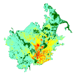
Mosaik tingkat keparahan kebakaran terdiri dari gambar raster tematik kelas tingkat keparahan kebakaran MTBS untuk semua kebakaran MTBS yang saat ini telah selesai di Amerika Serikat kontinental, Alaska, Hawaii, dan Puerto Riko. Gambar tingkat keparahan kebakaran yang disusun dalam mozaik dikumpulkan setiap tahun untuk setiap tahun oleh Negara Bagian AS dan … eros fire forest gtac landcover landsat-derived -
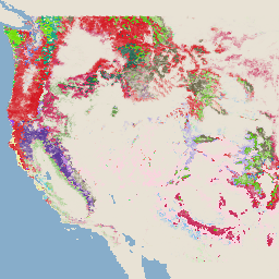
USFS Landscape Change Monitoring System v2025-11 (CONUS dan OCONUS)

Produk ini adalah bagian dari rangkaian data Sistem Pemantauan Perubahan Lanskap (LCMS). Peta ini menampilkan perubahan yang dimodelkan LCMS, kelas penggunaan lahan, dan/atau kelas tutupan lahan untuk setiap tahun dan mencakup Amerika Serikat Kontinental (CONUS) serta area di luar CONUS (OCONUS) termasuk Alaska (AK), Puerto … change-detection forest gtac gtac-data-publish landcover landuse -
USFS Tree Canopy Cover v2025-6 (CONUS dan OCONUS)

Rangkaian data Tree Canopy Cover (TCC), yang diproduksi oleh United States Department of Agriculture, Forest Service (USFS), adalah output peta berbasis penginderaan jauh tahunan yang mencakup periode 1985-2025. Data ini mendukung project National Land Cover Database (NLCD), yang dikelola oleh US Geological Survey … forest gtac gtac-data-publish landuse-landcover publisher-dataset redcastle-resources -
USFS TreeMap v2016 (Amerika Serikat Daratan)

Produk ini adalah bagian dari rangkaian data TreeMap. Data ini memberikan informasi spasial terperinci tentang karakteristik hutan, termasuk jumlah pohon hidup dan mati, biomassa, dan karbon di seluruh kawasan hutan di benua Amerika Serikat pada tahun 2016. TreeMap v2016 berisi satu gambar, … biomass carbon climate-change conus forest forest-biomass -
USFS TreeMap v2020
Produk ini adalah bagian dari rangkaian data TreeMap. Data ini memberikan informasi spasial mendetail tentang karakteristik hutan, termasuk jumlah pohon hidup dan mati, biomassa, dan karbon di seluruh kawasan hutan di Amerika Serikat pada tahun 2020. TreeMap v2020 berisi 22 band 30 x 30 m … aboveground biomass carbon climate-change conus forest -
USFS TreeMap v2022

Produk ini adalah bagian dari rangkaian data TreeMap. Data ini memberikan informasi spasial terperinci tentang karakteristik hutan, termasuk jumlah pohon hidup dan mati, biomassa, dan karbon di seluruh kawasan hutan di Amerika Serikat pada tahun 2022. TreeMap v2022 berisi 22 band 30 x 30 m … aboveground biomass carbon climate-change conus forest
Datasets tagged redcastle-resources in Earth Engine
[null,null,[],[],[]]