-
Dostępność miast 2015

Ta globalna mapa dostępności przedstawia czas podróży lądowej do najbliższego gęsto zaludnionego obszaru dla wszystkich obszarów między 85 stopniem szerokości geograficznej północnej a 60 stopniem szerokości geograficznej południowej w nominalnym roku 2015. Obszary o dużej gęstości zaludnienia to obszary ciągłe,na których na kilometr kwadratowy przypada co najmniej 1500 mieszkańców lub… accessibility jrc map oxford population twente -
Dostępność opieki zdrowotnej w 2019 r.
Ta globalna mapa dostępności przedstawia czas dojazdu drogą lądową (w minutach) do najbliższego szpitala lub kliniki we wszystkich obszarach między 85 stopniem szerokości geograficznej północnej a 60 stopniem szerokości geograficznej południowej w nominalnym roku 2019. Obejmuje on również czas podróży „pieszej”, w której wykorzystywane są wyłącznie niemotorowe środki transportu. Wysoka… accessibility jrc map oxford population twente -
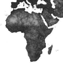
Global Friction Surface 2019
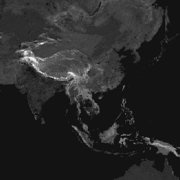
Ta globalna powierzchnia tarcia zawiera informacje o szybkości podróżowania po lądzie dla wszystkich pikseli lądowych między 85 stopniem szerokości geograficznej północnej a 60 stopniem szerokości geograficznej południowej w nominalnym roku 2019. Obejmuje też prędkość podróży „tylko pieszo”, czyli przy użyciu wyłącznie niemotorowych środków transportu. Ta mapa powstała w wyniku współpracy między … accessibility jrc map oxford population twente
Datasets tagged twente in Earth Engine
[null,null,[],[],[]]