-
حدود المناطق المحروقة في إطار برنامج "مراقبة المؤشرات في شدة الحريق" (MTBS)

تحتوي مجموعة بيانات حدود المناطق المحروقة في "مراقبة المؤشرات في شدة الحريق" (MTBS) على مضلّعات المساحات المحروقة لجميع الحرائق التي تم إخمادها حاليًا في الولايات المتحدة القارية وألاسكا وهاواي وبورتوريكو. يشير الاختصار NBR إلى "نسبة الاحتراق العادية"، بينما يشير مصطلح dNBR إلى … eros fire gtac mtbs table usda -
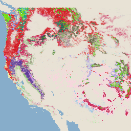
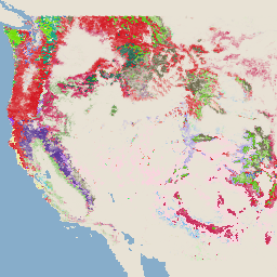
صور درجة خطورة الحريق في إطار برنامج "مراقبة مؤشرات درجة خطورة الحريق" (MTBS)

تتألف صور الفسيفساء لدرجة خطورة الحريق من صور نقطية موضوعية لفئات درجة خطورة الحريق في إطار برنامج "مراقبة المؤشرات في شدة الحريق" (MTBS) لجميع الحرائق التي تم إخمادها حاليًا في الولايات المتحدة القارية وألاسكا وهاواي وبورتوريكو. يتم تجميع صور درجة خطورة الحريق المجمّعة سنويًا لكل عام حسب ولاية الولايات المتحدة و… eros fire forest gtac landcover landsat-derived -
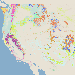
نظام مراقبة التغيّرات في المناظر الطبيعية التابع لهيئة الغابات في الولايات المتحدة، الإصدار 2025-11 (الولايات المتحدة القارية والمناطق خارجها)

هذا المنتج جزء من مجموعة بيانات نظام مراقبة التغيّرات في المناظر الطبيعية (LCMS). يعرض هذا المنتج التغيّرات التي تم وضع نموذج لها في نظام مراقبة التغيّرات في المناظر الطبيعية (LCMS) والغطاء الأرضي و/أو فئات استخدام الأراضي لكل عام، ويشمل الولايات المتحدة القارية (CONUS) والمناطق خارجها (OCONUS)، بما في ذلك ألاسكا (AK) وبورتوريكو … change-detection forest gtac landcover landuse landuse-landcover -
الغطاء الشجري التابع لهيئة الغابات في الولايات المتحدة، الإصدار 2023-5 (الولايات المتحدة القارية والمناطق خارجها)
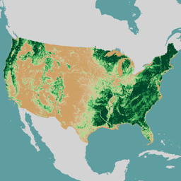
نظرة عامة تتألف مجموعة بيانات الغطاء الشجري (TCC) التي أنتجتها هيئة الغابات في وزارة الزراعة الأمريكية (USFS) من نواتج الخرائط السنوية المستندة إلى الاستشعار عن بُعد والتي تغطي الفترة من 1985 إلى 2023. تساهم هذه البيانات في مشروع "قاعدة البيانات الوطنية للغطاء الأرضي" (NLCD) الذي تديره هيئة المسح الجيولوجي الأمريكية … forest gtac landuse-landcover redcastle-resources usda usfs -
خريطة الأشجار التابعة لهيئة الغابات في الولايات المتحدة، الإصدار 2016 (الولايات المتحدة القارية)
هذا المنتج جزء من مجموعة بيانات خريطة الأشجار. يقدّم هذا المنتج معلومات مكانية مفصّلة عن خصائص الغابات، بما في ذلك عدد الأشجار الحية والميتة والكتلة الحيوية والكربون في جميع المساحات الحرجية في الولايات المتحدة القارية في عام 2016. يحتوي الإصدار 2016 من خريطة الأشجار على صورة واحدة، وهي … biomass carbon climate-change conus forest forest-biomass -
خريطة الأشجار التابعة لهيئة الغابات في الولايات المتحدة، الإصدار 2020
هذا المنتج جزء من مجموعة بيانات خريطة الأشجار. يقدّم هذا المنتج معلومات مكانية مفصّلة عن خصائص الغابات، بما في ذلك عدد الأشجار الحية والميتة والكتلة الحيوية والكربون في جميع المساحات الحرجية في الولايات المتحدة في عام 2020. يحتوي الإصدار 2020 من خريطة الأشجار على صورة متعددة النطاقات (22 نطاقًا) بدقة 30 × 30 مترًا … aboveground biomass carbon climate-change conus forest -
خريطة الأشجار التابعة لهيئة الغابات في الولايات المتحدة، الإصدار 2022
هذا المنتج جزء من مجموعة بيانات خريطة الأشجار. يقدّم هذا المنتج معلومات مكانية مفصّلة عن خصائص الغابات، بما في ذلك عدد الأشجار الحية والميتة والكتلة الحيوية والكربون في جميع المساحات الحرجية في الولايات المتحدة في عام 2022. يحتوي الإصدار 2022 من خريطة الأشجار على صورة متعددة النطاقات (22 نطاقًا) بدقة 30 × 30 مترًا … aboveground biomass carbon climate-change conus forest
Datasets tagged usfs in Earth Engine
[null,null,[],[],[]]