مرزهای منطقه سوخته MTBS 
مجموعه دادههای مرزهای مناطق سوخته «روندهای پایش شدت سوختگی» (MTBS) شامل چندضلعیهای وسعت مناطق سوخته شده در تمام آتشسوزیهای MTBS که در حال حاضر برای ایالات متحده، آلاسکا، هاوایی و پورتوریکو تکمیل شدهاند، میباشد. در زیر NBR مخفف «نسبت سوختگی نرمالشده» است، در حالی که dNBR مخفف ... میز تحریر اروس فایر GTAC مدل MTBS ساخت آمریکا روندهای نظارت بر شدت سوختگی (MTBS) تصاویر شدت سوختگی 
موزاییکهای شدت سوختگی شامل تصاویر رستری موضوعی از کلاسهای شدت سوختگی MTBS برای همه آتشسوزیهای MTBS که در حال حاضر برای ایالات متحده، آلاسکا، هاوایی و پورتوریکو تکمیل شدهاند، میباشد. تصاویر شدت سوختگی موزاییکی شده سالانه توسط ایالت متحده و ... گردآوری میشوند. آتشسوزی اروس ، جنگل جیتیسی، پوشش زمین ، مشتقشده از لندست سیستم پایش تغییرات چشمانداز USFS نسخه 2025-11 (CONUS و OCONUS) 
این محصول بخشی از مجموعه دادههای سیستم پایش تغییرات چشمانداز (LCMS) است. این مجموعه، تغییرات مدلسازیشده توسط LCMS، پوشش زمین و/یا کلاسهای کاربری زمین را برای هر سال نشان میدهد و مناطق مرزی ایالات متحده (CONUS) و همچنین مناطق خارج از CONUS (OCONUS) از جمله آلاسکا (AK)، پورتو ... را پوشش میدهد. تشخیص تغییر، جنگل gtac، پوشش زمین، کاربری زمین ، کاربری زمین، پوشش زمین پوشش سایبان درختی USFS نسخه 2023-5 (CONUS و OCONUS) 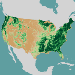
مرور کلی مجموعه دادههای پوشش تاجی درختان (TCC)، که توسط وزارت کشاورزی ایالات متحده، خدمات جنگلداری (USFS) تولید شده است، خروجیهای نقشه سالانه مبتنی بر سنجش از دور هستند که از سال ۱۹۸۵ تا ۲۰۲۳ را در بر میگیرند. این دادهها از پروژه پایگاه داده ملی پوشش اراضی (NLCD) پشتیبانی میکنند که توسط سازمان زمینشناسی ایالات متحده مدیریت میشود... جنگل GTAC، کاربری اراضی، پوشش زمین ، منابع ردکسل، وزارت کشاورزی ایالات متحده، USFS نقشه درختی USFS نسخه ۲۰۱۶ (ایالات متحده آمریکا) 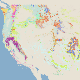
این محصول بخشی از مجموعه دادههای TreeMap است. این مجموعه اطلاعات مکانی دقیقی در مورد ویژگیهای جنگل از جمله تعداد درختان زنده و مرده، زیستتوده و کربن در کل وسعت جنگلی ایالات متحده آمریکا در سال ۲۰۱۶ ارائه میدهد. TreeMap نسخه ۲۰۱۶ شامل یک تصویر، یک ... زیست توده کربن ، تغییرات اقلیمی، جنگل مخروطی ، زیست توده جنگلی نقشه درختی USFS نسخه ۲۰۲۰ 
این محصول بخشی از مجموعه دادههای TreeMap است. این مجموعه اطلاعات مکانی دقیقی در مورد ویژگیهای جنگل از جمله تعداد درختان زنده و مرده، زیست توده و کربن در کل وسعت جنگلی ایالات متحده در سال ۲۰۲۰ ارائه میدهد. TreeMap نسخه ۲۰۲۰ شامل ۲۲ باند ۳۰ در ۳۰ متر است… زیست توده روی زمین ، کربن ، تغییرات اقلیمی ، جنگل مخروطی نقشه درختی USFS نسخه ۲۰۲۲ 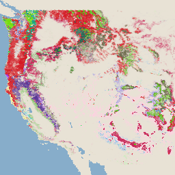
این محصول بخشی از مجموعه دادههای TreeMap است. این مجموعه اطلاعات مکانی دقیقی در مورد ویژگیهای جنگل از جمله تعداد درختان زنده و مرده، زیست توده و کربن در کل وسعت جنگلی ایالات متحده در سال ۲۰۲۲ ارائه میدهد. TreeMap نسخه ۲۰۲۲ شامل ۲۲ باند ۳۰ در ۳۰ متر است… زیست توده روی زمین ، کربن ، تغییرات اقلیمی ، جنگل مخروطی
Datasets tagged usfs in Earth Engine
[null,null,[],[],[]]