-
ขอบเขตพื้นที่ถูกเพลิงไหม้ของ MTBS

ชุดข้อมูลขอบเขตพื้นที่ถูกเพลิงไหม้ของ MTBS (Monitoring Trends in Burn Severity) ประกอบด้วยรูปหลายเหลี่ยมขอบเขตของพื้นที่ถูกเพลิงไหม้จากไฟไหม้ MTBS ทั้งหมดที่เกิดขึ้นในทวีปอเมริกาเหนือ อะแลสกา ฮาวาย และเปอร์โตริโก ซึ่งเกิดขึ้นแล้วในปัจจุบัน โดย NBR ด้านล่างย่อมาจาก "Normalized Burn Ratio" ส่วน dNBR ย่อมาจาก … eros fire gtac mtbs table usda -
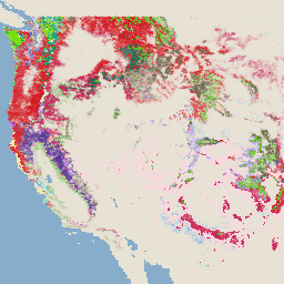
รูปภาพระดับความรุนแรงของไฟไหม้ของ MTBS (Monitoring Trends in Burn Severity)

ภาพโมเสกแสดงระดับความรุนแรงของไฟไหม้ประกอบด้วยรูปภาพแรสเตอร์เชิงธีมของคลาสระดับความรุนแรงของไฟไหม้ MTBS สำหรับไฟไหม้ MTBS ทั้งหมดที่เกิดขึ้นในทวีปอเมริกาเหนือ อะแลสกา ฮาวาย และเปอร์โตริโก ซึ่งเกิดขึ้นแล้วในปัจจุบัน ภาพโมเสกแสดงระดับความรุนแรงของไฟไหม้จะรวบรวมเป็นรายปีสำหรับแต่ละปีโดยรัฐของสหรัฐอเมริกาและ … eros fire forest gtac landcover landsat-derived -
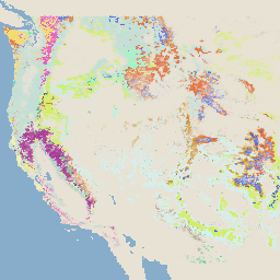
ระบบการตรวจสอบการเปลี่ยนแปลงของภูมิทัศน์ v2025-11 ของ USFS (CONUS และ OCONUS)

ผลิตภัณฑ์นี้เป็นส่วนหนึ่งของชุดข้อมูลระบบการตรวจสอบการเปลี่ยนแปลงของภูมิทัศน์ (LCMS) โดยจะแสดงการเปลี่ยนแปลงที่จำลองโดย LCMS, การปกคลุมของพื้นดิน และ/หรือคลาสการใช้ที่ดินสำหรับแต่ละปี และครอบคลุมสหรัฐอเมริกาที่อยู่ติดกัน (CONUS) รวมถึงพื้นที่นอก CONUS (OCONUS) ซึ่งรวมถึงอะแลสกา (AK), เปอร์โต … change-detection forest gtac landcover landuse landuse-landcover -
พื้นที่ที่ร่มไม้ครอบคลุม v2023-5 ของ USFS (CONUS และ OCONUS)
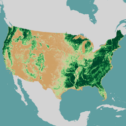
ภาพรวม ชุดข้อมูลพื้นที่ที่ร่มไม้ครอบคลุม (TCC) ซึ่งผลิตโดยกรมป่าไม้ (USFS) ของกระทรวงเกษตรแห่งสหรัฐอเมริกาเป็นผลลัพธ์ของแผนที่ที่อิงตามการรับรู้จากระยะไกลรายปีตั้งแต่ปี 1985-2023 ข้อมูลเหล่านี้สนับสนุนโปรเจ็กต์ฐานข้อมูลการปกคลุมของพื้นดินแห่งชาติ (NLCD) ซึ่งจัดการโดยกรมธรณีวิทยาสหรัฐอเมริกา … forest gtac landuse-landcover redcastle-resources usda usfs -
TreeMap v2016 ของ USFS (สหรัฐอเมริกาที่อยู่ติดกัน)
ผลิตภัณฑ์นี้เป็นส่วนหนึ่งของชุดข้อมูล TreeMap โดยจะให้ข้อมูลเชิงพื้นที่โดยละเอียดเกี่ยวกับลักษณะของป่า ซึ่งรวมถึงจำนวนต้นไม้ที่ยังมีชีวิตและตายแล้ว ชีวมวล และคาร์บอนทั่วทั้งพื้นที่ป่าของทวีปอเมริกาเหนือในปี 2016 TreeMap v2016 มีรูปภาพ 1 รูป ซึ่งเป็น … biomass carbon climate-change conus forest forest-biomass -
TreeMap v2020 ของ USFS
ผลิตภัณฑ์นี้เป็นส่วนหนึ่งของชุดข้อมูล TreeMap โดยจะให้ข้อมูลเชิงพื้นที่โดยละเอียดเกี่ยวกับลักษณะของป่า ซึ่งรวมถึงจำนวนต้นไม้ที่ยังมีชีวิตและตายแล้ว ชีวมวล และคาร์บอนทั่วทั้งพื้นที่ป่าของสหรัฐอเมริกาในปี 2020 TreeMap v2020 มี 22 แบนด์ ขนาด 30 x 30 ม. … aboveground biomass carbon climate-change conus forest -
TreeMap v2022 ของ USFS

ผลิตภัณฑ์นี้เป็นส่วนหนึ่งของชุดข้อมูล TreeMap โดยจะให้ข้อมูลเชิงพื้นที่โดยละเอียดเกี่ยวกับลักษณะของป่า ซึ่งรวมถึงจำนวนต้นไม้ที่ยังมีชีวิตและตายแล้ว ชีวมวล และคาร์บอนทั่วทั้งพื้นที่ป่าของสหรัฐอเมริกาในปี 2022 TreeMap v2022 มี 22 แบนด์ ขนาด 30 x 30 ม. … aboveground biomass carbon climate-change conus forest
Datasets tagged usfs in Earth Engine
[null,null,[],[],[]]