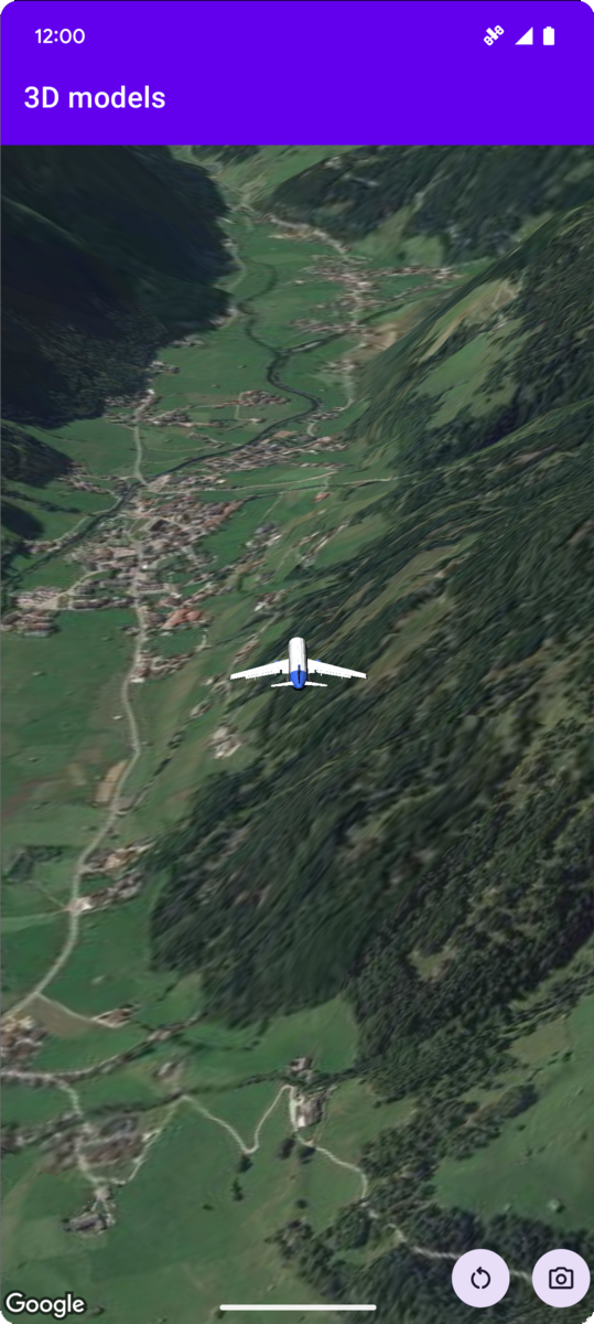
Einer Karte ein 3D‑Modell hinzufügen
Mit Sammlungen den Überblick behalten
Sie können Inhalte basierend auf Ihren Einstellungen speichern und kategorisieren.
Plattform auswählen:
Android
iOS
JavaScript
Das folgende Codebeispiel zeigt, wie Sie ein 3D-Modell hinzufügen und es im 3D-Raum positionieren, indem Sie die Methode addModel
aufrufen. Wenn Sie dieses Codebeispiel verwenden möchten, folgen Sie der Anleitung unter Einrichtung und 3D-Karte in Ihre App einfügen, um Ihr Android Studio-Projekt mit einer einfachen 3D-Karte einzurichten. Fügen Sie dann der Datei MainActivity.kt
den folgenden Code hinzu:
// Add imports and define constants
import com.google.android.gms.maps3d.model.latLngAltitude
val PLANE_URL = "https://storage.googleapis.com/gmp-maps-demos/p3d-map/assets/Airplane.glb"
val PLANE_SCALE = 0.05
// Add to the onMap3DViewReady method, after the googleMap3D object has been initialized
googleMap3D.setCamera(
camera {
center = latLngAltitude {
latitude = 47.133971
longitude = 11.333161
altitude = 2200.0
}
heading = 221.0
tilt = 65.0
range = 1_200.0
}
)
googleMap3D.addModel(
modelOptions {
id = "plane_model"
position = latLngAltitude {
latitude = 47.133971
longitude = 11.333161
altitude = 2200.0
}
altitudeMode = AltitudeMode.ABSOLUTE
orientation = orientation {
heading = 41.5
tilt = -90.0
roll = 0.0
}
url = PLANE_URL
scale = vector3D {
x = PLANE_SCALE
y = PLANE_SCALE
z = PLANE_SCALE
}
}
)
Sofern nicht anders angegeben, sind die Inhalte dieser Seite unter der Creative Commons Attribution 4.0 License und Codebeispiele unter der Apache 2.0 License lizenziert. Weitere Informationen finden Sie in den Websiterichtlinien von Google Developers. Java ist eine eingetragene Marke von Oracle und/oder seinen Partnern.
Zuletzt aktualisiert: 2025-08-31 (UTC).
[null,null,["Zuletzt aktualisiert: 2025-08-31 (UTC)."],[],[],null,["# Add a 3D model to a map\n\nSelect platform: [Android](/maps/documentation/maps-3d/android-sdk/add-3d-models \"View this page for the Android platform docs.\") [iOS](/maps/documentation/maps-3d/ios-sdk/add-3d-models \"View this page for the iOS platform docs.\") [JavaScript](/maps/documentation/javascript/3d/models \"View this page for the JavaScript platform docs.\")\n\n\u003cbr /\u003e\n\n| This product or feature is Experimental (pre-GA). Pre-GA products and features might have limited support, and changes to pre-GA products and features might not be compatible with other pre-GA versions. Pre-GA Offerings are covered by the [Google\n| Maps Platform Service Specific Terms](https://cloud.google.com/maps-platform/terms/maps-service-terms). For more information, see the [launch stage descriptions](/maps/launch-stages).\n\n\nThe following code sample\ndemonstrates how to add a 3D model and position it in 3D space by calling the\n[`addModel`](/maps/documentation/maps-3d/android-sdk/reference/com/google/android/gms/maps3d/GoogleMap3D#addModel(com.google.android.gms.maps3d.model.ModelOptions))\nmethod. To use this code sample, follow the instructions in\n[Setup](/maps/documentation/maps-3d/android-sdk/setup) and\n[Add a 3D map to your app](/maps/documentation/maps-3d/android-sdk/add-a-3d-map) to set\nup your Android Studio project with a basic 3D map. Then, add the following code to the\n**`MainActivity.kt`** file:\n\n```kotlin\n// Add imports and define constants\nimport com.google.android.gms.maps3d.model.latLngAltitude\nval PLANE_URL = \"https://storage.googleapis.com/gmp-maps-demos/p3d-map/assets/Airplane.glb\"\nval PLANE_SCALE = 0.05\n\n// Add to the onMap3DViewReady method, after the googleMap3D object has been initialized\ngoogleMap3D.setCamera(\n camera {\n center = latLngAltitude {\n latitude = 47.133971\n longitude = 11.333161\n altitude = 2200.0\n }\n heading = 221.0\n tilt = 65.0\n range = 1_200.0\n }\n)\n\ngoogleMap3D.addModel(\n modelOptions {\n id = \"plane_model\"\n position = latLngAltitude {\n latitude = 47.133971\n longitude = 11.333161\n altitude = 2200.0\n }\n altitudeMode = AltitudeMode.ABSOLUTE\n orientation = orientation {\n heading = 41.5\n tilt = -90.0\n roll = 0.0\n }\n url = PLANE_URL\n scale = vector3D {\n x = PLANE_SCALE\n y = PLANE_SCALE\n z = PLANE_SCALE\n }\n }\n)\n```"]]