- Dataset-Verfügbarkeit
- 2018-01-01T00:00:00Z–2025-12-11T00:00:00Z
- Dataset-Anbieter
- FAO UN
- Cadence
- 10 Tage
- Tags
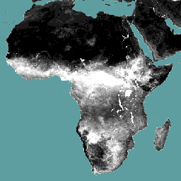
Beschreibung
Die Datenkomponente für die Verdunstung (E) (dekadal, in mm/Tag) ist die tatsächliche Verdunstung der Bodenoberfläche. Der Wert jedes Pixels stellt die durchschnittliche tägliche tatsächliche Verdunstung für das jeweilige Dekad dar.
Bänder
Pixelgröße
248,2 Meter
Bänder
| Name | Einheiten | Skalierung | Pixelgröße | Beschreibung |
|---|---|---|---|---|
L1-E-D |
mm | 0,1 | Meter | Verdunstung (dekadal) [mm] |
Nutzungsbedingungen
Nutzungsbedingungen
Die Ernährungs- und Landwirtschaftsorganisation der Vereinten Nationen (FAO) ist beauftragt, Informationen zu Ernährung, Lebensmitteln und Landwirtschaft zu sammeln, zu analysieren, zu interpretieren und zu verbreiten. In diesem Zusammenhang veröffentlicht sie eine Reihe von Datenbanken zu Themen, die mit dem Mandat der FAO zusammenhängen, und ermutigt zur Nutzung dieser Datenbanken für wissenschaftliche und Forschungszwecke. Entsprechend den Grundsätzen der Offenheit und des Teilens, die in der Open Data Licensing For Statistical Databases (Offene Datenlizenzierung für statistische Datenbanken) vorgesehen sind, und entsprechend dem Mandat der FAO sind Daten aus dem Water Productivity Open Access Portal (WaPOR) (Offenes Zugangsportal für Wasserproduktivität) als Teil von AQUASTAT – dem globalen Informationssystem der FAO für Wasser und Landwirtschaft – für die Nutzergemeinschaft kostenlos verfügbar.
Zitationen
FAO 2018. WaPOR Database Methodology: Level 1. Remote Sensing for Water Productivity Technical Report: Methodology Series. Rom, FAO. 72 Seiten
FAO 2020. WaPOR V2-Datenbankmethodik. Remote Sensing for Water Productivity Technical Report: Methodology Series. Rom, FAO. https://www.fao.org/3/ca9894en/CA9894EN.pdf
Die Earth Engine nutzen
Code-Editor (JavaScript)
var coll = ee.ImageCollection('FAO/WAPOR/3/L1_E_D');
var image = coll.first();
Map.setCenter(17.5, 20, 3);
Map.addLayer(image, {min: 0, max: 10});