- 利用可能なデータセットの期間
- 2017-01-01T00:00:00Z–2021-01-01T00:00:00Z
- データセット プロデューサー
- JAXA EORC
- タグ
説明
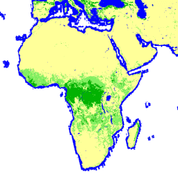
森林/非森林グローバル マップ(FNF)は、グローバル 25 m 解像度の PALSAR-2/PALSAR SAR モザイクの SAR 画像(後方散乱係数)を分類して、強い後方散乱ピクセルと弱い後方散乱ピクセルをそれぞれ「森林」と「非森林」に割り当てることで生成されます。ここで「森林」とは、面積が 0.5 ヘクタールを超え、森林被覆率が 10% を超える自然林を指します。この定義は、国連食糧農業機関(FAO)の定義と同じです。森林からのレーダー後方散乱は地域(気候帯)によって異なるため、森林/非森林の分類は、地域に依存する後方散乱のしきい値を使用して行われます。分類の精度は、現地写真と高解像度の光学衛星画像を使用して確認されます。
詳細情報:
宛先:
- 高緯度の森林地帯では、パスごとに後方散乱値が大きく異なる場合があります。これは、冬に木が凍結することで後方散乱強度が変化するためです。なお、この処理は森林/非森林の分類に影響する可能性があります。
バンド
バンド
ピクセルサイズ: 25 メートル(すべてのバンド)
| 名前 | 最小 | 最大 | ピクセルサイズ | 説明 |
|---|---|---|---|---|
fnf |
1 | 4 | 25 メートル | 森林/非森林の土地被覆分類 |
fnf クラス表
| 値 | 色 | 説明 |
|---|---|---|
| 1 | #00b200 | 深い森 |
| 2 | #83ef62 | Non-dense Forest |
| 3 | #ffff99 | 森林以外 |
| 4 | #0000ff | 水 |
利用規約
利用規約
JAXA はデータセットの所有権を保持しており、データセットの使用によって発生した、または発生する可能性のある問題について保証することはできません。データセットを使用して結果を公開する場合は、公開する際にデータの所有権を明示する必要があります。
引用
島田正延、伊藤琢也、本岡武、渡辺学、白石友博、Rajesh Thapa、Richard Lucas、「New Global Forest/Non-forest Maps from ALOS PALSAR Data (2007-2010)」(ALOS PALSAR データ(2007 ~ 2010 年)から作成された新しい世界の森林 / 非森林地図)、Remote Sensing of Environment、155、pp. 13 ~ 31、2014 年 12 月。 doi:10.1016/j.rse.2014.04.014.
Earth Engine で探索する
コードエディタ(JavaScript)
var dataset = ee.ImageCollection('JAXA/ALOS/PALSAR/YEARLY/FNF4')
                  .filterDate('2018-01-01', '2018-12-31');
var forestNonForest = dataset.select('fnf');
var forestNonForestVis = {
  min: 1,
  max: 4,
  palette: ['00b200','83ef62','ffff99','0000ff'],
};
Map.setCenter(136.85, 37.37, 4);
Map.addLayer(forestNonForest, forestNonForestVis, 'Forest/Non-Forest');