- データセットの可用性
- 1998-01-01T00:00:00Z–2025-10-16T14:00:00Z
- データセット プロバイダ
- JAXA 地球観測研究センター
- ケイデンス
- 1 時間
- タグ
説明
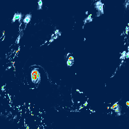
Global Satellite Mapping of Precipitation(GSMaP)は、0.1 × 0.1 度の解像度で 1 時間ごとの降雨量をグローバルに提供します。GSMaP は、3 時間間隔で世界中の降水量を観測する Global Precipitation Measurement(GPM)ミッションの成果物です。値は、GPM Core Observatory 衛星のマルチバンド パッシブ マイクロ波および赤外線放射計を使用して推定され、他の衛星のコンステレーションの支援を受けています。GPM の降水率取得アルゴリズムは、放射伝達モデルに基づいています。ゲージ調整後のレートは、NOAA/CPC ゲージ測定による GSMaP の 1 時間ごとの降雨率の 24 時間の累積を日降水量に最適化して計算されます。このデータセットは、GSMaP アルゴリズム バージョン 8(プロダクト バージョン 5)で処理されます。詳しくは、GSMaP の技術ドキュメントをご覧ください。
このデータセットには、GSMaP_MVK データが利用可能になると定期的に更新版に置き換えられる暫定版のプロダクト GSMaP_NRT が含まれています。商品は「status」というメタデータ プロパティでマークされます。商品が最初に利用可能になったとき、プロパティ値は「provisional」になります。仮の商品が最終バージョンで更新されると、この値は「permanent」に更新されます。詳細については、一般的なドキュメントをご覧ください。
バンド
Pixel Size
11132 メートル
帯域
| 名前 | 単位 | 最小 | 最大 | ピクセルサイズ | 説明 | ||||||||||||||||||||||||||||||||||||||||||||||||||||||||||||||||||||||||||||||||||||||||||||||
|---|---|---|---|---|---|---|---|---|---|---|---|---|---|---|---|---|---|---|---|---|---|---|---|---|---|---|---|---|---|---|---|---|---|---|---|---|---|---|---|---|---|---|---|---|---|---|---|---|---|---|---|---|---|---|---|---|---|---|---|---|---|---|---|---|---|---|---|---|---|---|---|---|---|---|---|---|---|---|---|---|---|---|---|---|---|---|---|---|---|---|---|---|---|---|---|---|---|---|---|
hourlyPrecipRate |
mm/hr | 0* | 204.88* | メートル | 1 時間ごとの降水量のスナップショット |
||||||||||||||||||||||||||||||||||||||||||||||||||||||||||||||||||||||||||||||||||||||||||||||
hourlyPrecipRateGC |
mm/hr | 0* | 200.36* | メートル | 雨量計に合わせて調整された 1 時間ごとの降水量のスナップショット |
||||||||||||||||||||||||||||||||||||||||||||||||||||||||||||||||||||||||||||||||||||||||||||||
observationTimeFlag |
h | -124.72* | 16.06* | メートル | ファイルの開始時刻からマイクロ波放射計(イメージャ/サウンダ)の観測時刻までの相対時間。1 時間のウィンドウ内に観測がない場合、時間は最後の観測からの経過時間(負の数)になります。 |
||||||||||||||||||||||||||||||||||||||||||||||||||||||||||||||||||||||||||||||||||||||||||||||
satelliteInfoFlag |
メートル | 使用された衛星/センサー |
|||||||||||||||||||||||||||||||||||||||||||||||||||||||||||||||||||||||||||||||||||||||||||||||||
gaugeQualityInfo |
count/d | 0* | 121* | メートル | ステータスが「provisional」の場合のゲージ調整の有無。1 は調整済み、0 は未調整を示します。ステータスが「permanent」の場合、ピクセル値はピクセルの調整に使用されるゲージ数の 1 日あたりの平均値です。 |
||||||||||||||||||||||||||||||||||||||||||||||||||||||||||||||||||||||||||||||||||||||||||||||
画像プロパティ検出
画像プロパティ
| 名前 | 型 | 説明 |
|---|---|---|
| AlgorithmID | STRING | この商品を生成したアルゴリズム(例: 3GSMAPH |
| AlgorithmVersion | STRING | このプロダクトを生成したアルゴリズムのバージョン |
| ProductVersion | STRING | 処理システムによって割り当てられたデータ バージョン |
| GenerationDateTime | STRING | このグラニュールが生成された日時 |
| ステータス | STRING | 永続的または仮 |
利用規約
利用規約
JAXA 全球降水観測システムのデータを使用して結果を公開する場合は、公開物の中でデータの所有権を明記してください(例: 「JAXA 全球降水観測システムによる準リアルタイム全球降水マップ(GSMaP_NRT)」は、宇宙航空研究開発機構 地球観測研究センターが作成し、配布しています)。GSMaP 降雨量プロダクトを利用した場合は、下記の主要な論文を引用してください。詳しくは、JAXA サイトポリシーとユーザーガイドをご覧ください。
引用
Kubota, T., K. Aonashi, T. Ushio, S. Shige, Y. 北Takayabu, M. Kachi、Y. Arai, T. Tashima, T. Masaki、N. Kawamoto, T. Mega, M. K. 山本、A. Hamada, M. Yamaji, G. Liu と R. Oki 2020: Global Satellite Mapping of Precipitation (GSMaP) products in the GPM era, Satellite precipitation measurement, Springer, https://doi.org/10.1007/978-3-030-24568-9_20。
DOI
Earth Engine で探索する
コードエディタ(JavaScript)
var dataset = ee.ImageCollection('JAXA/GPM_L3/GSMaP/v8/operational')
                  .filter(ee.Filter.date('2023-09-12', '2023-09-13'));
var precipitation = dataset.select('hourlyPrecipRate');
var precipitationVis = {
  min: 0.0,
  max: 10.0,
  palette:
      ['1621a2', 'ffffff', '03ffff', '13ff03', 'efff00', 'ffb103', 'ff2300'],
};
Map.setCenter(-90.7, 26.12, 3);
Map.addLayer(precipitation, precipitationVis, 'Precipitation');