- ডেটাসেট উপলব্ধতা
- 2018-01-01T00:00:00Z–2018-12-31T00:00:00Z
- ডেটাসেট প্রদানকারী
- ইসি জেআরসি
- ট্যাগ
বর্ণনা
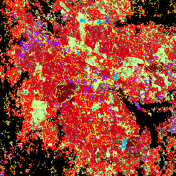
এই স্থানিক রাস্টার ডেটাসেটটি 10 মিটার রেজোলিউশনে মানুষের বসতিগুলিকে চিত্রিত করে এবং নির্মিত পরিবেশের কার্যকরী এবং উচ্চতা-সম্পর্কিত উপাদানগুলির পরিপ্রেক্ষিতে তাদের অভ্যন্তরীণ বৈশিষ্ট্যগুলি বর্ণনা করে।
GHSL ডেটা পণ্য সম্পর্কে আরও তথ্য GHSL ডেটা প্যাকেজ 2023 রিপোর্টে পাওয়া যাবে
গ্লোবাল হিউম্যান সেটেলমেন্ট লেয়ার (GHSL) প্রকল্পটি ইউরোপীয় কমিশন, জয়েন্ট রিসার্চ সেন্টার, এবং আঞ্চলিক ও নগর নীতির জন্য ডিরেক্টরেট-জেনারেল দ্বারা সমর্থিত।
ব্যান্ড
পিক্সেল সাইজ
10 মিটার
ব্যান্ড
| নাম | পিক্সেল সাইজ | বর্ণনা |
|---|---|---|
built_characteristics | মিটার | বসতি বৈশিষ্ট্য |
বিল্ট_ বৈশিষ্ট্য ক্লাস টেবিল
| মান | রঙ | বর্ণনা |
|---|---|---|
| 1 | #718c6c | খোলা জায়গা, কম গাছপালা পৃষ্ঠ |
| 2 | #8ad86b | খোলা জায়গা, মাঝারি গাছপালা পৃষ্ঠ |
| 3 | #c1ffa1 | খোলা জায়গা, উচ্চ গাছপালা পৃষ্ঠ |
| 4 | #01b7ff | খোলা জায়গা, জল পৃষ্ঠ |
| 5 | #ffd501 | খোলা জায়গা, রাস্তার উপরিভাগ |
| 11 | #d28200 | নির্মিত স্থান, আবাসিক, বিল্ডিং উচ্চতা <= 3 মি |
| 12 | #fe5900 | নির্মিত স্থান, আবাসিক, 3m < বিল্ডিং উচ্চতা <= 6m |
| 13 | #ff0101 | নির্মিত স্থান, আবাসিক, 6 মি < বিল্ডিং উচ্চতা <= 15 মি |
| 14 | #ce001b | নির্মিত স্থান, আবাসিক, 15m < বিল্ডিং উচ্চতা <= 30m |
| 15 | #7a000a | নির্মিত স্থান, আবাসিক, ভবন উচ্চতা > 30m |
| 21 | #ff9ff4 | নির্মিত স্থান, অ-আবাসিক, বিল্ডিং উচ্চতা <= 3 মি |
| 22 | #ff67e4 | নির্মিত স্থান, অনাবাসিক, 3 মি < বিল্ডিং উচ্চতা <= 6 মি |
| 23 | #f701ff | নির্মিত স্থান, অনাবাসিক, 6 মি < বিল্ডিং উচ্চতা <= 15 মি |
| 24 | #a601ff | নির্মিত স্থান, অ-আবাসিক, 15m < বিল্ডিং উচ্চতা <= 30m |
| 25 | #6e00fe | নির্মিত স্থান, অ-আবাসিক, বিল্ডিং উচ্চতা > 30m |
ব্যবহারের শর্তাবলী
ব্যবহারের শর্তাবলী
GHSL উন্মুক্ত এবং বিনামূল্যে ডেটা হিসাবে ইউরোপীয় কমিশন যৌথ গবেষণা কেন্দ্র দ্বারা উত্পাদিত হয়েছে। পুনঃব্যবহার অনুমোদিত, যদি উত্সটি স্বীকৃত হয়। আরও তথ্যের জন্য, অনুগ্রহ করে ব্যবহারের শর্তাবলী পড়ুন ( ইউরোপীয় কমিশন পুনঃব্যবহার এবং কপিরাইট বিজ্ঞপ্তি )।
উদ্ধৃতি
ডেটাসেট: পেসারেসি, মার্টিনো; Politis, Panagiotis (2023): GHS-BUILT-C R2023A - GHS সেটেলমেন্ট বৈশিষ্ট্য, সেন্টিনেল2 কম্পোজিট (2018) এবং অন্যান্য GHS R2023A ডেটা থেকে প্রাপ্ত। ইউরোপীয় কমিশন, জয়েন্ট রিসার্চ সেন্টার (জেআরসি) পিআইডি: http://data.europa.eu/89h/3c60ddf6-0586-4190-854b-f6aa0edc2a30 doi:10.2905/3c60ddf6-0586-4190-854b30df30
পদ্ধতি: পেসারেসি, মার্টিনো, মার্সেলো শিয়াভিনা, প্যানাজিওটিস পলিটিস, সার্জিও ফ্রেয়ার, কাতারজিনা ক্রাসনোদেবস্কা, জোহানেস এইচ. উহল, আলেসান্দ্রা ক্যারিওলি, এট আল। (2024)। পৃথিবী পর্যবেক্ষণ এবং জনসংখ্যা জরিপ ডেটার যৌথ মূল্যায়ন দ্বারা বিশ্বব্যাপী মানব বসতি স্তরের অগ্রগতি। ডিজিটাল আর্থের আন্তর্জাতিক জার্নাল 17(1)। doi:10.1080/17538947.2024.2390454
ডিওআই
আর্থ ইঞ্জিন দিয়ে অন্বেষণ করুন
কোড এডিটর (জাভাস্ক্রিপ্ট)
var image = ee.Image("JRC/GHSL/P2023A/GHS_BUILT_C/2018");
var built = image.select('built_characteristics');
Map.setCenter(77.58, 12.97, 13);
Map.addLayer(built, {}, 'Settlement_characteristics (2018)');