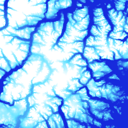
ArcticDEM היא יוזמה ציבורית-פרטית של הסוכנות הלאומית למודיעין גיאוגרפי (NGA) והקרן הלאומית למדע (NSF) שמטרתה ליצור באופן אוטומטי מודל דיגיטלי של פני השטח (DSM) באזור הארקטי ברזולוציה גבוהה ובאיכות גבוהה, באמצעות תמונות סטריאו אופטיות, מחשוב עתיר ביצועים ותוכנת פוטוגרמטריה בקוד פתוח. הוא כולל צמחייה, חופת עצים, בניינים ותכונות אחרות של פני השטח שנוצרו על ידי בני אדם. נכס ה-2m הוא אוסף של רצועות ולא פסיפס יחיד, בגלל הבדלים בהטלה בין הרצועות.
קובצי DEM עם פסיפס מורכבים מקובצי DEM של רצועות באיכות הכי טובה, שעברו מיזוג והחלקה כדי לצמצם אזורים ריקים וארטיפקטים של התאמת קצוות. נתוני מדידת הגובה של IceSAT שעברו סינון הוחלו על קובצי הרסטר כדי לשפר את הדיוק המוחלט.
פסיפסים של גרסה (V4.1) כוללים רצועות רסטר נוספות: count, mad, mindate ו-maxdate, כדי לספק מידע על מקור הנתונים ואי הוודאות.
תחום תדרים
גודל הפיקסל 2 מטרים
תחום תדרים
שם
יחידות
מינימום
מקסימום
גודל הפיקסל
תיאור
elevation
m
-416.45*
5971.24*
מטרים
גובה
count
מטרים
מספר נתוני ה-DEM מהמקור ששימשו לחישוב ערך הגובה בפיקסל הזה.
mad
m
מטרים
הסטייה המוחלטת החציונית של ערימת מערכי הנתונים מהערך החציוני של הגובה.
mindate
מטרים
התאריך המוקדם ביותר של מודלי הגבהים הדיגיטליים (DEM) של המקור ששימשו ליצירת הפסיפס, כמספר הימים שחלפו מאז 1 בינואר 2000.
maxdate
מטרים
התאריך האחרון של מודלי הגבהים הדיגיטליים (DEM) מהמקור ששימשו ליצירת הפסיפס, כמספר הימים מאז 1 בינואר 2000.
datamask
מטרים
מסכת הנתונים מציינת אם הגובה היה 0 או 1.
כאשר 0 מציין , מולא/מוזג עם מערך נתונים אחר או
הוסתר כ-NoData בשלבים של בקרת איכות.
1 מציין פלט של SETSM, חבילת התוכנה של אוניברסיטת אוהיו בנושא מיצוי פני השטח באמצעות מזעור של מרחב החיפוש מבוסס-TIN.
* ערך מינימלי או מקסימלי משוער
תנאים והגבלות
תנאים והגבלות
מדיניות National Science Foundation (מקור המימון העיקרי של PGC) מחייבת את החוקרים לציין את התמיכה של NSF בכל הפרסומים, דפי האינטרנט והראיונות לתקשורת.
השימוש בנתוני PGC ב-Earth Engine מחייב את המשתמשים לציין את PGC ואת החסות של NSF. בנוסף, צריך לציין את המקור המקורי של כל נתון של צד שלישי שסופק על ידי PGC.
ArcticDEM היא יוזמה ציבורית-פרטית של National Geospatial-Intelligence Agency (NGA) ו-National Science Foundation (NSF) ליצירה אוטומטית של מודל דיגיטלי של פני השטח (DSM) באיכות גבוהה וברזולוציה גבוהה של האזור הארקטי באמצעות תמונות סטריאו אופטיות, מחשוב עתיר ביצועים ותוכנת פוטוגרמטריה בקוד פתוח. הוא כולל צמחייה, חופת עצים, בניינים ותכונות אחרות של פני השטח שנוצרו על ידי האדם. ה…
[null,null,[],[],[],null,["# ArcticDEM Mosaic V4.1\n\nDataset Availability\n: 2012-06-03T00:00:00Z--2020-09-03T23:59:59Z\n\nDataset Provider\n:\n\n\n [University of Minnesota Polar Geospatial Center](https://www.pgc.umn.edu/data/arcticdem/)\n\nTags\n:\n[arctic](/earth-engine/datasets/tags/arctic) [dem](/earth-engine/datasets/tags/dem) [elevation-topography](/earth-engine/datasets/tags/elevation-topography) [geophysical](/earth-engine/datasets/tags/geophysical) [pgc](/earth-engine/datasets/tags/pgc) [umn](/earth-engine/datasets/tags/umn) \n\n#### Description\n\nArcticDEM is a National Geospatial-Intelligence Agency (NGA) and National\nScience Foundation (NSF) public-private initiative to automatically produce\na high-resolution, high-quality digital surface model (DSM) of the Arctic\nusing optical stereo imagery, high-performance computing, and open source\nphotogrammetry software. It includes vegetation, tree canopy, buildings, and\nother man-made surface features. The 2m asset is a collection of strips rather\nthan a single mosaic due to projection differences between strips.\n\nMosaicked DEM files are compiled from the best quality strip DEM files\nwhich have been blended and feathered to reduce void areas and edge-matching\nartifacts. Filtered IceSAT altimetry data has been applied to the raster\nfiles to improve absolute accuracy.\n\nThese version (V4.1) mosaics include additional raster bands:\n'count', 'mad','mindate', and 'maxdate' to provide\ninformation on data provenance and uncertainty.\n\n### Bands\n\n\n**Pixel Size**\n\n2 meters\n\n**Bands**\n\n| Name | Units | Min | Max | Pixel Size | Description |\n|-------------|-------|-----------|-----------|------------|-------------------------------------------------------------------------------------------------------------------------------------------------------------------------------------------------------------------------------------------------------------------------------------------------------|\n| `elevation` | m | -416.45\\* | 5971.24\\* | meters | Elevation |\n| `count` | | | | meters | Number of source DEMs used to calculate the elevation value at that pixel. |\n| `mad` | m | | | meters | Median absolute deviation of the stack of source datasets from the median elevation value. |\n| `mindate` | | | | meters | Earliest date of the source DEMs used to build the mosaic, as the number of days since January 1, 2000. |\n| `maxdate` | | | | meters | Latest date of the source DEMs used to build the mosaic, as the number of days since January 1, 2000. |\n| `datamask` | | | | meters | Data mask indicates whether the elevation was 0 or 1. where 0 indicates , Filled/merged with another dataset or masked out as NoData in quality control steps. 1 indicates output by SETSM, the Ohio State University's Surface Extraction with TIN-based Search-space Minimization software package. |\n\n\\* estimated min or max value\n\n### Terms of Use\n\n**Terms of Use**\n\nNational Science Foundation (PGC's primary funding source) policy requires\nresearchers to acknowledge NSF support in all publications, web pages, and\nmedia interviews.\n\nBy using PGC data in Earth Engine, users agree to cite PGC\nand its sponsorship by the NSF. The original source of any third-party data\nsupplied by PGC must also be properly attributed.\n\nFor more information see the PGC's\n[Acknowledgement Policy](https://www.pgc.umn.edu/guides/user-services/acknowledgement-policy/).\n\n### Citations\n\nCitations:\n\n- DEM(s) created by the Polar Geospatial Center from DigitalGlobe, Inc. imagery.\n Porter, Claire; Morin, Paul; Howat, Ian; Noh, Myoung-Jon; Bates, Brian;\n Peterman, Kenneth; Keesey, Scott; Schlenk, Matthew; Gardiner, Judith;\n Tomko, Karen; Willis, Michael; Kelleher, Cole; Cloutier, Michael; Husby, Eric;\n Foga, Steven; Nakamura, Hitomi; Platson, Melisa; Wethington, Michael, Jr.;\n Williamson, Cathleen; Bauer, Gregory; Enos, Jeremy; Arnold, Galen; Kramer, William;\n Becker, Peter; Doshi, Abhijit; D'Souza, Cristelle; Cummens, Pat; Laurier, Fabien;\n Bojesen, Mikkel, 2018, ArcticDEM, Harvard Dataverse, V1, \\[Date Accessed\\].\n\n### DOIs\n\n- \u003chttps://doi.org/10.7910/DVN/OHHUKH\u003e\n\n### Explore with Earth Engine\n\n| **Important:** Earth Engine is a platform for petabyte-scale scientific analysis and visualization of geospatial datasets, both for public benefit and for business and government users. Earth Engine is free to use for research, education, and nonprofit use. To get started, please [register for Earth Engine access.](https://console.cloud.google.com/earth-engine)\n\n### Code Editor (JavaScript)\n\n```javascript\nvar dataset = ee.Image('UMN/PGC/ArcticDEM/V4/2m_mosaic');\n\nvar elevationVis = {\n min: -50.0,\n max: 1000.0,\n palette: ['0d13d8', '60e1ff', 'ffffff'],\n bands: ['elevation'],\n};\n\nvar countVis = {\n min: 0,\n max: 10,\n palette: [\n 'black',\n 'blue',\n 'purple',\n 'cyan',\n 'green',\n 'yellow',\n 'red',\n ],\n bands: ['count'],\n};\n\nvar madVis = {\n min: 0,\n max: 50,\n palette: [\n '006633',\n 'E69800',\n 'D4E157',\n 'FFF59D',\n ],\n bands: ['mad'],\n};\n\nvar datamaskVis = {\n min: 0,\n max: 1,\n palette: [\n 'black',\n 'white',\n ],\n bands: ['datamask'],\n};\n\nMap.setCenter(-63.402, 66.368, 7);\n\nMap.addLayer(dataset, elevationVis, 'Elevation', true);\nMap.addLayer(dataset, countVis, 'Data Count', false);\nMap.addLayer(dataset, madVis, 'MAD', false);\nMap.addLayer(dataset, datamaskVis, 'Data Mask', false);\n```\n[Open in Code Editor](https://code.earthengine.google.com/?scriptPath=Examples:Datasets/UMN/UMN_PGC_ArcticDEM_V4_2m_mosaic) \n[ArcticDEM Mosaic V4.1](/earth-engine/datasets/catalog/UMN_PGC_ArcticDEM_V4_2m_mosaic) \nArcticDEM is a National Geospatial-Intelligence Agency (NGA) and National Science Foundation (NSF) public-private initiative to automatically produce a high-resolution, high-quality digital surface model (DSM) of the Arctic using optical stereo imagery, high-performance computing, and open source photogrammetry software. It includes vegetation, tree canopy, buildings, and other man-made surface features. The ... \nUMN/PGC/ArcticDEM/V4/2m_mosaic, arctic,dem,elevation-topography,geophysical,pgc,umn \n2012-06-03T00:00:00Z/2020-09-03T23:59:59Z \n50 -180 90 180 \nGoogle Earth Engine \nhttps://developers.google.com/earth-engine/datasets\n\n- [https://doi.org/10.7910/DVN/OHHUKH](https://doi.org/https://www.pgc.umn.edu/data/arcticdem/)\n- [https://doi.org/10.7910/DVN/OHHUKH](https://doi.org/https://developers.google.com/earth-engine/datasets/catalog/UMN_PGC_ArcticDEM_V4_2m_mosaic)"]]