-
פסיפס של ArcticDEM גרסה 4.1
ArcticDEM היא סוכנות לאומית לבינה גיאו-מרחבית (NGA) והקרן הלאומית למדע (NSF) – יוזמה ציבורית-ציבורית שנועדה ליצור באופן אוטומטי מודל משטח דיגיטלי (DSM) ברזולוציה גבוהה ובאיכות גבוהה של האזור הארקטי באמצעות תמונות סטריאו אופטיות, מחשוב עם ביצועים גבוהים ותוכנת פוטוגרמטריה בקוד פתוח. הוא כולל צמחייה, צל עצים, מבנים ו... arctic dem גובה-טופוגרפיה גיאופיזית pgc umn -
רצועות ArcticDEM
ArcticDEM היא סוכנות לאומית לבינה גיאו-מרחבית (NGA) והקרן הלאומית למדע (NSF) – יוזמה ציבורית-ציבורית שנועדה ליצור באופן אוטומטי מודל משטח דיגיטלי (DSM) ברזולוציה גבוהה ובאיכות גבוהה של האזור הארקטי באמצעות תמונות סטריאו אופטיות, מחשוב עם ביצועים גבוהים ותוכנת פוטוגרמטריה בקוד פתוח. הוא כולל צמחייה, צל עצים, מבנים ו... arctic dem גובה-טופוגרפיה גיאופיזית pgc umn -
פסיפס REMA
מודל גובה-רוחב של אנטארקטיקה (REMA) הוא מודל שטח דיגיטלי (DSM) ברזולוציה גבוהה של אנטארקטיקה, בעל רזולוציה גבוהה וחותמת זמן, ברזולוציה מרחבית של 2 מטר ו-8 מטר. קובצי DEM עם פסיפסים מורכבים מכמה רצועות שנרשמו ביחד, מוזגו ונוצות כדי לצמצם את הפריטים התואמים לקצוות. dem גובה-טופוגרפיה גיאופיזית pgc rema umn -
רצועות REMA באורך 2 מ'
מודל גובה-רוחב של אנטארקטיקה (REMA) הוא מודל שטח דיגיטלי (DSM) ברזולוציה גבוהה של אנטארקטיקה, בעל רזולוציה גבוהה וחותמת זמן, ברזולוציה מרחבית של 2 מטר ו-8 מטר. קובצי Strip DEM מתאימים לאזור החופף של הצמדים של התמונות הסטריאוסקופיות להזנת הקלט, כפי שהם נאספים על ידי DigitalGlobe ... dem גובה-טופוגרפיה גיאופיזית pgc rema umn -
רצועות REMA 8 מ'
מודל גובה-רוחב של אנטארקטיקה (REMA) הוא מודל שטח דיגיטלי (DSM) ברזולוציה גבוהה של אנטארקטיקה, בעל רזולוציה גבוהה וחותמת זמן, ברזולוציה מרחבית של 2 מטר ו-8 מטר. קובצי Strip DEM מתאימים לאזור החופף של הצמדים של התמונות הסטריאוסקופיות להזנת הקלט, כפי שהם נאספים על ידי DigitalGlobe ... dem גובה-טופוגרפיה גיאופיזית pgc rema umn
Datasets tagged umn in Earth Engine
[null,null,[],[[["\u003cp\u003eArcticDEM provides high-resolution digital surface models (DSMs) of the Arctic, including vegetation, tree canopy, and buildings, created through a public-private initiative using optical stereo imagery.\u003c/p\u003e\n"],["\u003cp\u003eREMA offers high-resolution, time-stamped DSMs of Antarctica at 2-meter and 8-meter resolutions, available as both individual strips and a mosaic.\u003c/p\u003e\n"],["\u003cp\u003eBoth ArcticDEM and REMA are produced using advanced photogrammetry techniques and high-performance computing.\u003c/p\u003e\n"],["\u003cp\u003eThe datasets are available in strip and mosaic formats, offering flexibility for different research and analysis needs.\u003c/p\u003e\n"]]],[],null,["# Datasets tagged umn in Earth Engine\n\n-\n\n |--------------------------------------------------------------------------------------------------------------------------------------------------------------------------------------------------------------------------------------------------------------------------------------------------------------------------------------------------------------------------------------------|\n | [### ArcticDEM Mosaic V4.1
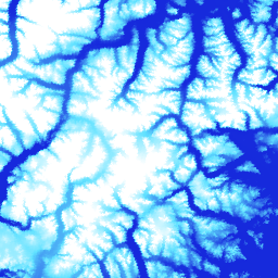
](/earth-engine/datasets/catalog/UMN_PGC_ArcticDEM_V4_2m_mosaic) |\n | ArcticDEM is a National Geospatial-Intelligence Agency (NGA) and National Science Foundation (NSF) public-private initiative to automatically produce a high-resolution, high-quality digital surface model (DSM) of the Arctic using optical stereo imagery, high-performance computing, and open source photogrammetry software. It includes vegetation, tree canopy, buildings, and ... |\n | [arctic](/earth-engine/datasets/tags/arctic) [dem](/earth-engine/datasets/tags/dem) [elevation-topography](/earth-engine/datasets/tags/elevation-topography) [geophysical](/earth-engine/datasets/tags/geophysical) [pgc](/earth-engine/datasets/tags/pgc) [umn](/earth-engine/datasets/tags/umn) |\n\n-\n\n |--------------------------------------------------------------------------------------------------------------------------------------------------------------------------------------------------------------------------------------------------------------------------------------------------------------------------------------------------------------------------------------------|\n | [### ArcticDEM Strips](/earth-engine/datasets/catalog/UMN_PGC_ArcticDEM_V3_2m) |\n | ArcticDEM is a National Geospatial-Intelligence Agency (NGA) and National Science Foundation (NSF) public-private initiative to automatically produce a high-resolution, high-quality digital surface model (DSM) of the Arctic using optical stereo imagery, high-performance computing, and open source photogrammetry software. It includes vegetation, tree canopy, buildings, and ... |\n | [arctic](/earth-engine/datasets/tags/arctic) [dem](/earth-engine/datasets/tags/dem) [elevation-topography](/earth-engine/datasets/tags/elevation-topography) [geophysical](/earth-engine/datasets/tags/geophysical) [pgc](/earth-engine/datasets/tags/pgc) [umn](/earth-engine/datasets/tags/umn) |\n\n-\n\n |---------------------------------------------------------------------------------------------------------------------------------------------------------------------------------------------------------------------------------------------------------------------------------------------------------------------------|\n | [### REMA Mosaic](/earth-engine/datasets/catalog/UMN_PGC_REMA_V1_1_8m) |\n | The Reference Elevation Model of Antarctica (REMA) is a high resolution, time-stamped Digital Surface Model (DSM) of Antarctica at 2-meter and 8-meter spatial resolutions. Mosaicked DEM files are compiled from multiple strips that have been co-registered, blended, and feathered to reduce edge-matching artifacts. |\n | [dem](/earth-engine/datasets/tags/dem) [elevation-topography](/earth-engine/datasets/tags/elevation-topography) [geophysical](/earth-engine/datasets/tags/geophysical) [pgc](/earth-engine/datasets/tags/pgc) [rema](/earth-engine/datasets/tags/rema) [umn](/earth-engine/datasets/tags/umn) |\n\n-\n\n |--------------------------------------------------------------------------------------------------------------------------------------------------------------------------------------------------------------------------------------------------------------------------------------------------------------------------|\n | [### REMA Strips 2m](/earth-engine/datasets/catalog/UMN_PGC_REMA_V1_2m) |\n | The Reference Elevation Model of Antarctica (REMA) is a high resolution, time-stamped Digital Surface Model (DSM) of Antarctica at 2-meter and 8-meter spatial resolutions. Strip DEM files correspond to the overlapping area of the input stereoscopic imagery pair strips as they are collected by DigitalGlobe's ... |\n | [dem](/earth-engine/datasets/tags/dem) [elevation-topography](/earth-engine/datasets/tags/elevation-topography) [geophysical](/earth-engine/datasets/tags/geophysical) [pgc](/earth-engine/datasets/tags/pgc) [rema](/earth-engine/datasets/tags/rema) [umn](/earth-engine/datasets/tags/umn) |\n\n-\n\n |--------------------------------------------------------------------------------------------------------------------------------------------------------------------------------------------------------------------------------------------------------------------------------------------------------------------------|\n | [### REMA Strips 8m](/earth-engine/datasets/catalog/UMN_PGC_REMA_V1_8m) |\n | The Reference Elevation Model of Antarctica (REMA) is a high resolution, time-stamped Digital Surface Model (DSM) of Antarctica at 2-meter and 8-meter spatial resolutions. Strip DEM files correspond to the overlapping area of the input stereoscopic imagery pair strips as they are collected by DigitalGlobe's ... |\n | [dem](/earth-engine/datasets/tags/dem) [elevation-topography](/earth-engine/datasets/tags/elevation-topography) [geophysical](/earth-engine/datasets/tags/geophysical) [pgc](/earth-engine/datasets/tags/pgc) [rema](/earth-engine/datasets/tags/rema) [umn](/earth-engine/datasets/tags/umn) |"]]