-
2000 Greenland Mosaic - Greenland Ice Mapping Project (GIMP)

קבוצת הנתונים הזו מספקת פסיפס תמונות מלא ברזולוציה של 15 מטרים של משטח הקרח בגרינלנד, שנוצר מנתוני Landsat 7 ETM+ ו-RADARSAT-1 SAR משנת 1999 עד 2002. השיטות כוללות שילוב של מיסוך ענן של תמונות, חידוד פאן, דגימה ושינוי גודל של תמונות, … arctic gimp greenland imagery nasa polar -
ArcticDEM Mosaic V4.1
ArcticDEM היא יוזמה ציבורית-פרטית של National Geospatial-Intelligence Agency (NGA) ו-National Science Foundation (NSF) ליצירה אוטומטית של מודל דיגיטלי של פני השטח (DSM) באיכות גבוהה וברזולוציה גבוהה של האזור הארקטי באמצעות תמונות סטריאו אופטיות, מחשוב עתיר ביצועים ותוכנת פוטוגרמטריה בקוד פתוח. הוא כולל צמחייה, צל עצים, בניינים ו… arctic dem elevation-topography geophysical pgc umn -
ArcticDEM Strips

ArcticDEM היא יוזמה ציבורית-פרטית של National Geospatial-Intelligence Agency (NGA) ו-National Science Foundation (NSF) ליצירה אוטומטית של מודל דיגיטלי של פני השטח (DSM) באיכות גבוהה וברזולוציה גבוהה של האזור הארקטי באמצעות תמונות סטריאו אופטיות, מחשוב עתיר ביצועים ותוכנת פוטוגרמטריה בקוד פתוח. הוא כולל צמחייה, צל עצים, בניינים ו… arctic dem elevation-topography geophysical pgc umn -
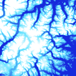
DEM של גרינלנד – פרויקט המיפוי של גרינלנד (GIMP)

מודל הגובה הדיגיטלי (DEM) הזה מורכב משילוב של מודלים של ASTER ו-SPOT-5 DEM עבור הפריפריה והשוליים של יריעת הקרח (כלומר, מתחת לגובה קו שיווי המשקל) מדרום לקו רוחב 82.5° צפון בערך, ופוטוקלינומטריה של AVHRR בחלק הפנימי של יריעת הקרח ובצפון הרחוק (Scambos and … arctic elevation-topography gimp greenland nasa polar -
מסכת קרח ואוקיינוס בגרינלנד – פרויקט מיפוי גרינלנד (GIMP)

קבוצת הנתונים הזו מספקת מסכות סיווג מלאות של קרח יבשתי ואוקיינוס ברזולוציה של 15 מ' עבור יריעת הקרח של גרינלנד. מיפוי כיסוי הקרח בוצע באמצעות שילוב של תמונות אורתורקטיפיקציה פאנכרומטיות (פס 8) מ-Landsat 7 Enhanced Thematic Mapper Plus (ETM+), שהופצו על ידי USGS, ו… arctic cryosphere gimp greenland ice nasa -
MEaSUREs Greenland Ice Velocity: Selected Glacier Site Velocity Maps from Optical Images Version 2

קבוצת הנתונים הזו, שמהווה חלק מתוכנית נאס"א Making Earth System Data Records for Use in Research Environments (MEaSUREs), כוללת מפות של מהירות חודשית ממוצעת לאזורים נבחרים של מוצא קרחונים. המפות נוצרות על ידי מעקב אחרי מאפיינים גלויים בין זוגות של תמונות אופטיות שצולמו על ידי Landsat … arctic cryosphere gimp greenland ice nasa
Datasets tagged arctic in Earth Engine
[null,null,[],[],["The content details datasets from the Greenland Ice Mapping Project (GIMP) and ArcticDEM initiatives. GIMP provides a 15m resolution ice/ocean classification mask and a 2000 image mosaic of Greenland derived from Landsat 7 and RADARSAT-1. It also includes a digital elevation model (DEM) and mean monthly glacier velocity maps. ArcticDEM, a joint NGA/NSF project, offers high-resolution digital surface models (DSMs) of the Arctic, encompassing features like vegetation and buildings.\n"]]