- ความพร้อมใช้งานของชุดข้อมูล
- 2012-06-03T00:00:00Z–2020-09-03T23:59:59Z
- ผู้ให้บริการชุดข้อมูล
- University of Minnesota Polar Geospatial Center
- แท็ก
คำอธิบาย
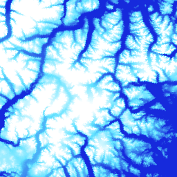
ArcticDEM เป็นโครงการริเริ่มภาครัฐและเอกชนของสำนักงานข่าวกรองภูมิสารสนเทศแห่งชาติ (NGA) และมูลนิธิวิทยาศาสตร์แห่งชาติ (NSF) เพื่อสร้างโมเดลพื้นผิวดิจิทัล (DSM) ความละเอียดสูงและมีคุณภาพสูงของอาร์กติกโดยอัตโนมัติโดยใช้ภาพสเตอริโอออปติคัล การประมวลผลประสิทธิภาพสูง และซอฟต์แวร์โฟโตแกรมเมตรีแบบโอเพนซอร์ส ซึ่งรวมถึงพืชพรรณ เรือนยอดของต้นไม้ อาคาร และ ลักษณะพื้นผิวอื่นๆ ที่มนุษย์สร้างขึ้น เนื้อหา 2 ม. เป็นชุดแถบภาพแทนที่จะเป็นภาพโมเสกภาพเดียวเนื่องจากความแตกต่างของการฉายภาพระหว่างแถบภาพ
ไฟล์ DEM แบบโมเสกได้รับการรวบรวมจากไฟล์ DEM แถบคุณภาพดีที่สุด ซึ่งได้รับการผสมและปรับขอบเพื่อลดพื้นที่ว่างและสิ่งประดิษฐ์ที่เกิดจากการจับคู่ขอบ เราได้ใช้ข้อมูลการวัดความสูงจากดาวเทียม IceSAT ที่กรองแล้วกับไฟล์แรสเตอร์ เพื่อปรับปรุงความแม่นยำสัมบูรณ์
โมเสกเวอร์ชัน (V4.1) เหล่านี้มีแบนด์แรสเตอร์เพิ่มเติม ได้แก่ "count", "mad", "mindate" และ "maxdate" เพื่อให้ข้อมูลเกี่ยวกับแหล่งที่มาและความไม่แน่นอนของข้อมูล
ย่านความถี่
ขนาดพิกเซล
2 เมตร
ย่านความถี่
| ชื่อ | หน่วย | ต่ำสุด | สูงสุด | ขนาดพิกเซล | คำอธิบาย |
|---|---|---|---|---|---|
elevation |
ม. | -416.45* | 5971.24* | เมตร | ระดับความสูง |
count |
เมตร | จำนวน DEM แหล่งที่มาที่ใช้ในการคำนวณค่าระดับความสูงที่พิกเซลนั้น |
|||
mad |
ม. | เมตร | ค่าเบี่ยงเบนสัมบูรณ์มัธยฐานของกองชุดข้อมูลแหล่งที่มาเทียบกับค่าระดับความสูงมัธยฐาน |
||
mindate |
เมตร | วันที่ที่เร็วที่สุดของ DEM แหล่งที่มาที่ใช้สร้างภาพโมเสกเป็นจำนวนวันนับตั้งแต่วันที่ 1 มกราคม 2000 |
|||
maxdate |
เมตร | วันที่ล่าสุดของ DEM แหล่งที่มาที่ใช้สร้างภาพโมเสกเป็นจำนวนวันนับตั้งแต่วันที่ 1 มกราคม 2000 |
|||
datamask |
เมตร | มาสก์ข้อมูลจะระบุว่าระดับความสูงเป็น 0 หรือ 1 โดย 0 หมายถึงเติม/ผสานกับชุดข้อมูลอื่น หรือ มาสก์เป็น NoData ในขั้นตอนการควบคุมคุณภาพ 1 แสดงเอาต์พุตจาก SETSM ซึ่งเป็นแพ็กเกจซอฟต์แวร์ Surface Extraction with TIN-based Search-space Minimization ของมหาวิทยาลัยโอไฮโอสเตต |
ข้อกำหนดในการใช้งาน
ข้อกำหนดในการใช้งาน
นโยบายของมูลนิธิวิทยาศาสตร์แห่งชาติ (แหล่งเงินทุนหลักของ PGC) กำหนดให้ นักวิจัยต้องรับทราบการสนับสนุนจาก NSF ในสิ่งพิมพ์ หน้าเว็บ และ การสัมภาษณ์สื่อทั้งหมด
การใช้ข้อมูล PGC ใน Earth Engine หมายความว่าผู้ใช้ยอมรับที่จะอ้างอิง PGC และการสนับสนุนของ NSF แหล่งที่มาดั้งเดิมของข้อมูลบุคคลที่สามที่ PGC จัดหาให้ต้องมีการระบุแหล่งที่มาอย่างถูกต้องด้วย
ดูข้อมูลเพิ่มเติมได้ที่นโยบายการรับทราบของ PGC
การอ้างอิง
DEM สร้างโดยศูนย์ Polar Geospatial จากภาพของ DigitalGlobe, Inc. Porter, Claire; Morin, Paul; Howat, Ian; Noh, Myoung-Jon; Bates, Brian; Peterman, Kenneth; Keesey, Scott; Schlenk, Matthew; Gardiner, Judith; Tomko, Karen; Willis, Michael; Kelleher, Cole; Cloutier, Michael; Husby, Eric; Foga, Steven; Nakamura, Hitomi; Platson, Melisa; Wethington, Michael, Jr.; Williamson, Cathleen; Bauer, Gregory; Enos, Jeremy; Arnold, Galen; Kramer, William; Becker, Peter; Doshi, Abhijit; D'Souza, Cristelle; Cummens, Pat; Laurier, Fabien; Bojesen, Mikkel, 2018, ArcticDEM, Harvard Dataverse, V1, [วันที่เข้าถึง]
DOI
สำรวจด้วย Earth Engine
ตัวแก้ไขโค้ด (JavaScript)
var dataset = ee.Image('UMN/PGC/ArcticDEM/V4/2m_mosaic');

var elevationVis = {
  min: -50.0,
  max: 1000.0,
  palette: ['0d13d8', '60e1ff', 'ffffff'],
  bands: ['elevation'],
};

var countVis = {
  min: 0,
  max: 10,
  palette: [
    'black',
    'blue',
    'purple',
    'cyan',
    'green',
    'yellow',
    'red',
  ],
  bands: ['count'],
};

var madVis = {
  min: 0,
  max: 50,
  palette: [
    '006633',
    'E69800',
    'D4E157',
    'FFF59D',
  ],
  bands: ['mad'],
};

var datamaskVis = {
  min: 0,
  max: 1,
  palette: [
    'black',
    'white',
  ],
  bands: ['datamask'],
};

Map.setCenter(-63.402, 66.368, 7);

Map.addLayer(dataset, elevationVis, 'Elevation', true);
Map.addLayer(dataset, countVis, 'Data Count', false);
Map.addLayer(dataset, madVis, 'MAD', false);
Map.addLayer(dataset, datamaskVis, 'Data Mask', false);