- Phạm vi cung cấp tập dữ liệu
- 2012-06-03T00:00:00Z–2020-09-03T23:59:59Z
- Nhà cung cấp tập dữ liệu
- Trung tâm Địa không gian vùng cực của Đại học Minnesota
- Thẻ
Mô tả
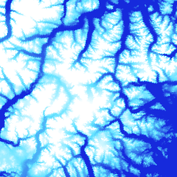
ArcticDEM là một sáng kiến công tư của Cơ quan Tình báo Địa không gian Quốc gia (NGA) và Quỹ Khoa học Quốc gia (NSF) nhằm tự động tạo ra một mô hình bề mặt kỹ thuật số (DSM) có độ phân giải cao và chất lượng cao của Bắc Cực bằng cách sử dụng hình ảnh lập thể quang học, điện toán hiệu suất cao và phần mềm đo đạc ảnh nguồn mở. Trong đó có thảm thực vật, tán cây, các toà nhà và những đặc điểm khác trên bề mặt do con người tạo ra. Tài sản 2m là một tập hợp các dải chứ không phải một bức khảm duy nhất do sự khác biệt về phép chiếu giữa các dải.
Các tệp DEM ghép được biên dịch từ các tệp DEM dải chất lượng cao nhất, được kết hợp và làm mờ để giảm các vùng trống và hiện tượng trùng khớp cạnh. Dữ liệu đo độ cao IceSAT đã được lọc được áp dụng cho các tệp raster để cải thiện độ chính xác tuyệt đối.
Những hình ảnh khảm phiên bản (V4.1) này bao gồm các dải tần raster bổ sung: "count", "mad", "mindate" và "maxdate" để cung cấp thông tin về nguồn gốc và độ không chắc chắn của dữ liệu.
Băng tần
Kích thước điểm ảnh
2 mét
Băng tần
| Tên | Đơn vị | Tối thiểu | Tối đa | Kích thước pixel | Mô tả |
|---|---|---|---|---|---|
elevation |
m | -416,45* | 5971,24* | mét | Độ cao |
count |
mét | Số lượng DEM nguồn được dùng để tính giá trị độ cao tại pixel đó. |
|||
mad |
m | mét | Độ lệch tuyệt đối trung bình của nhóm tập dữ liệu nguồn so với giá trị độ cao trung bình. |
||
mindate |
mét | Ngày sớm nhất của các DEM nguồn được dùng để tạo ảnh ghép, tính bằng số ngày kể từ ngày 1 tháng 1 năm 2000. |
|||
maxdate |
mét | Ngày mới nhất của các DEM nguồn được dùng để tạo bức ảnh ghép, tính bằng số ngày kể từ ngày 1 tháng 1 năm 2000. |
|||
datamask |
mét | Mặt nạ dữ liệu cho biết độ cao là 0 hay 1. Trong đó, 0 cho biết, Đã điền/hợp nhất với một tập dữ liệu khác hoặc bị che khuất dưới dạng NoData trong các bước kiểm soát chất lượng. 1 cho biết đầu ra của SETSM, gói phần mềm Giảm thiểu không gian tìm kiếm dựa trên TIN của Đại học Bang Ohio. |
Điều khoản sử dụng
Điều khoản sử dụng
Chính sách của Quỹ Khoa học Quốc gia (nguồn tài trợ chính của PGC) yêu cầu các nhà nghiên cứu phải ghi nhận sự hỗ trợ của NSF trong tất cả các ấn phẩm, trang web và cuộc phỏng vấn trên các phương tiện truyền thông.
Khi sử dụng dữ liệu PGC trong Earth Engine, người dùng đồng ý trích dẫn PGC và sự tài trợ của NSF. Nguồn gốc của mọi dữ liệu bên thứ ba do nội dung do người dùng tạo cung cấp cũng phải được ghi nhận đúng cách.
Để biết thêm thông tin, hãy xem Chính sách về việc xác nhận quyền sở hữu của nội dung do người dùng tạo.
Trích dẫn
DEM do Trung tâm không gian địa lý vùng cực tạo ra từ hình ảnh của DigitalGlobe, Inc. Porter, Claire; Morin, Paul; Howat, Ian; Noh, Myoung-Jon; Bates, Brian; Peterman, Kenneth; Keesey, Scott; Schlenk, Matthew; Gardiner, Judith; Tomko, Karen; Willis, Michael; Kelleher, Cole; Cloutier, Michael; Husby, Eric; Foga, Steven; Nakamura, Hitomi; Platson, Melisa; Wethington, Michael, Jr.; Williamson, Cathleen; Bauer, Gregory; Enos, Jeremy; Arnold, Galen; Kramer, William; Becker, Peter; Doshi, Abhijit; D'Souza, Cristelle; Cummens, Pat; Laurier, Fabien; Bojesen, Mikkel, 2018, ArcticDEM, Harvard Dataverse, V1, [Ngày truy cập].
DOI
Khám phá bằng Earth Engine
Trình soạn thảo mã (JavaScript)
var dataset = ee.Image('UMN/PGC/ArcticDEM/V4/2m_mosaic');

var elevationVis = {
  min: -50.0,
  max: 1000.0,
  palette: ['0d13d8', '60e1ff', 'ffffff'],
  bands: ['elevation'],
};

var countVis = {
  min: 0,
  max: 10,
  palette: [
    'black',
    'blue',
    'purple',
    'cyan',
    'green',
    'yellow',
    'red',
  ],
  bands: ['count'],
};

var madVis = {
  min: 0,
  max: 50,
  palette: [
    '006633',
    'E69800',
    'D4E157',
    'FFF59D',
  ],
  bands: ['mad'],
};

var datamaskVis = {
  min: 0,
  max: 1,
  palette: [
    'black',
    'white',
  ],
  bands: ['datamask'],
};

Map.setCenter(-63.402, 66.368, 7);

Map.addLayer(dataset, elevationVis, 'Elevation', true);
Map.addLayer(dataset, countVis, 'Data Count', false);
Map.addLayer(dataset, madVis, 'MAD', false);
Map.addLayer(dataset, datamaskVis, 'Data Mask', false);