-
2000 Greenland Mosaic – Dự án lập bản đồ băng ở Greenland (GIMP)

Tập dữ liệu này cung cấp một hình ảnh khảm hoàn chỉnh có độ phân giải 15 m về lớp băng Greenland, được lấy từ hình ảnh Landsat 7 ETM+ và RADARSAT-1 SAR từ năm 1999 đến năm 2002. Các phương pháp này bao gồm sự kết hợp giữa việc che mây trong hình ảnh, tăng độ sắc nét, lấy mẫu và đổi kích thước hình ảnh, … arctic gimp greenland imagery nasa polar -
ArcticDEM Mosaic phiên bản 4.1
ArcticDEM là một sáng kiến công tư của Cơ quan Tình báo Địa không gian Quốc gia (NGA) và Quỹ Khoa học Quốc gia (NSF) nhằm tự động tạo ra một mô hình bề mặt kỹ thuật số (DSM) chất lượng cao, có độ phân giải cao của Bắc Cực bằng cách sử dụng hình ảnh lập thể quang học, điện toán hiệu suất cao và phần mềm đo đạc quang học nguồn mở. Nơi này có thảm thực vật, tán cây, các toà nhà và… arctic dem elevation-topography geophysical pgc umn -
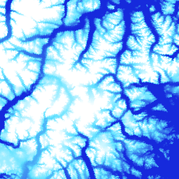
Các dải dữ liệu ArcticDEM

ArcticDEM là một sáng kiến công tư của Cơ quan Tình báo Địa không gian Quốc gia (NGA) và Quỹ Khoa học Quốc gia (NSF) nhằm tự động tạo ra một mô hình bề mặt kỹ thuật số (DSM) chất lượng cao, có độ phân giải cao của Bắc Cực bằng cách sử dụng hình ảnh lập thể quang học, điện toán hiệu suất cao và phần mềm đo đạc quang học nguồn mở. Nơi này có thảm thực vật, tán cây, các toà nhà và… arctic dem elevation-topography geophysical pgc umn -
DEM Greenland – Dự án lập bản đồ Greenland (GIMP)

Mô hình độ cao kỹ thuật số (DEM) này được xây dựng dựa trên sự kết hợp giữa DEM ASTER và SPOT-5 cho vùng ngoại vi và rìa của lớp băng (tức là bên dưới độ cao đường cân bằng) ở phía nam khoảng 82,5°B và phép đo độ dốc bằng ảnh AVHRR ở bên trong và cực bắc của lớp băng (Scambos và … arctic elevation-topography gimp greenland nasa polar -
Mặt nạ băng và đại dương của Greenland – Dự án lập bản đồ Greenland (GIMP)

Tập dữ liệu này cung cấp mặt nạ phân loại hoàn chỉnh về băng trên đất liền và đại dương ở độ phân giải 15 m cho lớp băng Greenland. Lớp băng được lập bản đồ bằng cách kết hợp hình ảnh toàn sắc (băng tần 8) được chỉnh sửa hình học từ Thiết bị lập bản đồ chuyên đề nâng cao (ETM+) Landsat 7, do USGS phân phối và … bắc cực cryosphere gimp greenland ice nasa -
MEaSUREs Greenland Ice Velocity: Selected Glacier Site Velocity Maps from Optical Images Version 2

Tập dữ liệu này là một phần của chương trình NASA Making Earth System Data Records for Use in Research Environments (MEaSUREs) (Tạo tập dữ liệu hệ thống Trái Đất để sử dụng trong môi trường nghiên cứu) và bao gồm các bản đồ vận tốc trung bình hằng tháng cho các khu vực cửa sông băng được chọn. Các bản đồ này được tạo bằng cách theo dõi các đối tượng có thể nhìn thấy giữa các cặp hình ảnh quang học do Landsat thu thập… bắc cực cryosphere gimp greenland ice nasa
Datasets tagged arctic in Earth Engine
[null,null,[],[],["The content details datasets from the Greenland Ice Mapping Project (GIMP) and ArcticDEM initiatives. GIMP provides a 15m resolution ice/ocean classification mask and a 2000 image mosaic of Greenland derived from Landsat 7 and RADARSAT-1. It also includes a digital elevation model (DEM) and mean monthly glacier velocity maps. ArcticDEM, a joint NGA/NSF project, offers high-resolution digital surface models (DSMs) of the Arctic, encompassing features like vegetation and buildings.\n"]]