- 利用可能なデータセットの期間
- 2015-01-01T00:00:00Z–2025-04-08T00:00:00Z
- データセット プロデューサー
- アメリカ地質調査所
- タグ
説明
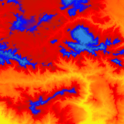
これは、3D Elevation Program(3DEP)の 1 m ピクセルサイズの画像のタイル コレクションです。3DEP のデータ保有は、The National Map の標高レイヤとして機能し、米国の地球科学研究とマッピング アプリケーションの基礎となる標高情報を提供します。
この DEM の標高は、地形の地表面を表します。 USGS 標準の 1 m ピクセルサイズの DEM は、1 m ピクセルサイズ以上の解像度の画像の高解像度光検出および測距(LiDAR)ソースデータからのみ生成されます。1 m ピクセルサイズの DEM サーフェスは、コレクション プロジェクト内ではシームレスですが、プロジェクト間では必ずしもシームレスではありません。 米国本土(CONUS)内の 1 m ピクセルサイズの DEM のタイルに使用される空間参照は、メートル単位のユニバーサル横メルカトル図法(UTM)で、1983 年の北米測地系(NAD83)に準拠しています。地表面の標高値はすべてメートル単位で、1988 年の北米鉛直測地系(NAVD88)を参照しています。各タイルは、そのタイルが存在する UTM ゾーンに配布されます。タイルが 2 つの UTM ゾーンにまたがる場合は、両方のゾーンで配信されます。 この場合や、画像が重複している場合、同じ領域をカバーする画像でも標高値が若干異なることがあります。
1 m ピクセルサイズの DEM は、3DEP プロダクト スイートで提供される標準 DEM の中で最も解像度が高いものです。10 m の 3DEP データセットは、 USGS_3DEP_10m_collectionで入手できます。
バンド
バンド
ピクセルサイズ: 1 メートル(すべてのバンド)
| 名前 | 単位 | ピクセルサイズ | 説明 |
|---|---|---|---|
elevation |
m | 1 メートル | 標高(NAVD88) |
利用規約
利用規約
アメリカ地質調査所(USGS)の情報はほとんどがパブリック ドメインに属しており、制限なく使用できます。情報源として USGS を 明記またはクレジットする方法については、こちらをご覧ください。
引用
U.S. Geological Survey, 3D Elevation Program 1-Meter Resolution Digital Elevation Model.
Earth Engine で探索する
コードエディタ(JavaScript)
var dataset = ee.ImageCollection('USGS/3DEP/1m');
var visualization = {
  min: 0,
  max: 3000,
  palette: [
    '3ae237', 'b5e22e', 'd6e21f', 'fff705', 'ffd611', 'ffb613', 'ff8b13',
    'ff6e08', 'ff500d', 'ff0000', 'de0101', 'c21301', '0602ff', '235cb1',
    '307ef3', '269db1', '30c8e2', '32d3ef', '3be285', '3ff38f', '86e26f'
  ],
};
Map.setCenter(-119.0, 34.6, 10);
Map.addLayer(dataset, visualization, 'elevation');