- در دسترس بودن مجموعه دادهها
- 2010-01-01T00:00:00Z–2010-01-01T00:00:00Z
- تولیدکننده مجموعه داده
- سازمان زمینشناسی آمریکا (USGS)
- برچسبها
توضیحات
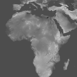
مجموعه دادههای ارتفاعی زمین با وضوح چندگانه جهانی ۲۰۱۰ (GMTED2010) شامل دادههای ارتفاعی برای کره زمین است که از منابع مختلف با وضوح ۷.۵ ثانیه قوسی جمعآوری شده است. جزئیات بیشتر در گزارش مجموعه دادهها موجود است.
مجموعه دادههای منبع اصلی برای GMTED2010، دادههای ارتفاعی دیجیتال زمین SRTM (DTED®، https://www2.jpl.nasa.gov/srtm/ ) (void-filled) 1-ثانیه قوسی NGA است. برای مناطق جغرافیایی خارج از منطقه پوشش SRTM و برای پر کردن حفرههای باقی مانده در دادههای SRTM، از منابع زیر استفاده شد: DTED® غیر SRTM، دادههای ارتفاعی دیجیتال کانادا (CDED) با دو وضوح تصویر، Satellite Pour l''Observation de la Terre (SPOT 5) Reference3D، مجموعه دادههای ارتفاعی ملی (NED) برای ایالات متحده و آلاسکا، مدل ارتفاعی دیجیتال 9 ثانیهای GEODATA (DEM) برای استرالیا، یک DEM رادار ماهوارهای و ارتفاعسنج لیزری قطب جنوب، و یک DEM رادار ارتفاعسنج ماهوارهای گرینلند.
این مجموعه داده جایگزین مدل ارتفاعی GTOPO30 میشود.
باندها
باندها
اندازه پیکسل: ۲۳۱.۹۲ متر (همه باندها)
| نام | واحدها | اندازه پیکسل | توضیحات |
|---|---|---|---|
std | متر | ۲۳۱.۹۲ متر | انحراف معیار |
min | متر | ۲۳۱.۹۲ متر | حداقل |
med | متر | ۲۳۱.۹۲ متر | میانه |
mea | متر | ۲۳۱.۹۲ متر | میانگین |
max | متر | ۲۳۱.۹۲ متر | حداکثر |
dsc | متر | ۲۳۱.۹۲ متر | نمونه |
be75 | متر | ۲۳۱.۹۲ متر | تأکید بر خطوط شکست، با حفظ هرگونه حداقل ارتفاع یا حداکثر ارتفاع روی یک خط شکست که از پنجره تحلیل مشخص شده عبور میکند، ویژگیهای توپوگرافی بحرانی (نهرها یا پشتهها) را در چشمانداز حفظ میکند. |
شرایط استفاده
شرایط استفاده
بیشتر اطلاعات سازمان زمینشناسی ایالات متحده (USGS) در حوزه عمومی قرار دارد و میتوان بدون محدودیت از آنها استفاده کرد. اطلاعات بیشتر در مورد تأیید یا اعتباربخشی به USGS به عنوان منبع اطلاعات در دسترس است.
نقل قولها
دادههای ارتفاعی چندوضوحی جهانی زمین ۲۰۱۰ با حسن نیت از سازمان زمینشناسی ایالات متحده
با موتور زمین کاوش کنید
ویرایشگر کد (جاوااسکریپت)
var dataset = ee.Image('USGS/GMTED2010_FULL');
var elevation = dataset.select('min');
var elevationVis = {
  min: -100.0,
  max: 6500.0,
  gamma: 3.5,
};
Map.setCenter(17.93, 7.71, 2);
Map.addLayer(elevation, elevationVis, 'Minimum Elevation');