- در دسترس بودن مجموعه دادهها
- ۲۰۰۰-۰۲-۱۱T۰۰:۰۰:۰۰Z–۲۰۰۰-۰۲-۲۲T۰۰:۰۰:۰۰Z
- تولیدکننده مجموعه داده
- صندوق جهانی طبیعت (WWF)
- برچسبها
توضیحات
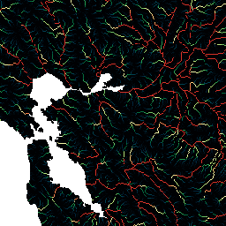
HydroSHEDS یک محصول نقشهبرداری است که اطلاعات هیدروگرافی را برای کاربردهای منطقهای و جهانی در قالبی منسجم ارائه میدهد. این نرمافزار مجموعهای از مجموعه دادههای زمینمرجع (بردار و رستری) را در مقیاسهای مختلف، از جمله شبکههای رودخانهای، مرزهای حوزه آبخیز، جهتهای زهکشی و تجمع جریان ارائه میدهد. HydroSHEDS بر اساس دادههای ارتفاعی بهدستآمده در سال ۲۰۰۰ توسط ماموریت توپوگرافی رادار شاتل ناسا (SRTM) است.
این مجموعه داده تجمع جریان، میزان مساحت بالادست (به تعداد سلولها) که به هر سلول تخلیه میشود را تعریف میکند. لایه جهت زهکشی برای تعریف اینکه کدام سلولها به سلول هدف جریان مییابند، استفاده میشود. تعداد سلولهای تجمع یافته اساساً معیاری از مساحت حوضه آبریز بالادست است. با این حال، از آنجایی که اندازه سلول مجموعه داده HydroSHEDS به عرض جغرافیایی بستگی دارد، مقدار تجمع سلول را نمیتوان مستقیماً به مساحت زهکشی بر حسب کیلومتر مربع تبدیل کرد. مقادیر از ۱ در ارتفاعات توپوگرافی (منابع رودخانه) تا اعداد بسیار بزرگ (در حدود میلیونها سلول) در دهانه رودخانههای بزرگ متغیر است.
این مجموعه داده با وضوح ۱۵ ثانیه قوسی است. مجموعه دادههای موجود با وضوح ۱۵ ثانیه قوسی عبارتند از DEM با شرایط هیدرولوژیکی، جهت زهکشی (جریان) و تجمع جریان.
توجه داشته باشید که کیفیت دادههای HydroSHEDS برای مناطق بالاتر از عرض جغرافیایی ۶۰ درجه شمالی به طور قابل توجهی پایینتر است، زیرا هیچ داده ارتفاعی SRTM در دسترس نیست و بنابراین از DEM با وضوح کمتر استفاده شده است (HYDRO1k توسط USGS ارائه شده است).
HydroSHEDS توسط برنامه علوم حفاظت از محیط زیست صندوق جهانی حیات وحش (WWF) با همکاری سازمان زمین شناسی ایالات متحده، مرکز بین المللی کشاورزی گرمسیری، سازمان حفاظت از طبیعت و مرکز تحقیقات سیستم های زیست محیطی دانشگاه کاسل آلمان توسعه داده شده است.
باندها
باندها
اندازه پیکسل: ۴۶۳.۸۳ متر (همه باندها)
| نام | حداقل | مکس | اندازه پیکسل | توضیحات |
|---|---|---|---|---|
b1 | ۱* | ۲.۷۸۶۵۱e+۰۷* | ۴۶۳.۸۳ متر | تجمع جریان |
شرایط استفاده
شرایط استفاده
دادههای HydroSHEDS برای استفاده غیرتجاری و تجاری رایگان هستند. برای اطلاعات بیشتر، لطفاً به توافقنامه مجوز مراجعه کنید.
نقل قولها
لنر، ب.، وردین، ک.، جارویس، آ. (2008): هیدروگرافی جهانی جدید برگرفته از دادههای ارتفاعی فضایی. Eos، Transactions، AGU، 89(10): 93-94.
با موتور زمین کاوش کنید
ویرایشگر کد (جاوااسکریپت)
var dataset = ee.Image('WWF/HydroSHEDS/15ACC');
var flowAccumulation = dataset.select('b1');
var flowAccumulationVis = {
  min: 0.0,
  max: 500.0,
  palette: [
    '000000', '023858', '006837', '1a9850', '66bd63', 'a6d96a', 'd9ef8b',
    'ffffbf', 'fee08b', 'fdae61', 'f46d43', 'd73027'
  ],
};
Map.setCenter(-121.652, 38.022, 8);
Map.addLayer(flowAccumulation, flowAccumulationVis, 'Flow Accumulation');