- در دسترس بودن مجموعه دادهها
- ۲۰۰۰-۰۲-۱۱T۰۰:۰۰:۰۰Z–۲۰۰۰-۰۲-۲۲T۰۰:۰۰:۰۰Z
- تولیدکننده مجموعه داده
- صندوق جهانی طبیعت (WWF)
- برچسبها
توضیحات
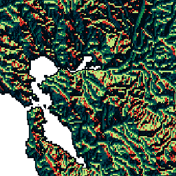
HydroSHEDS یک محصول نقشهبرداری است که اطلاعات هیدروگرافی را برای کاربردهای منطقهای و جهانی در قالبی منسجم ارائه میدهد. این نرمافزار مجموعهای از مجموعه دادههای زمینمرجع (بردار و رستری) را در مقیاسهای مختلف، از جمله شبکههای رودخانهای، مرزهای حوزه آبخیز، جهتهای زهکشی و تجمع جریان ارائه میدهد. HydroSHEDS بر اساس دادههای ارتفاعی بهدستآمده در سال ۲۰۰۰ توسط ماموریت توپوگرافی رادار شاتل ناسا (SRTM) است.
این مجموعه داده جهت زهکشی، جهت جریان از هر سلول در DEM شرطی شده به سمت شیب تندترین همسایه آن را تعریف میکند. مقادیر جهت زهکشی از ۱ تا ۱۲۸ متغیر است. تمام سلولهای خروجی نهایی به اقیانوس با مقدار ۰ علامتگذاری شدهاند. تمام سلولهایی که پایینترین نقطه یک حوضه درونریز (سینک داخلی) را نشان میدهند با مقدار -۱ علامتگذاری شدهاند. مقادیر جهت زهکشی از قرارداد اتخاذ شده توسط پیادهسازی جهت جریان ESRI پیروی میکنند: ۱=E، ۲=SE، ۴=S، ۸=SW، ۱۶=W، ۳۲=NW، ۶۴=N، ۱۲۸=NE.
این مجموعه داده با وضوح 30 ثانیه قوسی است. مجموعه دادههای موجود با وضوح 30 ثانیه قوسی عبارتند از DEM با شرایط هیدرولوژیکی، جهت زهکشی (جریان) و تجمع جریان.
توجه داشته باشید که کیفیت دادههای HydroSHEDS برای مناطق بالاتر از عرض جغرافیایی ۶۰ درجه شمالی به طور قابل توجهی پایینتر است، زیرا هیچ داده ارتفاعی SRTM در دسترس نیست و بنابراین از DEM با وضوح کمتر استفاده شده است (HYDRO1k توسط USGS ارائه شده است).
HydroSHEDS توسط برنامه علوم حفاظت از محیط زیست صندوق جهانی حیات وحش (WWF) با همکاری سازمان زمین شناسی ایالات متحده، مرکز بین المللی کشاورزی گرمسیری، سازمان حفاظت از طبیعت و مرکز تحقیقات سیستم های زیست محیطی دانشگاه کاسل آلمان توسعه داده شده است.
باندها
باندها
اندازه پیکسل: ۹۲۷.۶۷ متر (همه باندها)
| نام | حداقل | مکس | اندازه پیکسل | توضیحات |
|---|---|---|---|---|
b1 | 0* | ۲۵۵* | ۹۲۷.۶۷ متر | مقادیر ممکن برای جهت زهکشی: ۱=شرق، ۲=جنوب شرقی، ۴=جنوب، ۸=جنوب غربی، ۱۶=غرب، ۳۲=شمال غربی، ۶۴=شمال، ۱۲۸=شمال شرقی؛ سلولهای خروجی نهایی به اقیانوس با مقدار ۰ علامتگذاری میشوند و سلولهایی که پایینترین نقطه یک حوضه درونریز (سینک داخلی) را نشان میدهند با مقدار ۲۵۵ علامتگذاری میشوند (مقدار اولیه ۱-). |
شرایط استفاده
شرایط استفاده
دادههای HydroSHEDS برای استفاده غیرتجاری و تجاری رایگان هستند. برای اطلاعات بیشتر، لطفاً به توافقنامه مجوز مراجعه کنید.
نقل قولها
لنر، ب.، وردین، ک.، جارویس، آ. (2008): هیدروگرافی جهانی جدید برگرفته از دادههای ارتفاعی فضایی. Eos، Transactions، AGU، 89(10): 93-94.
با موتور زمین کاوش کنید
ویرایشگر کد (جاوااسکریپت)
var dataset = ee.Image('WWF/HydroSHEDS/30DIR');
var drainageDirection = dataset.select('b1');
var drainageDirectionVis = {
  min: 1.0,
  max: 128.0,
  palette: [
    '000000', '023858', '006837', '1a9850', '66bd63', 'a6d96a', 'd9ef8b',
    'ffffbf', 'fee08b', 'fdae61', 'f46d43', 'd73027'
  ],
};
Map.setCenter(-121.652, 38.022, 8);
Map.addLayer(drainageDirection, drainageDirectionVis, 'Drainage Direction');