- Właściciel katalogu
- Forest Data Partnership
- Dostępność zbioru danych
- 2020-01-01T00:00:00Z–2023-12-31T23:59:59Z
- Dostawca zbioru danych
- Opracowano przez Google na potrzeby Forest Data Partnership
- Tagi
Opis
Uwaga: ten zbiór danych nie został jeszcze poddany recenzji. Więcej informacji znajdziesz w pliku README na GitHubie.
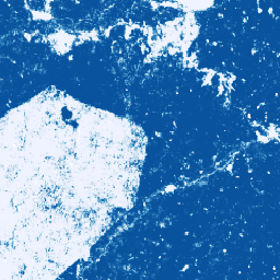
Ta kolekcja obrazów zawiera szacunkowe prawdopodobieństwo dla każdego piksela, że dany obszar jest zajęty przez towar. Szacunki prawdopodobieństwa są podawane z dokładnością do 10 metrów i generowane przez model uczenia maszynowego. Szczegółowe informacje znajdziesz w dokumentacji technicznej w repozytorium Forest Data Partnership w GitHubie.
Głównym celem tej kolekcji obrazów jest wspieranie misji Forest Data Partnership, która ma na celu powstrzymanie i odwrócenie procesu utraty lasów w wyniku produkcji towarów poprzez wspólną poprawę globalnego monitorowania, śledzenia łańcucha dostaw i odbudowy lasów.
Ten zbiór danych obejmuje obecnie te kraje: Ekwador, Ghana, Indonezja, Kolumbia, Peru i Wybrzeże Kości Słoniowej.
Ten produkt z danymi społecznościowymi będzie się z czasem rozwijać, ponieważ społeczność będzie udostępniać więcej danych, a model używany do tworzenia map będzie się stale ulepszać. Jeśli chcesz przesłać ogólną opinię lub dodatkowe zbiory danych, aby ulepszyć te warstwy, skorzystaj z tego formularza.
Ograniczenia: dane wyjściowe modelu są ograniczone do wybranych krajów w postaci kompozycji za lata kalendarzowe 2020 i 2023. Nie wszystkie regiony danych wyjściowych są dobrze reprezentowane przez dane treningowe. Dokładność jest podawana w formie zbiorczej i będzie się różnić w zależności od lokalizacji geograficznej oraz progów wybranych przez użytkownika. Artefakty czujnika oparte na dostępności danych, nierównomierności w kierunku poprzecznym lub zachmurzeniu mogą być widoczne w prawdopodobieństwach wyjściowych i powodować błędy klasyfikacji przy niektórych wartościach progowych.
Pamiętaj, że ten zbiór danych ma oddzielne warunki korzystania dla użytkowników komercyjnych Earth Engine. Szczegółowe informacje znajdziesz na karcie „Warunki korzystania”.
Pasma
Rozmiar piksela
10 metrów
Pasma
| Nazwa | Minimum | Maks. | Rozmiar piksela | Opis |
|---|---|---|---|---|
probability |
0 | 1 | metry | Prawdopodobieństwo, że piksel zawiera drzewa kakaowe w danym roku. |
Warunki korzystania z usługi
Warunki korzystania z usługi
W przypadku użytkowników niekomercyjnych korzystanie z tego zbioru danych podlega licencji CC-BY 4.0 NC i wymaga podania następującej informacji o autorstwie: „Wyprodukowano przez Google na potrzeby Forest Data Partnership”.
Jeśli chcesz używać zbioru danych w celach komercyjnych, możesz poprosić o dostęp za pomocą tego formularza. Dostęp będzie przyznawany lub odmawiany w zależności od konkretnego przypadku. Komercyjne wykorzystanie zbioru danych podlega Warunkom korzystania ze zbiorów danych Forest Data Partnership do celów komercyjnych.
Zawiera zmodyfikowane dane z satelit Copernicus Sentinel [od 2015 r.]. Zapoznaj się z informacjami prawnymi dotyczącymi danych z satelitów Sentinel.
Cytaty
Forest Data Partnership. 2025 r. Modele społecznościowe 2025a Online
Odkrywanie za pomocą Earth Engine
Edytor kodu (JavaScript)
Map.setCenter(-7.67, 6.71, 11);

var collection = ee.ImageCollection(
  'projects/forestdatapartnership/assets/cocoa/model_2025a');

var cocoa2020 = collection.filterDate('2020-01-01', '2020-12-31').mosaic();
Map.addLayer(
  cocoa2020.selfMask(), {min: 0.5, max: 1, palette: 'white,blue'}, 'cocoa 2020');

var cocoa2023 = collection.filterDate('2023-01-01', '2023-12-31').mosaic();
Map.addLayer(
  cocoa2023.selfMask(), {min: 0.5, max: 1, palette: 'white,green'}, 'cocoa 2023');