- مالک کاتالوگ
- ردیابی طبیعت
- در دسترس بودن مجموعه دادهها
- 2018-01-01T00:00:00Z–2020-12-31T23:59:59Z
- ارائه دهنده مجموعه داده
- گوگل
- برچسبها
- ، اتصال اکولوژیکی
توضیحات
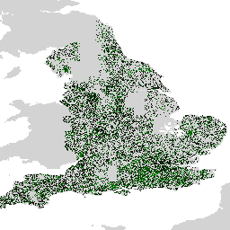
مجموعه دادههای Farmscapes 2020 نقشههای احتمال با وضوح بالا (25 سانتیمتر) را برای سه ویژگی نیمهطبیعی کلیدی در مناظر کشاورزی انگلستان ارائه میدهد: پرچینها، جنگلها و دیوارهای سنگی. این مجموعه دادهها با همکاری مرکز بازیابی طبیعت آکسفورد لورهولم توسعه داده شده است تا به عنوان پایهای برای کاربردهایی از جمله احیای چشمانداز، نظارت بر تنوع زیستی و تجزیه و تحلیل اتصال اکولوژیکی عمل کند.
این مجموعه داده با اعمال یک مدل مبدل بینایی بر روی موزاییکی از تصاویر هوایی با وضوح بالا، که با استفاده از مجموعه بزرگی از برچسبهای حاشیهنویسی شده توسط انسان آموزش داده شدهاند، تولید شده است. خروجی شامل سه لایه احتمال متمایز است، یکی برای هر کلاس ویژگی. این قالب احتمالی به کاربران اجازه میدهد تا آستانههای سفارشی را برای تولید نقشههای ویژگی دودویی متناسب با نیازهای تحلیلی خاص خود اعمال کنند.
محدودیتها
- محدوده جغرافیایی: عملکرد مدل در محیطهای شهری متراکم و مناطق کوهستانی کاهش مییابد، که در دادههای آموزشی که عمدتاً بر مناظر روستایی متمرکز بودند، کمتر نشان داده شده بودند.
- دقت زمانی: تصاویر منبع بین سالهای ۲۰۱۸ تا ۲۰۲۰ گرفته شدهاند. در نتیجه، مجموعه دادهها تغییرات چشمانداز را که از این دوره رخ داده است، در نظر نمیگیرد.
- عملکرد مختص به کلاس: کلاس دیوار سنگی در مقایسه با جنگل و پرچین، دقت کمتری را نشان میدهد که نتیجه عدم تعادل قابل توجه کلاس در دادههای آموزشی است.
مجموعه دادههای اروپا
علاوه بر مجموعه دادههای اولیه برای انگلستان، یک نسخه اولیه در مقیاس اروپایی تولید شده است. این مجموعه دادهها تحت اعتبارسنجی کمی یکسانی قرار نگرفتهاند و باید به عنوان یک نسخه آزمایشی در نظر گرفته شوند. درخواست دسترسی به این مجموعه دادهها با ارسال این فرم امکانپذیر است.
باندها
اندازه پیکسل
۰.۲۵ متر
باندها
| نام | حداقل | مکس | مقیاس | اندازه پیکسل | توضیحات |
|---|---|---|---|---|---|
B0 | 0 | ۲۵۰ | ۰.۰۰۴ | متر | احتمال پرچین (مقیاسبندی شده به [0-250]). |
B1 | 0 | ۲۵۰ | ۰.۰۰۴ | متر | احتمال دیوار سنگی (مقیاسبندی شده به [0-250]). |
B2 | 0 | ۲۵۰ | ۰.۰۰۴ | متر | احتمال جنگل/درخت (مقیاسبندی شده به [0-250]). |
شرایط استفاده
شرایط استفاده
این مجموعه داده تحت مجوز CC-BY 4.0 منتشر شده است و نیاز به ذکر منبع زیر دارد: «این مجموعه داده توسط گوگل تولید شده است».
نقل قولها
میکل آنژ کونسروا، الکس ویلسون، شارلوت استانتون، ویشال باچو، وارون گلشن، "نقشهبرداری از مناظر کشاورزی از طریق سنجش از دور" (در دست بررسی). doi:10.48550/arXiv.2506.13993 ،
با موتور زمین کاوش کنید
ویرایشگر کد (جاوااسکریپت)
var farmscapes =
    ee.ImageCollection('projects/nature-trace/assets/farmscapes/england_v1_0')
        .mosaic();
Map.addLayer(farmscapes, {}, 'Raw probs', false);

var stone_wall = farmscapes.select(['B1']);
stone_wall = stone_wall.updateMask(stone_wall.gt(250 / 4));
Map.addLayer(
    stone_wall, {palette: ['FFFFFF', '00FFFF'], min: 0, max: 250},
    'Stone wall');

var hedgerow = farmscapes.select(['B0']);
hedgerow = hedgerow.updateMask(hedgerow.gt(250 / 4));
Map.addLayer(
    hedgerow, {palette: ['FFFFFF', 'c71585'], min: 0, max: 250}, 'Hedgerow');

var woodland = farmscapes.select(['B2']);
woodland = woodland.updateMask(woodland.gt(250 / 4));
Map.addLayer(
    woodland, {palette: ['FFFFFF', '06402B'], min: 0, max: 250}, 'Woodland');

var lon = -1.43;
var lat = 52.973;
Map.setCenter(lon, lat, 15);