-
BLM AIM TerrADat TerrestrialAIM Point v1
自 2011 年以来,土地管理局 (BLM) 一直通过其评估、清查和监控 (AIM) 策略收集实地信息,以了解土地健康状况。迄今为止,已在 BLM 土地上收集了 6,000 多个地面 AIM 实地样地。BLM AIM 数据归档是… blm 生态系统 水文 范围 土壤 表格 -
NLCD 2019:美国地质调查局国家土地覆盖数据库,2019 年发布
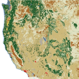
NLCD(美国国家土地覆盖数据库)是一个基于 Landsat 的 30 米土地覆盖数据库,涵盖 8 个时间段(2001 年、2004 年、2006 年、2008 年、2011 年、2013 年、2016 年和 2019 年)。您还可以在此处找到 2021 年的第九个周期。这些图片依赖于不透水性数据层来显示城市… blm landcover landuse-landcover mrlc nlcd usgs -
NLCD 2021:美国地质调查局国家土地覆盖数据库,2021 年发布
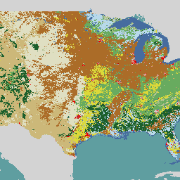
美国地质调查局 (USGS) 与多个联邦机构合作,现已开发并发布了七个国家土地覆盖数据库 (NLCD) 产品:NLCD 1992、2001、2006、2011、2016、2019 和 2021。自 2016 年发布以来,地表覆盖产品每隔 2-3 年创建一次… blm landcover landuse-landcover mrlc nlcd usgs
Datasets tagged blm in Earth Engine
[null,null,[],[],["The Bureau of Land Management (BLM) has collected over 6,000 terrestrial field plots since 2011 to assess land health through its AIM strategy. The USGS, in collaboration with federal agencies, has created the National Land Cover Database (NLCD), available for multiple epochs (2001-2021), updating land cover data. The NLCD utilizes 30-m Landsat-based imagery and is available from multiple years with two to three year intervals from 2016 onward.\n"]]