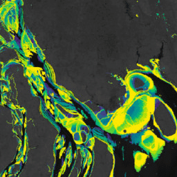
-
Murray Global Intertidal Change Classification
Der Murray Global Intertidal Change Dataset enthält globale Karten von Wattenökosystemen,die durch eine beaufsichtigte Klassifizierung von 707.528 Landsat-Archivbildern erstellt wurden. Jedes Pixel wurde anhand eines global verteilten Satzes von Trainingsdaten als Watt, stehendes Gewässer oder Sonstiges klassifiziert. Die… coastal google intertidal landsat-derived murray surface-ground-water -
Murray Global Intertidal Change Data Mask
Der Murray Global Intertidal Change Dataset enthält globale Karten von Wattenökosystemen,die durch eine beaufsichtigte Klassifizierung von 707.528 Landsat-Archivbildern erstellt wurden. Jedes Pixel wurde anhand eines global verteilten Satzes von Trainingsdaten als Watt, stehendes Gewässer oder Sonstiges klassifiziert. Die… coastal google intertidal landsat-derived murray surface-ground-water -
Murray Global Intertidal Change QA Pixel Count
Der Murray Global Intertidal Change Dataset enthält globale Karten von Wattenökosystemen,die durch eine beaufsichtigte Klassifizierung von 707.528 Landsat-Archivbildern erstellt wurden. Jedes Pixel wurde anhand eines global verteilten Satzes von Trainingsdaten als Watt, stehendes Gewässer oder Sonstiges klassifiziert. Die… coastal google intertidal landsat-derived murray surface-ground-water -
Murray Global Tidal Wetland Change v1.0 (1999–2019)
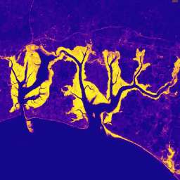
Der Murray Global Tidal Wetland Change Dataset enthält Karten der weltweiten Ausdehnung von Gezeitensümpfen und deren Veränderungen. Die Karten wurden anhand einer dreistufigen Klassifizierung entwickelt, mit der (i) die globale Verteilung von Gezeitensümpfen (definiert als Gezeitenmarsch, Gezeiten… Küsten Ökosystem Intertidalzone aus Landsat-Daten Mangroven Murray
Datasets tagged intertidal in Earth Engine
[null,null,[],[[["\u003cp\u003eThe Murray datasets provide maps of global tidal wetlands and tidal flats, including their changes over time.\u003c/p\u003e\n"],["\u003cp\u003eThese maps were created using a supervised classification of Landsat satellite imagery, categorizing areas into tidal flat, permanent water, or other.\u003c/p\u003e\n"],["\u003cp\u003eThe datasets offer insights into the extent and changes of coastal ecosystems, specifically tidal wetlands and flats, between 1999 and 2019.\u003c/p\u003e\n"],["\u003cp\u003eThey utilize a globally distributed set of training data to ensure accuracy and consistency in classification.\u003c/p\u003e\n"],["\u003cp\u003eThe "Global Tidal Wetland Change" dataset focuses on tidal marsh and mangrove ecosystems, while others like "Global Intertidal Change" focus on broader tidal flat ecosystems.\u003c/p\u003e\n"]]],["The content describes the Murray Global datasets, which map tidal wetland and intertidal flat ecosystems. The Tidal Wetland Change Dataset estimates the global distribution of tidal marshes and other tidal ecosystems. The Intertidal Change datasets classify pixels from 707,528 Landsat images into tidal flat, permanent water, or other categories. These datasets use a globally distributed training data to classify and map the global extent of intertidal areas and track changes.\n"],null,["# Datasets tagged intertidal in Earth Engine\n\n-\n\n |---------------------------------------------------------------------------------------------------------------------------------------------------------------------------------------------------------------------------------------------------------------------------------------------------------------------------------------|\n | [### Murray Global Intertidal Change Classification](/earth-engine/datasets/catalog/UQ_murray_Intertidal_v1_1_global_intertidal) |\n | The Murray Global Intertidal Change Dataset contains global maps of tidal flat ecosystems produced via a supervised classification of 707,528 Landsat Archive images. Each pixel was classified into tidal flat, permanent water or other with reference to a globally distributed set of training data. The ... |\n | [coastal](/earth-engine/datasets/tags/coastal) [google](/earth-engine/datasets/tags/google) [intertidal](/earth-engine/datasets/tags/intertidal) [landsat-derived](/earth-engine/datasets/tags/landsat-derived) [murray](/earth-engine/datasets/tags/murray) [surface-ground-water](/earth-engine/datasets/tags/surface-ground-water) |\n\n-\n\n |---------------------------------------------------------------------------------------------------------------------------------------------------------------------------------------------------------------------------------------------------------------------------------------------------------------------------------------|\n | [### Murray Global Intertidal Change Data Mask](/earth-engine/datasets/catalog/UQ_murray_Intertidal_v1_1_data_mask) |\n | The Murray Global Intertidal Change Dataset contains global maps of tidal flat ecosystems produced via a supervised classification of 707,528 Landsat Archive images. Each pixel was classified into tidal flat, permanent water or other with reference to a globally distributed set of training data. The ... |\n | [coastal](/earth-engine/datasets/tags/coastal) [google](/earth-engine/datasets/tags/google) [intertidal](/earth-engine/datasets/tags/intertidal) [landsat-derived](/earth-engine/datasets/tags/landsat-derived) [murray](/earth-engine/datasets/tags/murray) [surface-ground-water](/earth-engine/datasets/tags/surface-ground-water) |\n\n-\n\n |---------------------------------------------------------------------------------------------------------------------------------------------------------------------------------------------------------------------------------------------------------------------------------------------------------------------------------------|\n | [### Murray Global Intertidal Change QA Pixel Count](/earth-engine/datasets/catalog/UQ_murray_Intertidal_v1_1_qa_pixel_count) |\n | The Murray Global Intertidal Change Dataset contains global maps of tidal flat ecosystems produced via a supervised classification of 707,528 Landsat Archive images. Each pixel was classified into tidal flat, permanent water or other with reference to a globally distributed set of training data. The ... |\n | [coastal](/earth-engine/datasets/tags/coastal) [google](/earth-engine/datasets/tags/google) [intertidal](/earth-engine/datasets/tags/intertidal) [landsat-derived](/earth-engine/datasets/tags/landsat-derived) [murray](/earth-engine/datasets/tags/murray) [surface-ground-water](/earth-engine/datasets/tags/surface-ground-water) |\n\n-\n\n |---------------------------------------------------------------------------------------------------------------------------------------------------------------------------------------------------------------------------------------------------------------------------------------------------------------------|\n | [### Murray Global Tidal Wetland Change v1.0 (1999-2019)](/earth-engine/datasets/catalog/JCU_Murray_GIC_global_tidal_wetland_change_2019) |\n | The Murray Global Tidal Wetland Change Dataset contains maps of the global extent of tidal wetlands and their change. The maps were developed from a three stage classification that sought to (i) estimate the global distribution of tidal wetlands (defined as either tidal marsh, tidal ... |\n | [coastal](/earth-engine/datasets/tags/coastal) [ecosystem](/earth-engine/datasets/tags/ecosystem) [intertidal](/earth-engine/datasets/tags/intertidal) [landsat-derived](/earth-engine/datasets/tags/landsat-derived) [mangrove](/earth-engine/datasets/tags/mangrove) [murray](/earth-engine/datasets/tags/murray) |"]]