-
LANDFIRE BPS (Biophysical Settings) v1.4.0

LANDFIRE (LF), Landscape Fire and Resource Management Planning Tools, adalah program bersama antara program pengelolaan kebakaran hutan dari Forest Service, U.S. Department of Agriculture, Geological Survey, U.S. Department of the Interior, dan The Nature Conservancy. Lapisan LANDFIRE (LF) dibuat menggunakan … doi fire forest-biomass landfire nature-conservancy usda -
LANDFIRE ESP AK (Environmental Site Potential) v1.2.0

LANDFIRE (LF), Landscape Fire and Resource Management Planning Tools, adalah program bersama antara program pengelolaan kebakaran hutan dari Forest Service, U.S. Department of Agriculture, Geological Survey, U.S. Department of the Interior, dan The Nature Conservancy. Lapisan LANDFIRE (LF) dibuat menggunakan … doi fire forest-biomass landfire nature-conservancy usda -
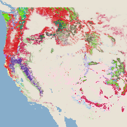
LANDFIRE ESP CONUS (Environmental Site Potential) v1.2.0

LANDFIRE (LF), Landscape Fire and Resource Management Planning Tools, adalah program bersama antara program pengelolaan kebakaran hutan dari Forest Service, U.S. Department of Agriculture, Geological Survey, U.S. Department of the Interior, dan The Nature Conservancy. Lapisan LANDFIRE (LF) dibuat menggunakan … doi fire forest-biomass landfire nature-conservancy usda -
LANDFIRE ESP HI (Environmental Site Potential) v1.2.0

LANDFIRE (LF), Landscape Fire and Resource Management Planning Tools, adalah program bersama antara program pengelolaan kebakaran hutan dari Forest Service, U.S. Department of Agriculture, Geological Survey, U.S. Department of the Interior, dan The Nature Conservancy. Lapisan LANDFIRE (LF) dibuat menggunakan … doi fire forest-biomass landfire nature-conservancy usda -
LANDFIRE EVC (Existing Vegetation Cover) v1.4.0

LANDFIRE (LF), Landscape Fire and Resource Management Planning Tools, adalah program bersama antara program pengelolaan kebakaran hutan dari Forest Service, U.S. Department of Agriculture, Geological Survey, U.S. Department of the Interior, dan The Nature Conservancy. Lapisan LANDFIRE (LF) dibuat menggunakan … doi fire forest-biomass landfire nature-conservancy usda -
LANDFIRE EVH (Existing Vegetation Height) v1.4.0

LANDFIRE (LF), Landscape Fire and Resource Management Planning Tools, adalah program bersama antara program pengelolaan kebakaran hutan dari Forest Service, U.S. Department of Agriculture, Geological Survey, U.S. Department of the Interior, dan The Nature Conservancy. Lapisan LANDFIRE (LF) dibuat menggunakan … doi fire forest-biomass landfire nature-conservancy usda -
LANDFIRE EVT (Existing Vegetation Type) v1.4.0

LANDFIRE (LF), Landscape Fire and Resource Management Planning Tools, adalah program bersama antara program pengelolaan kebakaran hutan dari Forest Service, U.S. Department of Agriculture, Geological Survey, U.S. Department of the Interior, dan The Nature Conservancy. Lapisan LANDFIRE (LF) dibuat menggunakan … doi fire forest-biomass landfire nature-conservancy usda -
LANDFIRE FRG (Fire Regime Groups) v1.2.0

LANDFIRE (LF), Landscape Fire and Resource Management Planning Tools, adalah program bersama antara program pengelolaan kebakaran hutan dari Forest Service, U.S. Department of Agriculture, Geological Survey, U.S. Department of the Interior, dan The Nature Conservancy. Rezim kebakaran historis, interval, dan … Landfire (LF) doi fire landfire nature-conservancy usda usgs -
LANDFIRE MFRI (Mean Fire Return Interval) v1.2.0

LANDFIRE (LF), Landscape Fire and Resource Management Planning Tools, adalah program bersama antara program pengelolaan kebakaran hutan dari Forest Service, U.S. Department of Agriculture, Geological Survey, U.S. Department of the Interior, dan The Nature Conservancy. Rezim kebakaran historis, interval, dan … Landfire (LF) doi fire landfire nature-conservancy usda usgs -
LANDFIRE PLS (Percent Low-severity Fire) v1.2.0

LANDFIRE (LF), Landscape Fire and Resource Management Planning Tools, adalah program bersama antara program pengelolaan kebakaran hutan dari Forest Service, U.S. Department of Agriculture, Geological Survey, U.S. Department of the Interior, dan The Nature Conservancy. Rezim kebakaran historis, interval, dan … Landfire (LF) doi fire landfire nature-conservancy usda usgs -
LANDFIRE PMS (Percent of Mixed-severity Fire) v1.2.0

LANDFIRE (LF), Landscape Fire and Resource Management Planning Tools, adalah program bersama antara program pengelolaan kebakaran hutan dari Forest Service, U.S. Department of Agriculture, Geological Survey, U.S. Department of the Interior, dan The Nature Conservancy. Rezim kebakaran historis, interval, dan … Landfire (LF) doi fire landfire nature-conservancy usda usgs -
LANDFIRE PRS (Percent of Replacement-severity Fire) v1.2.0

LANDFIRE (LF), Landscape Fire and Resource Management Planning Tools, adalah program bersama antara program pengelolaan kebakaran hutan dari Forest Service, U.S. Department of Agriculture, Geological Survey, U.S. Department of the Interior, dan The Nature Conservancy. Rezim kebakaran historis, interval, dan … Landfire (LF) doi fire landfire nature-conservancy usda usgs -
LANDFIRE SClass (Succession Classes) v1.4.0

LANDFIRE (LF), Landscape Fire and Resource Management Planning Tools, adalah program bersama antara program pengelolaan kebakaran hutan dari Forest Service, U.S. Department of Agriculture, Geological Survey, U.S. Department of the Interior, dan The Nature Conservancy. Rezim kebakaran historis, interval, dan … Landfire (LF) doi fire landfire nature-conservancy usda usgs -
LANDFIRE VCC (Vegetation Condition Class) v1.4.0

LANDFIRE (LF), Landscape Fire and Resource Management Planning Tools, adalah program bersama antara program pengelolaan kebakaran hutan dari Forest Service, U.S. Department of Agriculture, Geological Survey, U.S. Department of the Interior, dan The Nature Conservancy. Rezim kebakaran historis, interval, dan … Landfire (LF) doi fire landfire nature-conservancy usda usgs -
LANDFIRE VDep (Vegetation Departure) v1.4.0

LANDFIRE (LF), Landscape Fire and Resource Management Planning Tools, adalah program bersama antara program pengelolaan kebakaran hutan dari Forest Service, U.S. Department of Agriculture, Geological Survey, U.S. Department of the Interior, dan The Nature Conservancy. Rezim kebakaran historis, interval, dan … Landfire (LF) doi fire landfire nature-conservancy usda usgs -
USFS TreeMap v2016 (Amerika Serikat Daratan)

Produk ini adalah bagian dari rangkaian data TreeMap. Set data ini memberikan informasi spasial mendetail tentang karakteristik hutan, termasuk jumlah pohon hidup dan mati, biomassa, dan karbon di seluruh kawasan hutan di benua Amerika Serikat pada tahun 2016. TreeMap v2016 berisi satu gambar, … biomass carbon climate-change conus forest forest-biomass -
USFS TreeMap v2020
Produk ini adalah bagian dari rangkaian data TreeMap. Data ini memberikan informasi spasial mendetail tentang karakteristik hutan, termasuk jumlah pohon hidup dan mati, biomassa, dan karbon di seluruh kawasan hutan di Amerika Serikat pada tahun 2020. TreeMap v2020 berisi 22 band 30 x 30 m … aboveground biomass carbon climate-change conus forest -
USFS TreeMap v2022

Produk ini adalah bagian dari rangkaian data TreeMap. Data ini memberikan informasi spasial terperinci tentang karakteristik hutan, termasuk jumlah pohon hidup dan mati, biomassa, dan karbon di seluruh kawasan hutan di Amerika Serikat pada tahun 2022. TreeMap v2022 berisi 22 band 30 x 30 m … aboveground biomass carbon climate-change conus forest -
USGS GAP Alaska 2001

Data GAP/LANDFIRE National Terrestrial Ecosystems merepresentasikan klasifikasi vegetasi dan penutup lahan yang mendetail untuk Amerika Serikat Daratan, Alaska, Hawaii, dan Puerto Riko. GAP/LF 2011 Ecosystems for the Conterminous U.S. adalah update dari National Gap Analysis Program Land Cover Data - Version 2.2. Alaska … ecosystems gap landcover landfire usgs vegetation -
USGS GAP CONUS 2011

Data GAP/LANDFIRE National Terrestrial Ecosystems merepresentasikan klasifikasi vegetasi dan penutup lahan yang mendetail untuk Amerika Serikat Daratan, Alaska, Hawaii, dan Puerto Riko. GAP/LF 2011 Ecosystems for the Conterminous U.S. adalah update dari National Gap Analysis Program Land Cover Data - Version 2.2. Alaska … ecosystems gap landcover landfire usgs vegetation -
USGS GAP Hawaii 2001

Data GAP/LANDFIRE National Terrestrial Ecosystems merepresentasikan klasifikasi vegetasi dan penutup lahan yang mendetail untuk Amerika Serikat Daratan, Alaska, Hawaii, dan Puerto Riko. GAP/LF 2011 Ecosystems for the Conterminous U.S. adalah update dari National Gap Analysis Program Land Cover Data - Version 2.2. Alaska … ecosystems gap landcover landfire usgs vegetation -
USGS GAP Puerto Rico 2001

Data GAP/LANDFIRE National Terrestrial Ecosystems merepresentasikan klasifikasi vegetasi dan penutup lahan yang mendetail untuk Amerika Serikat Daratan, Alaska, Hawaii, dan Puerto Riko. GAP/LF 2011 Ecosystems for the Conterminous U.S. adalah update dari National Gap Analysis Program Land Cover Data - Version 2.2. Alaska … ecosystems gap landcover landfire usgs vegetation
Datasets tagged landfire in Earth Engine
[null,null,[],[],[]]