-
Estensione dinamica delle acque superficiali da Sentinel-1 (DSWx-S1) V1

Questo set di dati contiene l'estensione delle acque superficiali dinamiche di livello 3 OPERA da Sentinel-1 (DSWX-S1). DSWx-S1 fornisce una mappatura geografica quasi globale dell'estensione delle acque superficiali sulla terraferma con una risoluzione spaziale di 30 metri sul sistema di griglie del Military Grid Reference System (MGRS), con una frequenza di rivisitazione temporale compresa tra … geophysical nasa opera sentinel1-derived surface surface-ground-water -
ESA WorldCereal 10 m v100

La suite di prodotti ESA (European Space Agency) WorldCereal 10 m 2021 è costituita da mappe delle colture annuali e stagionali su scala globale e dalla relativa affidabilità. Sono stati generati nell'ambito del progetto ESA-WorldCereal. Scopri di più sui contenuti di questi prodotti e sulla metodologia utilizzata per … agriculture copernicus crop esa global landcover -
ESA WorldCereal Active Cropland 10 m v100

La suite di prodotti ESA (European Space Agency) WorldCereal Active Cropland 10 m 2021 contiene indicatori di terreni coltivati attivi stagionali su scala globale. Sono stati generati nell'ambito del progetto ESA-WorldCereal. I prodotti per i terreni coltivati attivi indicano se un pixel identificato come colture temporanee è stato coltivato attivamente … agriculture copernicus crop esa global landcover -
ESA WorldCover 10m v100

Il prodotto ESA (European Space Agency) WorldCover 10 m 2020 fornisce una mappa globale della copertura del suolo per il 2020 con una risoluzione di 10 m basata sui dati di Sentinel-1 e Sentinel-2. Il prodotto WorldCover è dotato di 11 classi di copertura del suolo ed è stato generato nell'ambito di … esa landcover landuse landuse-landcover sentinel1-derived sentinel2-derived -
ESA WorldCover 10m v200
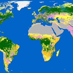
Il prodotto ESA (European Space Agency) WorldCover 10 m 2021 fornisce una mappa globale della copertura del suolo per il 2021 con una risoluzione di 10 m basata sui dati di Sentinel-1 e Sentinel-2. Il prodotto WorldCover è dotato di 11 classi di copertura del suolo ed è stato generato nell'ambito di … esa landcover landuse landuse-landcover sentinel1-derived sentinel2-derived -
EUCROPMAP

Mappe dei tipi di colture europee basate sulle osservazioni in situ di Sentinel-1 e LUCAS Copernicus 2018 per il 2018 e su una combinazione di dati ausiliari, Sentinel-1 e Sentinel-2 con le osservazioni di LUCAS Copernicus 2022 per il 2022. Basato sull'indagine in situ unica di LUCAS 2018 Copernicus, questo set di dati rappresenta il primo … agriculture crop eu jrc lucas sentinel1-derived -
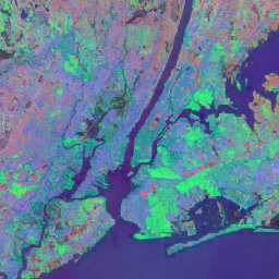
Global Seasonal Sentinel-1 Interferometric Coherence and Backscatter V2019 Backscatter

Questo set di dati è la prima rappresentazione spaziale nel suo genere delle firme di coerenza e backscatter interferometriche multi-stagionali e globali del radar ad apertura sintetica (SAR) in banda C. La copertura comprende le masse terrestri e le calotte glaciali dalle latitudini 82 gradi nord a 79 gradi sud. Il set di dati è derivato da dati multi-temporali … backscatter earth-big-data jpl nasa polarization radar -
Global Seasonal Sentinel-1 Interferometric Coherence and Backscatter V2019 Coherence

Questo set di dati è la prima rappresentazione spaziale nel suo genere delle firme di coerenza e backscatter interferometriche multi-stagionali e globali del radar ad apertura sintetica (SAR) in banda C. La copertura comprende le masse terrestri e le calotte glaciali dalle latitudini 82 gradi nord a 79 gradi sud. Il set di dati è derivato da dati multi-temporali … earth-big-data jpl nasa polarization radar sar -
Global Seasonal Sentinel-1 Interferometric Coherence and Backscatter V2019 Decay Model Parameters

Questo set di dati è la prima rappresentazione spaziale nel suo genere delle firme di coerenza e backscatter interferometriche multi-stagionali e globali del radar ad apertura sintetica (SAR) in banda C. La copertura comprende le masse terrestri e le calotte glaciali dalle latitudini 82 gradi nord a 79 gradi sud. Il set di dati è derivato da dati multi-temporali … earth-big-data jpl nasa polarization radar sar -
Global Seasonal Sentinel-1 Interferometric Coherence and Backscatter V2019 Incidence Layover Shadow

Questo set di dati è la prima rappresentazione spaziale nel suo genere delle firme di coerenza e backscatter interferometriche multi-stagionali e globali del radar ad apertura sintetica (SAR) in banda C. La copertura comprende le masse terrestri e le calotte glaciali dalle latitudini 82 gradi nord a 79 gradi sud. Il set di dati è derivato da dati multi-temporali … earth-big-data jpl nasa polarization radar sar -
OPERA Radiometric Terrain-Corrected SAR Backscatter from Sentinel-1 Static Layers V1.0

Questo prodotto contiene livelli di geometria radar statici associati al set di dati OPERA Radiometric Terrain Corrected SAR Backscatter from Sentinel-1. A causa del tubo orbitale stretto della missione S1, i livelli di geometria radar come l'angolo di incidenza, l'angolo di incidenza locale, il numero di look e il fattore di normalizzazione dell'area RTC (ANF) … jpl nasa opera sar satellite-imagery sentinel1-derived -
OPERA Radiometric Terrain-Corrected SAR Backscatter from Sentinel-1 V1.0

Questo prodotto è costituito da backscatter radar normalizzato rispetto alla topografia. Mappa i segnali relativi alle proprietà fisiche degli oggetti di scattering del suolo, come la rugosità della superficie e l'umidità del suolo e/o la vegetazione. Il prodotto OPERA RTC-S1 è derivato da Copernicus Sentinel-1 Interferometric Wide (IW) … backscatter jpl nasa opera polarization radar -
Satellite Embedding V1
Il set di dati Google Satellite Embedding è una raccolta globale di incorporamenti geospaziali appresi, pronti per l'analisi. Ogni pixel di 10 metri in questo set di dati è una rappresentazione a 64 dimensioni, o "vettore di incorporamento", che codifica le traiettorie temporali delle condizioni della superficie in corrispondenza e intorno a quel pixel misurate da varie osservazioni della Terra … annual global google landsat-derived satellite-imagery sentinel1-derived -
World Settlement Footprint 2015

Il World Settlement Footprint (WSF) 2015 è una maschera binaria con una risoluzione di 10 m che delinea l'estensione degli insediamenti umani a livello globale derivata da immagini multitemporali di Landsat-8 e Sentinel-1 del 2014-2015 (di cui sono state elaborate rispettivamente circa 217.000 e 107.000 scene). Le dinamiche temporali degli insediamenti umani … landcover landsat-derived population sentinel1-derived settlement urban
Datasets tagged sentinel1-derived in Earth Engine
[null,null,[],[],[]]