
다음 코드 샘플은 다중선을 추가하고
다음을 호출하여 3D 공간에 배치하는 방법을 보여줍니다.
addPolyline
메서드. 이 코드 샘플을 사용하려면
설정 및 앱에 3D 지도 추가의 안내에 따라 기본 3D 지도로
Android 스튜디오 프로젝트를 설정하세요. 그런 다음 MainActivity.kt 파일에 다음 코드를 추가합니다.
// Add imports
import com.google.android.gms.maps3d.model.latLngAltitude
...
// Add to the onMap3DViewReady method, after the googleMap3D object has been initialized
googleMap3D.setCamera(
camera {
center = latLngAltitude {
latitude = 40.029349
longitude = -105.300354
altitude = 1833.9
}
heading = 326.0
tilt = 75.0
range = 3757.0
}
)
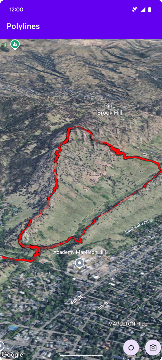
internal val trailLocations = """
40.0201040, -105.2976640
40.0201080, -105.2976450
40.0201640, -105.2975120
40.0202200, -105.2973740
40.0202500, -105.2972760
40.0202960, -105.2971410
40.0203080, -105.2970990
40.0203320, -105.2970070
40.0203640, -105.2969400
40.0203710, -105.2969250
40.0203770, -105.2969220
40.0203910, -105.2969130
40.0203940, -105.2969120
40.0204200, -105.2969130
40.0204630, -105.2968910
40.0205270, -105.2968280
40.0206030, -105.2967570
40.0206590, -105.2966100
40.0206990, -105.2964870
""".trimIndent().split("\n").map {
val (lat, lng) = it.split(",")
latLngAltitude {
latitude = lat.toDouble()
longitude = lng.toDouble()
altitude = 0.0 // The trail will be clamped to the ground
}
}
val trailPolylineOptions = polylineOptions {
coordinates = trailLocations
strokeColor = Color.RED
strokeWidth = 7.0
altitudeMode = AltitudeMode.CLAMP_TO_GROUND
zIndex = 5
drawsOccludedSegments = true
}
googleMap3D.addPolyline(trailPolylineOptions)
다중선 클릭 이벤트 수신 대기
다중선에서 클릭 이벤트를 수신 대기하려면 다중선 객체에서 setClickListener를 호출합니다. 다음 예는 다중선에 클릭 리스너를 설정하는 방법을 보여줍니다.
polyline.setClickListener {
    lifecycleScope.launch(Dispatchers.Main) {
        Toast.makeText(this@PolylinesActivity, "Hiking time!", Toast.LENGTH_SHORT).show()
    }
}
클릭 핸들러는 기본 (또는 UI) 스레드에서 실행되지 않습니다. Toast 메시지 표시와 같은 UI를 변경하려면 기본 스레드로 전환해야 합니다. Kotlin의 경우 lifecycleScope.launch(Dispatchers.Main)을 사용하면 됩니다.