Dieser Datensatz enthält 15-Tages-Vorhersagen der Wellenmodellfelder, die vom integrierten Vorhersagesystem (Integrated Forecasting System, IFS) des EZMW mit einer Auflösung von 0,25 Grad generiert werden. Wir bezeichnen diese als „Near-Realtime“ (NRT), da neue Produkte zweimal täglich nach der Veröffentlichung der Echtzeit-Vorhersagedaten des EZMW veröffentlicht werden, von denen dies eine Teilmenge ist. Daten dürfen mit entsprechender Quellenangabe verteilt und kommerziell genutzt werden.
Produkte sind in Earth Engine ab der Implementierung von Cycle 49r1 am 12.11.2024 verfügbar. Frühere Produkte sind nicht enthalten. Allgemeine Informationen zur Verwendung von ECMWF-NRT-Datasets finden Sie in der Nutzerdokumentation.
Quelldateien sind im Google Cloud Marketplace verfügbar.
Bänder
Pixelgröße 28.000 Meter
Bänder
Name
Einheiten
Min.
Max.
Pixelgröße
Beschreibung
mean_zero_crossing_wave_period_sfc
Sekunden
0,889358*
17,0074*
Meter
Die durchschnittliche Zeitspanne zwischen den Zeitpunkten, zu denen die Meeresoberfläche den mittleren Meeresspiegel überschreitet.
Die durchschnittliche Höhe des obersten Drittels der Wellen an der Meeresoberfläche, die durch Wind und Dünung entstehen. Sie stellt den vertikalen Abstand zwischen Wellenkamm und Wellental dar.
mean_wave_direction_sfc
Grad
0
360
Meter
Die mittlere Richtung von Wellen an der Meeresoberfläche relativ zum geografischen Standort des Nordpols (z. B. 0 bedeutet „aus dem Norden“ und 90 „aus dem Osten“).
peak_wave_period_sfc
Sekunden
1,03074*
23,9353*
Meter
Der Zeitraum der energiereichsten Meereswellen, die durch lokale Winde erzeugt werden und mit Dünung in Verbindung stehen. Die Wellenperiode ist die durchschnittliche Zeit, die zwei aufeinanderfolgende Wellenkämme auf der Oberfläche des Ozeans/Meeres benötigen, um einen festen Punkt zu passieren.
mean_wave_period_sfc
Sekunden
1,04071*
19,5239*
Meter
Die durchschnittliche Zeit, die zwei aufeinanderfolgende Wellenkämme auf der Oberfläche des Ozeans/Meeres benötigen, um einen festen Punkt zu passieren.
* geschätzter Mindest- oder Höchstwert
Bildattribute
Bildattribute
Name
Typ
Beschreibung
creation_day
INT
Der Tag des Monats, an dem die Prognose erstellt wurde.
creation_doy
INT
Der Tag des Jahres, an dem die Prognose erstellt wurde.
creation_hour
INT
Die Stunde des Tages, zu der die Prognose erstellt wurde.
creation_month
INT
Monat des Jahres, in dem die Prognose erstellt wurde.
creation_time
INT
Zeitpunkt in Millisekunden seit der Unix-Epoche, zu dem die Prognose erstellt wurde.
creation_year
INT
Das Jahr, in dem die Prognose erstellt wurde.
forecast_hours
INT
Die Anzahl der Stunden in der Zukunft, relativ zu creation_time, für die die Prognose erstellt wird.
forecast_time
INT
Zeitpunkt der Prognose in Millisekunden seit der Unix-Epoche.
model
STRING
Das ECMWF-Prognosemodell:
ifs: Integrated Forecasting System
aifs: Artificial Intelligence/Integrated Forecasting System
Dieser Datensatz enthält 15-Tages-Vorhersagen der Wellenmodellfelder, die vom integrierten Vorhersagesystem (Integrated Forecasting System, IFS) des EZMW mit einer Auflösung von 0,25 Grad generiert werden. Wir bezeichnen diese als „Near-Realtime“ (NRT), da neue Produkte zweimal täglich nach der Veröffentlichung der Echtzeit-Vorhersagedaten des EZMW veröffentlicht werden …
[null,null,[],[],[],null,["Dataset Availability\n: 2024-11-12T12:00:00Z--2025-08-31T12:00:00Z\n\nDataset Provider\n:\n\n\n [ECMWF](https://www.ecmwf.int/en/forecasts/datasets/open-data)\n\nCadence\n: 12 Hours\n\nTags\n:\n[climate](/earth-engine/datasets/tags/climate) [ecmwf](/earth-engine/datasets/tags/ecmwf) [forecast](/earth-engine/datasets/tags/forecast) [global](/earth-engine/datasets/tags/global) [ocean](/earth-engine/datasets/tags/ocean) \n\nDescription \nThis dataset contains 15-day forecasts of the wave model fields\ngenerated by the ECMWF Integrated Forecasting System (IFS) at 0.25 degree\nresolution. We refer to these as Near-Realtime (NRT) because new products\nare released twice a day after the release of the ECMWF realtime forecast\ndata, of which this is a subset. Data may be distributed and used\ncommercially with\n[proper attribution](https://apps.ecmwf.int/datasets/licences/general/).\n\nProducts are available in Earth Engine starting with the implementation of\n[Cycle 49r1](https://confluence.ecmwf.int/display/FCST/Implementation+of+IFS+Cycle+49r1)\non 2024-11-12; earlier products are not included. For general information\nabout how to use ECMWF NRT datasets, see their\n[user documentation](https://confluence.ecmwf.int/display/DAC/ECMWF+open+data%3A+real-time+forecasts+from+IFS+and+AIFS).\nSources files are available in the\n[Google Cloud marketplace](https://console.cloud.google.com/marketplace/product/bigquery-public-data/open-data-ecmwf).\n\nBands\n\n\n**Pixel Size**\n\n28000 meters\n\n**Bands**\n\n| Name | Units | Min | Max | Pixel Size | Description |\n|-----------------------------------------------------------|---------|-------------|-----------|------------|------------------------------------------------------------------------------------------------------------------------------------------------------------------------------------------------------------------------------------------------|\n| `mean_zero_crossing_wave_period_sfc` | seconds | 0.889358\\* | 17.0074\\* | meters | The mean length of time between occasions where the sea/ocean surface crosses mean sea level. |\n| `significant_height_of_combined_wind_waves_and_swell_sfc` | m | 0.0172079\\* | 15.7469\\* | meters | The average height of the highest third of surface ocean/sea waves generated by wind and swell. It represents the vertical distance between the wave crest and the wave trough. |\n| `mean_wave_direction_sfc` | deg | 0 | 360 | meters | The mean direction of ocean/sea surface waves relative to the geographic location of the north pole (e.g., 0 means \"coming from the north\" and 90 \"coming from the east\"). |\n| `peak_wave_period_sfc` | seconds | 1.03074\\* | 23.9353\\* | meters | The period of the most energetic ocean waves generated by local winds and associated with swell. The wave period is the average time it takes for two consecutive wave crests, on the surface of the ocean/sea, to pass through a fixed point. |\n| `mean_wave_period_sfc` | seconds | 1.04071\\* | 19.5239\\* | meters | The average time it takes for two consecutive wave crests, on the surface of the ocean/sea, to pass through a fixed point. |\n\n\\* estimated min or max value\n\nImage Properties\n\n**Image Properties**\n\n| Name | Type | Description |\n|----------------|--------|---------------------------------------------------------------------------------------------------------------------------------|\n| creation_day | INT | Day of the month when the forecast was created. |\n| creation_doy | INT | Day of the year when the forecast was created. |\n| creation_hour | INT | Hour of the day when the forecast was created. |\n| creation_month | INT | Month of the year when the forecast was created. |\n| creation_time | INT | Time, in unix epoch milliseconds, when forecast was created. |\n| creation_year | INT | Year when the forecast was created. |\n| forecast_hours | INT | Hours into the future, relative to `creation_time`, of the forecast. |\n| forecast_time | INT | Time, in unix epoch milliseconds, of the forecast. |\n| model | STRING | The ECMWF forecasting model: - ifs: Integrated Forecasting System - aifs: Artificial Intelligence/Integrated Forecasting System |\n| stream | STRING | The stream from which the variables were fetched. See the full list [here](https://codes.ecmwf.int/grib/format/mars/stream/). |\n\nTerms of Use\n\n**Terms of Use**\n\n[CC-BY-4.0](https://spdx.org/licenses/CC-BY-4.0.html)\n\nDOIs\n\n- \u003chttps://doi.org/10.21957/open-data\u003e\n\nExplore with Earth Engine **Important:** Earth Engine is a platform for petabyte-scale scientific analysis and visualization of geospatial datasets, both for public benefit and for business and government users. Earth Engine is free to use for research, education, and nonprofit use. To get started, please [register for Earth Engine access.](https://console.cloud.google.com/earth-engine)\n\nCode Editor (JavaScript) \n\n```javascript\n
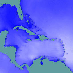
// Observe the ocean in the vicinity of the Caribbean islands and\n// Gulf coast.\nvar aoi = ee.Geometry.Polygon(\n [[\n [-100.6052734375, 31.751243295508836],\n [-100.6052734375, 6.080143483787566],\n [-57.18730468750001, 6.080143483787566],\n [-57.18730468750001, 31.751243295508836]\n ]],\n null, false);\n\n// Extract significant wave height forecasts made at noon on 2025/6/11.\nvar wave =\n ee.ImageCollection('ECMWF/NRT_FORECAST/IFS/WAVE')\n .filter(ee.Filter.eq('creation_doy', 162))\n .filter(ee.Filter.eq('creation_hour', 12))\n .sort('forecast_hours')\n .select('significant_height_of_combined_wind_waves_and_swell_sfc');\n\n// Display the observations at forecast hour 0 on the map.\nvar hour0 = wave.first().clip(aoi);\nMap.centerObject(hour0);\nMap.addLayer(hour0, {min: 0, max: 5}, 'sig height fc=0');\n\n// Animate the wave height forecasts over time.\nvar videoArgs = {\n dimensions: 540,\n region: aoi,\n framesPerSecond: 7,\n crs: 'EPSG:3857',\n min: 0,\n max: 5,\n};\nprint(ui.Thumbnail(wave, videoArgs));\n```\n[Open in Code Editor](https://code.earthengine.google.com/?scriptPath=Examples:Datasets/ECMWF/ECMWF_NRT_FORECAST_IFS_WAVE) \n[ECMWF Near-Realtime IFS Wave Forecasts](/earth-engine/datasets/catalog/ECMWF_NRT_FORECAST_IFS_WAVE) \nThis dataset contains 15-day forecasts of the wave model fields generated by the ECMWF Integrated Forecasting System (IFS) at 0.25 degree resolution. We refer to these as Near-Realtime (NRT) because new products are released twice a day after the release of the ECMWF realtime forecast data, of which this is ... \nECMWF/NRT_FORECAST/IFS/WAVE, climate,ecmwf,forecast,global,ocean \n2024-11-12T12:00:00Z/2025-08-31T12:00:00Z \n-90 -180 90 180 \nGoogle Earth Engine \nhttps://developers.google.com/earth-engine/datasets\n\n- [https://doi.org/10.21957/open-data](https://doi.org/https://www.ecmwf.int/en/forecasts/datasets/open-data)\n- [https://doi.org/10.21957/open-data](https://doi.org/https://developers.google.com/earth-engine/datasets/catalog/ECMWF_NRT_FORECAST_IFS_WAVE)"]]