Global Land Ice Measurements from Space (GLIMS) ist eine internationale Initiative, die darauf abzielt, die geschätzten 200.000 Gletscher der Welt wiederholt zu erfassen.
Ziel des Projekts ist es, ein weltweit umfassendes Inventar von Landeis zu erstellen, einschließlich Messungen der Gletscherfläche, Geometrie, Oberflächengeschwindigkeit und Schneegrenze. Für diese Analysen verwendet das GLIMS-Projekt Satellitendaten, hauptsächlich vom Advanced Spaceborne Thermal Emission and Reflection Radiometer (ASTER) und vom Landsat Enhanced Thematic Mapper Plus (ETM+), sowie historische Informationen aus Karten und Luftbildern.
Jedes Feature in diesem Dataset ist eine polygonale Grenze eines Gletschers zum Zeitpunkt der Analyse. Einige Gletscher-IDs haben im Laufe der Zeit Hunderte von unterschiedlichen Zeilen.
Dieses Dataset ist eine Momentaufnahme des Inventars der Gletschergrenzen vom 7. Juni 2023 und enthält über 1.100.000 Zeilen.
Tabellenschema
Tabellenschema
Name
Typ
Beschreibung
Analysten
STRING
Name(n) des/der Datenbeitragenden
anlys_id
DOUBLE
ID eines Gletschers zu einem bestimmten Zeitpunkt
anlys_time
STRING
Wann die Analyse durchgeführt wurde
Fläche
DOUBLE
Fläche des Gletschers in der Ebene der Kartenprojektion in Quadratkilometern
chief_affl
STRING
Zugehörigkeit des Leiters des regionalen Zentrums
db_area
DOUBLE
Wie „area“, aber vom GLIMS-Projekt neu berechnet
geog_area
STRING
Name der geografischen Region, die vom regionalen Zentrum abgedeckt wird
glac_id
STRING
Die GLIMS-Gletscher-ID
glac_name
STRING
Der Name des Gletschers. Bei etwa 80% der Zeilen ist „None“ angegeben.
glac_stat
STRING
Glacier-Status, entweder „exists“ (vorhanden) oder „None“ (kein)
Länge
DOUBLE
Länge des Gletscherumrisses in Metern
line_type
STRING
Gletschertyp, z.B. „glac_bound“ für Gletscher oder andere Werte für interne Felsen, Schneegrenzen, Wasser usw.
local_id
STRING
ID, die von der beitragenden Institution oder dem regionalen Zentrum zugewiesen wurde
max_elev
DOUBLE
Höchster Teil des Gletschers in Metern über dem Meeresspiegel
mean_elev
DOUBLE
Mittlere Höhe des Gletschers über dem Meeresspiegel in Metern
min_elev
DOUBLE
Tiefster Teil des Gletschers in Metern über dem Meeresspiegel
parent_id
STRING
ID des Gletschers, der das übergeordnete Element dieses Gletschers ist
primeclass
DOUBLE
WGMS-Gletscherklassifizierungsnummer
proc_desc
STRING
Beschreibung der Verarbeitung dieses Datensatzes
rc_id
DOUBLE
Vom regionalen Center verwendete ID
rec_status
STRING
Status des Eintrags
release_dt
STRING
Datum, an dem die Daten veröffentlicht wurden, im Format JJJJ-MM-TTTHH:mm:ss
src_date
STRING
Datum der Quellbilder, die zum Erstellen des Umrisses verwendet wurden
subm_id
DOUBLE
Die von GLIMS zugewiesene ID der Einreichung
Einreicher
STRING
Name(n) des/der Dateneinreicher(s)
wgms_id
STRING
World Glacier Monitoring Service-ID
Breite
DOUBLE
Breite des Gletschers in Metern
Nutzungsbedingungen
Nutzungsbedingungen
Bei der Erstellung von Berichten, Publikationen, neuen Datensätzen, abgeleiteten Produkten oder Diensten, die aus dem Datensatz resultieren, sollten Nutzer Folgendes angeben: GLIMS und NSIDC (2005, aktualisiert 2013): Global Land Ice Measurements from Space glacier database. Zusammengestellt und zur Verfügung gestellt von der internationalen GLIMS-Community und dem National Snow and Ice Data Center, Boulder CO, USA, doi:10.7265/N5V98602
Ein FeatureView ist eine beschleunigte Darstellung eines FeatureCollection, die nur angezeigt werden kann. Weitere Informationen finden Sie in der Dokumentation zu FeatureView.
Global Land Ice Measurements from Space (GLIMS) ist eine internationale Initiative, die darauf abzielt, die geschätzten 200.000 Gletscher der Welt regelmäßig zu erfassen. Ziel des Projekts ist es, ein weltweit umfassendes Inventar von Landeis zu erstellen, einschließlich Messungen der Gletscherfläche, Geometrie, Oberflächengeschwindigkeit und Schneegrenze. Um diese Analysen durchzuführen, …
[null,null,[],[[["\u003cp\u003e\u003cstrong\u003eCaution:\u003c/strong\u003e This dataset has been replaced by a newer version, GLIMS/20230607.\u003c/p\u003e\n"],["\u003cp\u003eGLIMS is an international project creating a global inventory of glacier boundaries, including measurements of glacier area, geometry, velocity, and snow line elevation.\u003c/p\u003e\n"],["\u003cp\u003eThe dataset comprises over 1,100,000 rows, representing glacier boundaries primarily derived from ASTER and Landsat satellite data.\u003c/p\u003e\n"],["\u003cp\u003eEach feature in the dataset represents a glacier's polygonal boundary at the time of analysis, with attributes like area, elevation, and source imagery date.\u003c/p\u003e\n"],["\u003cp\u003eUsers of this dataset for publications or derived products should cite GLIMS and NSIDC, providing the associated DOI.\u003c/p\u003e\n"]]],[],null,["# GLIMS Current: Global Land Ice Measurements From Space\n\nDataset Availability\n: 1750-01-01T00:00:00Z--2023-06-07T00:00:00Z\n\nDataset Provider\n:\n\n\n [National Snow and Ice Data Center (NSDIC)](https://www.glims.org)\n\nTags\n:\n[cryosphere](/earth-engine/datasets/tags/cryosphere) [glacier](/earth-engine/datasets/tags/glacier) [glims](/earth-engine/datasets/tags/glims) [ice](/earth-engine/datasets/tags/ice) [landcover](/earth-engine/datasets/tags/landcover) [nasa](/earth-engine/datasets/tags/nasa) [nsidc](/earth-engine/datasets/tags/nsidc) [snow](/earth-engine/datasets/tags/snow) [table](/earth-engine/datasets/tags/table) \n\n#### Description\n\nGlobal Land Ice Measurements from Space (GLIMS) is\nan international initiative with the goal of repeatedly surveying\nthe world's estimated 200,000 glaciers.\n\nThe project seeks\nto create a globally comprehensive inventory of land ice, including\nmeasurements of glacier area, geometry, surface velocity, and\nsnow line elevation. To perform these analyses, the GLIMS project\nuses satellite data, primarily from the Advanced Spaceborne Thermal\nEmission and Reflection Radiometer (ASTER) and the Landsat Enhanced\nThematic Mapper Plus (ETM+), as well as historical information\nderived from maps and aerial photographs.\n\nEach feature in this dataset is a polygonal boundary of a glacier at the\ntime of analysis. A few glacier IDs have hundreds of distinct rows over\ntime.\n\nThis dataset is a snapshot of the inventory of glacier boundaries as of\nJune 7, 2023, providing over 1,100,000 rows.\n\n### Table Schema\n\n**Table Schema**\n\n| Name | Type | Description |\n|------------|--------|--------------------------------------------------------------------------------------------------------------------------|\n| analysts | STRING | Name(s) of data contributor(s) |\n| anlys_id | DOUBLE | ID of a glacier at a particular time |\n| anlys_time | STRING | When the analysis was done |\n| area | DOUBLE | Area of the glacier in the plane of the map projection in square kilometers |\n| chief_affl | STRING | Affiliation of the chief of the regional center |\n| db_area | DOUBLE | Same as 'area', but recomputed by the GLIMS project |\n| geog_area | STRING | Name of geographic region covered by the regional center |\n| glac_id | STRING | The GLIMS glacier ID |\n| glac_name | STRING | The glacier name. \\~80% of the rows equal 'None' |\n| glac_stat | STRING | Glacier status, either 'exists' or 'None' |\n| length | DOUBLE | Length of the glacier perimeter in meters |\n| line_type | STRING | Glacier record type, e.g. 'glac_bound' for glaciers, or other values for internal rocks, snowlines, water features, etc. |\n| local_id | STRING | ID assigned by the contributing institution or regional center |\n| max_elev | DOUBLE | Highest part of the glacier, in meters above sea level |\n| mean_elev | DOUBLE | Mean elevation of the glacier, in meters above sea level |\n| min_elev | DOUBLE | Lowest part of the glacier, in meters above sea level |\n| parent_id | STRING | ID of the glacier that is the parent of this glacier |\n| primeclass | DOUBLE | WGMS glacier classification number |\n| proc_desc | STRING | Description of processing done on this record |\n| rc_id | DOUBLE | ID used by the regional center |\n| rec_status | STRING | Record status |\n| release_dt | STRING | Date data was released, in YYYY-MM-ddTHH:mm:ss format |\n| src_date | STRING | Date of source imagery used to create the outline |\n| subm_id | DOUBLE | The submission ID assigned by GLIMS |\n| submitters | STRING | Name(s) of data submitter(s) |\n| wgms_id | STRING | World Glacier Monitoring Service ID |\n| width | DOUBLE | Width of the glacier in meters |\n\n### Terms of Use\n\n**Terms of Use**\n\nFor the creation of any reports, publications, new\ndata sets, derived products, or services resulting from the data\nset, users should cite: GLIMS and NSIDC (2005, updated 2013): Global\nLand Ice Measurements from Space glacier database. Compiled and\nmade available by the international GLIMS community and the National\nSnow and Ice Data Center, Boulder CO, U.S.A.,\n[doi:10.7265/N5V98602](https://doi.org/10.7265/N5V98602)\n\n### DOIs\n\n- \u003chttps://doi.org/10.7265/N5V98602\u003e\n\n### Explore with Earth Engine\n\n| **Important:** Earth Engine is a platform for petabyte-scale scientific analysis and visualization of geospatial datasets, both for public benefit and for business and government users. Earth Engine is free to use for research, education, and nonprofit use. To get started, please [register for Earth Engine access.](https://console.cloud.google.com/earth-engine)\n\n### Code Editor (JavaScript)\n\n```javascript\n
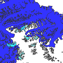
var dataset = ee.FeatureCollection('GLIMS/current');\nvar visParams = {\n palette: ['gray', 'cyan', 'blue'],\n min: 0.0,\n max: 10.0,\n opacity: 0.8,\n};\nvar image = ee.Image().float().paint(dataset, 'area');\nMap.setCenter(-35.618, 66.743, 7);\nMap.addLayer(image, visParams, 'GLIMS/current');\nMap.addLayer(dataset, null, 'for Inspector', false);\n```\n[Open in Code Editor](https://code.earthengine.google.com/?scriptPath=Examples:Datasets/GLIMS/GLIMS_current)\n\n### Visualize as a FeatureView\n\n\nA `FeatureView` is a view-only, accelerated representation of a\n`FeatureCollection`. For more details, visit the\n[`FeatureView` documentation.](/earth-engine/guides/featureview_overview)\n| **Important:** Earth Engine is a platform for petabyte-scale scientific analysis and visualization of geospatial datasets, both for public benefit and for business and government users. Earth Engine is free to use for research, education, and nonprofit use. To get started, please [register for Earth Engine access.](https://console.cloud.google.com/earth-engine)\n\n### Code Editor (JavaScript)\n\n```javascript\nvar fvLayer = ui.Map.FeatureViewLayer('GLIMS/current_FeatureView');\n\nvar visParams = {\n color: {\n property: 'area',\n mode: 'linear',\n palette: ['gray', 'cyan', 'blue'],\n min: 0.0,\n max: 10.0\n },\n opacity: 0.8,\n polygonStrokeOpacity: 0\n};\n\nfvLayer.setVisParams(visParams);\nfvLayer.setName('GLIMS/current');\n\nMap.setCenter(-35.618, 66.743, 7);\nMap.add(fvLayer);\n```\n[Open in Code Editor](https://code.earthengine.google.com/?scriptPath=Examples:Datasets/GLIMS/GLIMS_current_FeatureView) \n[GLIMS Current: Global Land Ice Measurements From Space](/earth-engine/datasets/catalog/GLIMS_current) \nGlobal Land Ice Measurements from Space (GLIMS) is an international initiative with the goal of repeatedly surveying the world's estimated 200,000 glaciers. The project seeks to create a globally comprehensive inventory of land ice, including measurements of glacier area, geometry, surface velocity, and snow line elevation. To perform these analyses, ... \nGLIMS/current, cryosphere,glacier,glims,ice,landcover,nasa,nsidc,snow,table \n1750-01-01T00:00:00Z/2023-06-07T00:00:00Z \n-90 -180 90 180 \nGoogle Earth Engine \nhttps://developers.google.com/earth-engine/datasets\n\n- [https://doi.org/10.7265/N5V98602](https://doi.org/https://www.glims.org)\n- [https://doi.org/10.7265/N5V98602](https://doi.org/https://developers.google.com/earth-engine/datasets/catalog/GLIMS_current)"]]