- Dataset-Verfügbarkeit
- 2012-06-03T00:00:00Z–2020-09-03T23:59:59Z
- Dataset-Anbieter
- University of Minnesota Polar Geospatial Center
- Tags
Beschreibung
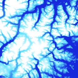
ArcticDEM ist eine öffentlich-private Initiative der National Geospatial-Intelligence Agency (NGA) und der National Science Foundation (NSF), um automatisch ein hochauflösendes, hochwertiges digitales Oberflächenmodell (DSM) der Arktis zu erstellen. Dazu werden optische Stereobilder, Hochleistungs-Computing und Open-Source-Photogrammetrie-Software verwendet. Dazu gehören Vegetation, Baumkronen, Gebäude und andere von Menschen geschaffene Oberflächenmerkmale. Das 2‑m-Asset ist aufgrund von Projektionsunterschieden zwischen den Streifen eine Sammlung von Streifen und kein einzelnes Mosaik.
Mosaik-DEM-Dateien werden aus den besten Strip-DEM-Dateien zusammengestellt, die so kombiniert und weichgezeichnet wurden, dass Lücken und Artefakte an den Rändern reduziert werden. Gefilterte IceSAT-Altimetriedaten wurden auf die Rasterdateien angewendet, um die absolute Genauigkeit zu verbessern.
Diese Version 4.1-Mosaike enthalten zusätzliche Rasterbänder: „count“, „mad“, „mindate“ und „maxdate“, um Informationen zur Datenherkunft und ‑unsicherheit bereitzustellen.
Bänder
Pixelgröße
2 Meter
Bänder
| Name | Einheiten | Min. | Max. | Pixelgröße | Beschreibung |
|---|---|---|---|---|---|
elevation |
m | –416,45* | 5971,24* | Meter | Höhe |
count |
Meter | Anzahl der DEM-Quellen, die zur Berechnung des Höhenwerts für dieses Pixel verwendet wurden. |
|||
mad |
m | Meter | Mittlere absolute Abweichung des Stapels von Quelldatasets vom mittleren Höhenwert. |
||
mindate |
Meter | Das früheste Datum der DEMs (Digital Elevation Models) der Quelle, die zum Erstellen des Mosaiks verwendet wurden, als Anzahl der Tage seit dem 1. Januar 2000. |
|||
maxdate |
Meter | Das letzte Datum der DEMs der Quelle, die zum Erstellen des Mosaiks verwendet wurden, als Anzahl der Tage seit dem 1. Januar 2000. |
|||
datamask |
Meter | Die Datenmaske gibt an , ob die Höhe 0 oder 1 war. Dabei steht 0 für „Gefüllt/mit einem anderen Dataset zusammengeführt“ oder „Als NoData in den Schritten der Qualitätskontrolle maskiert“. 1 steht für die Ausgabe von SETSM, dem Softwarepaket der Ohio State University für die Oberflächenextraktion mit TIN-basierter Minimierung des Suchraums. |
Nutzungsbedingungen
Nutzungsbedingungen
Die Richtlinie der National Science Foundation (der primären Finanzierungsquelle von PGC) schreibt vor, dass Forscher die Unterstützung durch die NSF in allen Publikationen, Webseiten und Medieninterviews anerkennen müssen.
Wenn Nutzer PGC-Daten in Earth Engine verwenden, stimmen sie zu, PGC und die Förderung durch die NSF zu zitieren. Die ursprüngliche Quelle aller von PGC bereitgestellten Drittanbieterdaten muss ebenfalls ordnungsgemäß angegeben werden.
Weitere Informationen finden Sie in der Bestätigungsrichtlinie für PGC.
Zitate
Vom Polar Geospatial Center aus Bildern von DigitalGlobe, Inc. erstellte DEMs. Porter, Claire; Morin, Paul; Howat, Ian; Noh, Myoung-Jon; Bates, Brian; Peterman, Kenneth; Keesey, Scott; Schlenk, Matthew; Gardiner, Judith; Tomko, Karen; Willis, Michael; Kelleher, Cole; Cloutier, Michael; Husby, Eric; Foga, Steven; Nakamura, Hitomi; Platson, Melisa; Wethington, Michael, Jr.; Williamson, Cathleen; Bauer, Gregory; Enos, Jeremy; Arnold, Galen; Kramer, William; Becker, Peter; Doshi, Abhijit; D'Souza, Cristelle; Cummens, Pat; Laurier, Fabien; Bojesen, Mikkel, 2018, ArcticDEM, Harvard Dataverse, V1, [Date Accessed].
DOIs
Earth Engine nutzen
Code-Editor (JavaScript)
var dataset = ee.Image('UMN/PGC/ArcticDEM/V4/2m_mosaic');

var elevationVis = {
  min: -50.0,
  max: 1000.0,
  palette: ['0d13d8', '60e1ff', 'ffffff'],
  bands: ['elevation'],
};

var countVis = {
  min: 0,
  max: 10,
  palette: [
    'black',
    'blue',
    'purple',
    'cyan',
    'green',
    'yellow',
    'red',
  ],
  bands: ['count'],
};

var madVis = {
  min: 0,
  max: 50,
  palette: [
    '006633',
    'E69800',
    'D4E157',
    'FFF59D',
  ],
  bands: ['mad'],
};

var datamaskVis = {
  min: 0,
  max: 1,
  palette: [
    'black',
    'white',
  ],
  bands: ['datamask'],
};

Map.setCenter(-63.402, 66.368, 7);

Map.addLayer(dataset, elevationVis, 'Elevation', true);
Map.addLayer(dataset, countVis, 'Data Count', false);
Map.addLayer(dataset, madVis, 'MAD', false);
Map.addLayer(dataset, datamaskVis, 'Data Mask', false);