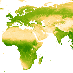
Das zugrunde liegende Dataset für dieses Produkt „Enhanced Vegetation Index (EVI)“ besteht aus MODIS-Bildern, die BRDF-korrigiert wurden (MCD43B4). Lücken wurden mithilfe des in Weiss et al. (2014) beschriebenen Ansatzes gefüllt, um fehlende Daten aufgrund von Faktoren wie Wolkenbedeckung zu eliminieren. Nach dem Schließen der Lücken wurden die Daten auf die Grenzwerte [0, 1] begrenzt, um gültige Werte zu erhalten.
Die lückenhaften 8‑Tages-Ausgaben mit einer Auflösung von etwa 1 km werden dann zeitlich aggregiert, um monatliche und jährliche Produkte zu erstellen.
Bänder
Pixelgröße 5.000 Meter
Bänder
Name
Min.
Max.
Pixelgröße
Beschreibung
Mean
0*
1*
Meter
Der Mittelwert des erweiterten Vegetationsindex für jeden aggregierten Pixel.
Weiss, D.J., P.M. Atkinson, S. Bhatt, B. Mappin, S.I., Hay, S.I. und Gething, P.W. (2014). An effective approach for gap-filling continental scale remotely sensed time-series. ISPRS Journal of Photogrammetry and Remote Sensing, 98, 106–118.
doi:10.1016/j.isprsjprs.2014.10.001
Das zugrunde liegende Dataset für dieses EVI-Produkt (Enhanced Vegetation Index) besteht aus MODIS-Bildern, die BRDF-korrigiert wurden (MCD43B4). Lücken wurden mithilfe des in Weiss et al. (2014) beschriebenen Ansatzes gefüllt, um fehlende Daten zu eliminieren, die durch Faktoren wie Wolkenbedeckung verursacht wurden. Nach dem Schließen von Lücken wurden die Daten auf die Grenzwerte [0, 1] begrenzt, um …
[null,null,[],[],[],null,["info\n\n\nThis dataset is part of a Publisher Catalog, and not managed by Google Earth Engine.\n\nContact [The Malaria Atlas Project](/earth-engine/datasets/catalog/data.malariaatlas.org@thekids.org.au)\n\nfor bugs or [view more datasets](https://developers.google.com/earth-engine/datasets/publisher/malariaatlasproject)\nfrom the The Malaria Atlas Project Catalog. [Learn more about Publisher datasets](/earth-engine/datasets/publisher). \n[](https://data.malariaatlas.org) \n\nCatalog Owner\n: The Malaria Atlas Project\n\nDataset Availability\n: 2001-02-01T00:00:00Z--2024-01-01T00:00:00Z\n\nDataset Provider\n:\n\n\n [The Malaria Atlas Project](https://www.malariaatlas.org)\n\nContact\n: [The Malaria Atlas Project](/earth-engine/datasets/catalog/data.malariaatlas.org@thekids.org.au)\n\nCadence\n: 1 Year\n\nTags\n:\n[evi](/earth-engine/datasets/tags/evi) [malariaatlasproject](/earth-engine/datasets/tags/malariaatlasproject) [map](/earth-engine/datasets/tags/map) [publisher-dataset](/earth-engine/datasets/tags/publisher-dataset) [vegetation](/earth-engine/datasets/tags/vegetation) [vegetation-indices](/earth-engine/datasets/tags/vegetation-indices) \n\nDescription \nThe underlying dataset for this Enhanced Vegetation Index (EVI)\nproduct is MODIS BRDF-corrected imagery (MCD43B4), which was gap-filled\nusing the approach outlined in Weiss et al. (2014) to eliminate missing\ndata caused by factors such as cloud cover. After gap-filling the data was clipped to thresholds of \\[0, 1\\] to ensure valid values.\n\nThe gap-filled 8-daily \\~1km outputs are then aggregated temporally to produce monthly and annual products.\n\nBands\n\n\n**Pixel Size**\n\n5000 meters\n\n**Bands**\n\n| Name | Min | Max | Pixel Size | Description |\n|--------|-----|-----|------------|----------------------------------------------------------------------------|\n| `Mean` | 0\\* | 1\\* | meters | The mean value of the Enhanced Vegetation Index for each aggregated pixel. |\n\n\\* estimated min or max value\n\nTerms of Use\n\n**Terms of Use**\n\n[CC-BY-NC-SA-4.0](https://spdx.org/licenses/CC-BY-NC-SA-4.0.html)\n\nCitations \nCitations:\n\n- Weiss, D.J., P.M. Atkinson, S. Bhatt, B. Mappin, S.I. Hay \\& P.W. Gething\n (2014) An effective approach for gap-filling continental scale remotely\n sensed time-series. ISPRS Journal of Photogrammetry and Remote Sensing,\n 98, 106-118.\n [doi:10.1016/j.isprsjprs.2014.10.001](https://doi.org/10.1016/j.isprsjprs.2014.10.001)\n\nExplore with Earth Engine **Important:** Earth Engine is a platform for petabyte-scale scientific analysis and visualization of geospatial datasets, both for public benefit and for business and government users. Earth Engine is free to use for research, education, and nonprofit use. To get started, please [register for Earth Engine access.](https://console.cloud.google.com/earth-engine)\n\nCode Editor (JavaScript) \n\n```javascript\nvar dataset = ee.ImageCollection('projects/malariaatlasproject/assets/EVI_v061/1km/Annual')\n .filter(ee.Filter.date('2018-01-01', '2023-01-01'));\nvar means = dataset.select('Mean');\nvar visParams = {\n min: 0.0,\n max: 1.0,\n palette: ['ffffff','fcd163','99b718','66a000','3e8601','207401','056201','004c00','011301'],\n};\nMap.setCenter(0, 0, 2);\nMap.addLayer(means, visParams, 'Annual EVI: Malaria Atlas Project Gap-Filled Enhanced Vegetation Index');\n```\n[Open in Code Editor](https://code.earthengine.google.com/?scriptPath=Examples:Datasets/malariaatlasproject/projects_malariaatlasproject_assets_EVI_v061_1km_Annual) \n[EVI: Malaria Atlas Project Gap-Filled Enhanced Vegetation Index (Annual 1km)](/earth-engine/datasets/catalog/projects_malariaatlasproject_assets_EVI_v061_1km_Annual) \nThe underlying dataset for this Enhanced Vegetation Index (EVI) product is MODIS BRDF-corrected imagery (MCD43B4), which was gap-filled using the approach outlined in Weiss et al. (2014) to eliminate missing data caused by factors such as cloud cover. After gap-filling the data was clipped to thresholds of \\[0, 1\\] to ... \nprojects/malariaatlasproject/assets/EVI_v061/1km/Annual, evi,malariaatlasproject,map,publisher-dataset,vegetation,vegetation-indices \n2001-02-01T00:00:00Z/2024-01-01T00:00:00Z \n-90 -180 90 180 \nGoogle Earth Engine \nhttps://developers.google.com/earth-engine/datasets\n\n- [](https://doi.org/https://www.malariaatlas.org)\n- [](https://doi.org/https://developers.google.com/earth-engine/datasets/catalog/projects_malariaatlasproject_assets_EVI_v061_1km_Annual)"]]