-
IPCC Yerüstü Biyokütlesi 1. Katman Tahminleri İçin Küresel 2020 Orman Sınıflandırması, V1
Bu veri kümesi, yaklaşık 30 m çözünürlükte 2020'deki duruma/konumuna göre sınıflandırılmış küresel orman sınıflarını sağlar. Veriler, Ulusal Sera Gazı Emisyonları İçin 2006 IPCC Kuralları'nda 2019 Refinement'da doğal ormanlarda yerüstü kuru odunsu biyokütle yoğunluğu (AGBD) için 1. Katman tahminleri oluşturmayı destekler. aboveground biomass carbon classification forest forest-biomass -
Küresel Yerüstü ve Yeraltı Biyokütle Karbon Yoğunluğu Haritaları
Bu veri kümesi, 2010 yılına ait yerüstü ve yeraltı biyokütle karbon yoğunluğu için 300 m'lik bir mekansal çözünürlükte zamansal olarak tutarlı ve uyumlu küresel haritalar sağlar. Yerüstü biyokütle haritası, ormanlık, otlak, tarım arazisi ve tundra biyokütlesinin arazi örtüsüne özgü, uzaktan algılama haritalarını birleştirir. Giriş haritaları … aboveground biomass carbon density forest forest-biomass -
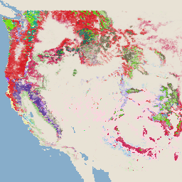
WHRC Pantropikal Ulusal Düzey Karbon Stoku Veri Kümesi
Tropikal ülkeler için 500 m'de yerüstü canlı odunsu biyokütle yoğunluğunun ulusal düzeyde haritası. Bu veri kümesi, aynı yerde yapılan saha ölçümleri, LiDAR gözlemleri ve Orta Çözünürlüklü Görüntüleme Spektroradyometresi'nden (MODIS) kaydedilen görüntülerden oluşturulmuştur. aboveground biomass carbon forest-biomass geophysical umd
Datasets tagged aboveground in Earth Engine
[null,null,[],[[["\u003cp\u003eThese datasets offer global and pantropical maps of biomass carbon density, primarily focusing on aboveground biomass.\u003c/p\u003e\n"],["\u003cp\u003eThey utilize a variety of data sources, including remotely sensed imagery, field measurements, and LiDAR observations, to provide estimates at various spatial resolutions (30m, 300m, 500m).\u003c/p\u003e\n"],["\u003cp\u003eOne dataset specifically supports the IPCC's aboveground biomass estimation methodology for national greenhouse gas inventories.\u003c/p\u003e\n"],["\u003cp\u003eThe datasets cover different time periods, including a temporally consistent view for 2010 and forest classifications for 2020.\u003c/p\u003e\n"]]],[],null,["# Datasets tagged aboveground in Earth Engine\n\n-\n\n |---------------------------------------------------------------------------------------------------------------------------------------------------------------------------------------------------------------------------------------------------------------------------------------------------------------------------|\n | [### Global 2020 Forest Classification for IPCC Aboveground Biomass Tier 1 Estimates, V1](/earth-engine/datasets/catalog/NASA_ORNL_global_forest_classification_2020_V1) |\n | This dataset provides classes of global forests delineated by status/condition in 2020 at approximately 30m resolution. The data support generating Tier 1 estimates for Aboveground dry woody Biomass Density (AGBD) in natural forests in the 2019 Refinement to the 2006 IPCC Guidelines for National Greenhouse ... |\n | [aboveground](/earth-engine/datasets/tags/aboveground) [biomass](/earth-engine/datasets/tags/biomass) [carbon](/earth-engine/datasets/tags/carbon) [classification](/earth-engine/datasets/tags/classification) [forest](/earth-engine/datasets/tags/forest) [forest-biomass](/earth-engine/datasets/tags/forest-biomass) |\n\n-\n\n |---------------------------------------------------------------------------------------------------------------------------------------------------------------------------------------------------------------------------------------------------------------------------------------------------------------------------------------|\n | [### Global Aboveground and Belowground Biomass Carbon Density Maps](/earth-engine/datasets/catalog/NASA_ORNL_biomass_carbon_density_v1) |\n | This dataset provides temporally consistent and harmonized global maps of aboveground and belowground biomass carbon density for the year 2010 at a 300-m spatial resolution. The aboveground biomass map integrates land-cover specific, remotely sensed maps of woody, grassland, cropland, and tundra biomass. Input maps were ... |\n | [aboveground](/earth-engine/datasets/tags/aboveground) [biomass](/earth-engine/datasets/tags/biomass) [carbon](/earth-engine/datasets/tags/carbon) [density](/earth-engine/datasets/tags/density) [forest](/earth-engine/datasets/tags/forest) [forest-biomass](/earth-engine/datasets/tags/forest-biomass) |\n\n-\n\n |---------------------------------------------------------------------------------------------------------------------------------------------------------------------------------------------------------------------------------------------------------------------------------------------------------|\n | [### USFS TreeMap v2020](/earth-engine/datasets/catalog/USFS_GTAC_TreeMap_v2020) |\n | This product is part of the TreeMap data suite. It provides detailed spatial information on forest characteristics including number of live and dead trees, biomass, and carbon across the entire forested extent of the United States in 2020. TreeMap v2020 contains 22-band 30 x 30m ... |\n | [aboveground](/earth-engine/datasets/tags/aboveground) [biomass](/earth-engine/datasets/tags/biomass) [carbon](/earth-engine/datasets/tags/carbon) [climate-change](/earth-engine/datasets/tags/climate-change) [conus](/earth-engine/datasets/tags/conus) [forest](/earth-engine/datasets/tags/forest) |\n\n-\n\n |---------------------------------------------------------------------------------------------------------------------------------------------------------------------------------------------------------------------------------------------------------------------------------------------------------|\n | [### USFS TreeMap v2022](/earth-engine/datasets/catalog/USFS_GTAC_TreeMap_v2022) |\n | This product is part of the TreeMap data suite. It provides detailed spatial information on forest characteristics including number of live and dead trees, biomass, and carbon across the entire forested extent of the United States in 2022. TreeMap v2022 contains 22-band 30 x 30m ... |\n | [aboveground](/earth-engine/datasets/tags/aboveground) [biomass](/earth-engine/datasets/tags/biomass) [carbon](/earth-engine/datasets/tags/carbon) [climate-change](/earth-engine/datasets/tags/climate-change) [conus](/earth-engine/datasets/tags/conus) [forest](/earth-engine/datasets/tags/forest) |\n\n-\n\n |---------------------------------------------------------------------------------------------------------------------------------------------------------------------------------------------------------------------------------------------------------------------------------------------------------------|\n | [### WHRC Pantropical National Level Carbon Stock Dataset](/earth-engine/datasets/catalog/WHRC_biomass_tropical) |\n | A national-level map of above-ground live woody biomass density for tropical countries at 500m. This dataset was assembled from a combination of co-located field measurements, LiDAR observations, and imagery recorded from the Moderate Resolution Imaging Spectroradiometer (MODIS). |\n | [aboveground](/earth-engine/datasets/tags/aboveground) [biomass](/earth-engine/datasets/tags/biomass) [carbon](/earth-engine/datasets/tags/carbon) [forest-biomass](/earth-engine/datasets/tags/forest-biomass) [geophysical](/earth-engine/datasets/tags/geophysical) [umd](/earth-engine/datasets/tags/umd) |"]]