Introduzione
Un indicatore identifica una posizione su una mappa. Per impostazione predefinita, un indicatore utilizza un'immagine standard. Gli indicatori possono visualizzare immagini personalizzate, nel qual caso sono chiamate "icone". Gli indicatori e le icone sono oggetti di tipo Marker. Puoi impostare un'icona personalizzata all'interno del costruttore dell'indicatore o chiamando setIcon() sull'indicatore. Scopri di più sulla personalizzazione dell'immagine dell'indicatore.
In generale, gli indicatori sono un tipo di overlay. Per informazioni su altri tipi di overlay, consulta Disegno sulla mappa.
Gli indicatori sono progettati per essere interattivi. Ad esempio, per impostazione predefinita ricevono eventi 'click', quindi puoi aggiungere un listener di eventi per visualizzare una finestra informativa con informazioni personalizzate. Puoi consentire agli utenti di spostare un indicatore sulla mappa impostando la proprietà draggable dell'indicatore su true. Per maggiori informazioni sugli indicatori trascinabili, vedi
di seguito.
Aggiungi un marcatore
Il costruttore google.maps.Marker utilizza un singolo valore letterale oggetto Marker options, che specifica le proprietà iniziali dell'indicatore.
I seguenti campi sono particolarmente importanti e vengono comunemente impostati durante la creazione di un indicatore:
-
position(obbligatorio) specifica unLatLngche identifica la posizione iniziale dell'indicatore. Un modo per recuperare unLatLngè utilizzare il servizio di geocodifica. -
map(facoltativo) specifica ilMapsu cui posizionare l'indicatore. Se non specifichi la mappa durante la costruzione dell'indicatore, l'indicatore viene creato, ma non viene aggiunto né visualizzato sulla mappa. Puoi aggiungere l'indicatore in un secondo momento chiamando il metodosetMap()dell'indicatore.
Il seguente esempio aggiunge un indicatore semplice a una mappa a Uluru, nel centro dell'Australia:
TypeScript
function initMap(): void {
const myLatLng = { lat: -25.363, lng: 131.044 };
const map = new google.maps.Map(
document.getElementById("map") as HTMLElement,
{
zoom: 4,
center: myLatLng,
}
);
new google.maps.Marker({
position: myLatLng,
map,
title: "Hello World!",
});
}
declare global {
interface Window {
initMap: () => void;
}
}
window.initMap = initMap;
JavaScript
function initMap() {
const myLatLng = { lat: -25.363, lng: 131.044 };
const map = new google.maps.Map(document.getElementById("map"), {
zoom: 4,
center: myLatLng,
});
new google.maps.Marker({
position: myLatLng,
map,
title: "Hello World!",
});
}
window.initMap = initMap;
Prova Sample
Nell'esempio precedente, l'indicatore viene posizionato sulla mappa durante la costruzione dell'indicatore utilizzando la proprietà map nelle opzioni relative agli indicatori.
In alternativa, puoi aggiungere l'indicatore direttamente alla mappa utilizzando il metodo setMap() dell'indicatore, come mostrato nell'esempio seguente:
var myLatlng = new google.maps.LatLng(-25.363882,131.044922);
var mapOptions = {
  zoom: 4,
  center: myLatlng
}
var map = new google.maps.Map(document.getElementById("map"), mapOptions);

var marker = new google.maps.Marker({
    position: myLatlng,
    title:"Hello World!"
});

// To add the marker to the map, call setMap();
marker.setMap(map);
The marker's title will appear as a tooltip.
If you do not wish to pass any Marker options in the
marker's constructor, instead pass an empty object {} in the
last argument of the constructor.
Remove a marker
To remove a marker from the map, call the setMap() method
passing null as the argument.
marker.setMap(null);
Note that the above method does not delete the marker. It removes the
marker from the map. If instead you wish to delete the marker, you should
remove it from the map, and then set the marker itself to
null.
If you wish to manage a set of markers, you should create an array to hold
the markers. Using this array, you can then call setMap() on
each marker in the array in turn when you need to remove the markers. You
can delete the markers by removing them from the map and then setting the
array's length to 0, which removes all
references to the markers.
Customize a marker image
You can customize the visual appearance of markers by specifying an image file or vector-based icon to display instead of the default Google Maps pushpin icon. You can add text with a marker label, and use complex icons to define clickable regions, and set the stack order of markers.
Markers with image icons
In the most basic case, an icon can specify an image to use instead of the
default Google Maps pushpin icon. To specify such an icon, set the
marker's icon property to the URL of an image. The Maps JavaScript API will size the icon automatically.
TypeScript
// This example adds a marker to indicate the position of Bondi Beach in Sydney,
// Australia.
function initMap(): void {
const map = new google.maps.Map(
document.getElementById("map") as HTMLElement,
{
zoom: 4,
center: { lat: -33, lng: 151 },
}
);
const image =
"https://developers.google.com/maps/documentation/javascript/examples/full/images/beachflag.png";
const beachMarker = new google.maps.Marker({
position: { lat: -33.89, lng: 151.274 },
map,
icon: image,
});
}
declare global {
interface Window {
initMap: () => void;
}
}
window.initMap = initMap;
JavaScript
// This example adds a marker to indicate the position of Bondi Beach in Sydney,
// Australia.
function initMap() {
const map = new google.maps.Map(document.getElementById("map"), {
zoom: 4,
center: { lat: -33, lng: 151 },
});
const image =
"https://developers.google.com/maps/documentation/javascript/examples/full/images/beachflag.png";
const beachMarker = new google.maps.Marker({
position: { lat: -33.89, lng: 151.274 },
map,
icon: image,
});
}
window.initMap = initMap;
Prova Sample
Indicatori con icone vettoriali
Puoi utilizzare percorsi vettoriali SVG personalizzati per definire l'aspetto visivo degli indicatori. Per farlo, trasmetti un valore letterale oggetto Symbol con il percorso desiderato alla proprietà icon dell'indicatore. Puoi definire un percorso personalizzato utilizzando la notazione dei percorsi SVG oppure utilizzare uno dei percorsi predefiniti in google.maps.SymbolPath. La proprietà anchor è necessaria per la corretta visualizzazione dell'indicatore quando cambia il livello di zoom. Scopri di più sull'utilizzo dei simboli per creare icone vettoriali per gli indicatori (e le polilinee).
TypeScript
// This example uses SVG path notation to add a vector-based symbol
// as the icon for a marker. The resulting icon is a marker-shaped
// symbol with a blue fill and no border.
function initMap(): void {
const center = new google.maps.LatLng(-33.712451, 150.311823);
const map = new google.maps.Map(
document.getElementById("map") as HTMLElement,
{
zoom: 9,
center: center,
}
);
const svgMarker = {
path: "M-1.547 12l6.563-6.609-1.406-1.406-5.156 5.203-2.063-2.109-1.406 1.406zM0 0q2.906 0 4.945 2.039t2.039 4.945q0 1.453-0.727 3.328t-1.758 3.516-2.039 3.070-1.711 2.273l-0.75 0.797q-0.281-0.328-0.75-0.867t-1.688-2.156-2.133-3.141-1.664-3.445-0.75-3.375q0-2.906 2.039-4.945t4.945-2.039z",
fillColor: "blue",
fillOpacity: 0.6,
strokeWeight: 0,
rotation: 0,
scale: 2,
anchor: new google.maps.Point(0, 20),
};
new google.maps.Marker({
position: map.getCenter(),
icon: svgMarker,
map: map,
});
}
declare global {
interface Window {
initMap: () => void;
}
}
window.initMap = initMap;
JavaScript
// This example uses SVG path notation to add a vector-based symbol
// as the icon for a marker. The resulting icon is a marker-shaped
// symbol with a blue fill and no border.
function initMap() {
const center = new google.maps.LatLng(-33.712451, 150.311823);
const map = new google.maps.Map(document.getElementById("map"), {
zoom: 9,
center: center,
});
const svgMarker = {
path: "M-1.547 12l6.563-6.609-1.406-1.406-5.156 5.203-2.063-2.109-1.406 1.406zM0 0q2.906 0 4.945 2.039t2.039 4.945q0 1.453-0.727 3.328t-1.758 3.516-2.039 3.070-1.711 2.273l-0.75 0.797q-0.281-0.328-0.75-0.867t-1.688-2.156-2.133-3.141-1.664-3.445-0.75-3.375q0-2.906 2.039-4.945t4.945-2.039z",
fillColor: "blue",
fillOpacity: 0.6,
strokeWeight: 0,
rotation: 0,
scale: 2,
anchor: new google.maps.Point(0, 20),
};
new google.maps.Marker({
position: map.getCenter(),
icon: svgMarker,
map: map,
});
}
window.initMap = initMap;
Prova Sample
Etichette indicatori
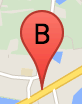
L'etichetta di un indicatore è una lettera o un numero che compare all'interno di un indicatore. L'immagine dell'indicatore in questa sezione mostra un'etichetta dell'indicatore con la lettera "B". Puoi specificare un'etichetta indicatore come stringa o come oggetto MarkerLabel che include una stringa e altre proprietà delle etichette.
Quando crei un indicatore, puoi specificare una proprietà label
nell'oggetto
MarkerOptions. In alternativa, puoi chiamare setLabel() sull'oggetto
Marker
per impostare l'etichetta su un indicatore esistente.
L'esempio seguente mostra degli indicatori etichettati quando l'utente fa clic sulla mappa:
TypeScript
// In the following example, markers appear when the user clicks on the map.
// Each marker is labeled with a single alphabetical character.
const labels = "ABCDEFGHIJKLMNOPQRSTUVWXYZ";
let labelIndex = 0;
function initMap(): void {
const bangalore = { lat: 12.97, lng: 77.59 };
const map = new google.maps.Map(
document.getElementById("map") as HTMLElement,
{
zoom: 12,
center: bangalore,
}
);
// This event listener calls addMarker() when the map is clicked.
google.maps.event.addListener(map, "click", (event) => {
addMarker(event.latLng, map);
});
// Add a marker at the center of the map.
addMarker(bangalore, map);
}
// Adds a marker to the map.
function addMarker(location: google.maps.LatLngLiteral, map: google.maps.Map) {
// Add the marker at the clicked location, and add the next-available label
// from the array of alphabetical characters.
new google.maps.Marker({
position: location,
label: labels[labelIndex++ % labels.length],
map: map,
});
}
declare global {
interface Window {
initMap: () => void;
}
}
window.initMap = initMap;
JavaScript
// In the following example, markers appear when the user clicks on the map.
// Each marker is labeled with a single alphabetical character.
const labels = "ABCDEFGHIJKLMNOPQRSTUVWXYZ";
let labelIndex = 0;
function initMap() {
const bangalore = { lat: 12.97, lng: 77.59 };
const map = new google.maps.Map(document.getElementById("map"), {
zoom: 12,
center: bangalore,
});
// This event listener calls addMarker() when the map is clicked.
google.maps.event.addListener(map, "click", (event) => {
addMarker(event.latLng, map);
});
// Add a marker at the center of the map.
addMarker(bangalore, map);
}
// Adds a marker to the map.
function addMarker(location, map) {
// Add the marker at the clicked location, and add the next-available label
// from the array of alphabetical characters.
new google.maps.Marker({
position: location,
label: labels[labelIndex++ % labels.length],
map: map,
});
}
window.initMap = initMap;
Prova Sample
Icone complesse
Puoi specificare forme complesse per indicare le aree cliccabili e specificare l'aspetto delle icone rispetto ad altri overlay (il relativo "ordine di stack"). Le icone specificate in questo modo devono impostare le proprietà icon su un oggetto di tipo Icon.
Gli oggetti Icon
definiscono un'immagine. Definiscono inoltre size dell'icona, origin dell'icona (ad esempio, se l'immagine che vuoi fa parte di un'immagine più grande in uno sprite) e anchor in cui dovrebbe trovarsi l'hotspot dell'icona (basato sull'origine).
Se utilizzi un'etichetta con un indicatore
personalizzato, puoi posizionare l'etichetta con la
proprietà labelOrigin nell'oggetto
Icon.
TypeScript
// The following example creates complex markers to indicate beaches near
// Sydney, NSW, Australia. Note that the anchor is set to (0,32) to correspond
// to the base of the flagpole.
function initMap(): void {
const map = new google.maps.Map(
document.getElementById("map") as HTMLElement,
{
zoom: 10,
center: { lat: -33.9, lng: 151.2 },
}
);
setMarkers(map);
}
// Data for the markers consisting of a name, a LatLng and a zIndex for the
// order in which these markers should display on top of each other.
const beaches: [string, number, number, number][] = [
["Bondi Beach", -33.890542, 151.274856, 4],
["Coogee Beach", -33.923036, 151.259052, 5],
["Cronulla Beach", -34.028249, 151.157507, 3],
["Manly Beach", -33.80010128657071, 151.28747820854187, 2],
["Maroubra Beach", -33.950198, 151.259302, 1],
];
function setMarkers(map: google.maps.Map) {
// Adds markers to the map.
// Marker sizes are expressed as a Size of X,Y where the origin of the image
// (0,0) is located in the top left of the image.
// Origins, anchor positions and coordinates of the marker increase in the X
// direction to the right and in the Y direction down.
const image = {
url: "https://developers.google.com/maps/documentation/javascript/examples/full/images/beachflag.png",
// This marker is 20 pixels wide by 32 pixels high.
size: new google.maps.Size(20, 32),
// The origin for this image is (0, 0).
origin: new google.maps.Point(0, 0),
// The anchor for this image is the base of the flagpole at (0, 32).
anchor: new google.maps.Point(0, 32),
};
// Shapes define the clickable region of the icon. The type defines an HTML
// <area> element 'poly' which traces out a polygon as a series of X,Y points.
// The final coordinate closes the poly by connecting to the first coordinate.
const shape = {
coords: [1, 1, 1, 20, 18, 20, 18, 1],
type: "poly",
};
for (let i = 0; i < beaches.length; i++) {
const beach = beaches[i];
new google.maps.Marker({
position: { lat: beach[1], lng: beach[2] },
map,
icon: image,
shape: shape,
title: beach[0],
zIndex: beach[3],
});
}
}
declare global {
interface Window {
initMap: () => void;
}
}
window.initMap = initMap;
JavaScript
// The following example creates complex markers to indicate beaches near
// Sydney, NSW, Australia. Note that the anchor is set to (0,32) to correspond
// to the base of the flagpole.
function initMap() {
const map = new google.maps.Map(document.getElementById("map"), {
zoom: 10,
center: { lat: -33.9, lng: 151.2 },
});
setMarkers(map);
}
// Data for the markers consisting of a name, a LatLng and a zIndex for the
// order in which these markers should display on top of each other.
const beaches = [
["Bondi Beach", -33.890542, 151.274856, 4],
["Coogee Beach", -33.923036, 151.259052, 5],
["Cronulla Beach", -34.028249, 151.157507, 3],
["Manly Beach", -33.80010128657071, 151.28747820854187, 2],
["Maroubra Beach", -33.950198, 151.259302, 1],
];
function setMarkers(map) {
// Adds markers to the map.
// Marker sizes are expressed as a Size of X,Y where the origin of the image
// (0,0) is located in the top left of the image.
// Origins, anchor positions and coordinates of the marker increase in the X
// direction to the right and in the Y direction down.
const image = {
url: "https://developers.google.com/maps/documentation/javascript/examples/full/images/beachflag.png",
// This marker is 20 pixels wide by 32 pixels high.
size: new google.maps.Size(20, 32),
// The origin for this image is (0, 0).
origin: new google.maps.Point(0, 0),
// The anchor for this image is the base of the flagpole at (0, 32).
anchor: new google.maps.Point(0, 32),
};
// Shapes define the clickable region of the icon. The type defines an HTML
// <area> element 'poly' which traces out a polygon as a series of X,Y points.
// The final coordinate closes the poly by connecting to the first coordinate.
const shape = {
coords: [1, 1, 1, 20, 18, 20, 18, 1],
type: "poly",
};
for (let i = 0; i < beaches.length; i++) {
const beach = beaches[i];
new google.maps.Marker({
position: { lat: beach[1], lng: beach[2] },
map,
icon: image,
shape: shape,
title: beach[0],
zIndex: beach[3],
});
}
}
window.initMap = initMap;
Prova Sample
Conversione di MarkerImage oggetti nel tipo Icon in corso...
Fino alla versione 3.10 dell'API Maps JavaScript, le icone complesse venivano definite come oggetti MarkerImage. Il
valore letterale oggetto Icon è stato aggiunto nella versione 3.10 e sostituisce
MarkerImage a partire dalla versione 3.11.
I valori letterali oggetto Icon supportano gli stessi parametri di
MarkerImage, consentendoti di convertire facilmente
MarkerImage in Icon rimuovendo il
costruttore, eseguendo il wrapping dei parametri precedenti tra quelli di {} e
aggiungendo i nomi di ciascun parametro. Ad esempio:
var image = new google.maps.MarkerImage(
    place.icon,
    new google.maps.Size(71, 71),
    new google.maps.Point(0, 0),
    new google.maps.Point(17, 34),
    new google.maps.Size(25, 25));
becomes
var image = {
  url: place.icon,
  size: new google.maps.Size(71, 71),
  origin: new google.maps.Point(0, 0),
  anchor: new google.maps.Point(17, 34),
  scaledSize: new google.maps.Size(25, 25)
};
Optimize markers
Optimization enhances performance by rendering many markers as a single static element. This is useful in cases where a large number of markers is required. By default, the Maps JavaScript API will decide whether a marker will be optimized. When there is a large number of markers, the Maps JavaScript API will attempt to render markers with optimization. Not all Markers can be optimized; in some situations, the Maps JavaScript API may need to render Markers without optimization. Disable optimized rendering for animated GIFs or PNGs, or when each marker must be rendered as a separate DOM element. The following example shows creating an optimized marker:
var marker = new google.maps.Marker({
    position: myLatlng,
    title:"Hello World!",
    optimized: true
});
Rendere accessibile un indicatore
Puoi rendere accessibile un indicatore aggiungendo un evento listener di clic e impostando optimized su false. Il listener dei clic fa sì che l'indicatore abbia la semantica del pulsante, a cui è possibile accedere mediante la navigazione da tastiera, gli screen reader e così via. Utilizza l'opzione title per presentare testo accessibile per un indicatore.
Nell'esempio seguente, il primo indicatore è attivo quando viene premuto il tasto Tab; puoi quindi utilizzare i tasti freccia per spostarti tra gli indicatori. Premi di nuovo Tab per continuare a spostarti tra gli altri controlli della mappa. Se un indicatore ha una finestra informativa, puoi aprirla facendo clic sull'indicatore o premendo il tasto Invio o la barra spaziatrice quando l'indicatore è selezionato. Quando la finestra informativa si chiude, lo stato attivo torna sull'indicatore associato.
TypeScript
// The following example creates five accessible and
// focusable markers.
function initMap(): void {
const map = new google.maps.Map(
document.getElementById("map") as HTMLElement,
{
zoom: 12,
center: { lat: 34.84555, lng: -111.8035 },
}
);
// Set LatLng and title text for the markers. The first marker (Boynton Pass)
// receives the initial focus when tab is pressed. Use arrow keys to
// move between markers; press tab again to cycle through the map controls.
const tourStops: [google.maps.LatLngLiteral, string][] = [
[{ lat: 34.8791806, lng: -111.8265049 }, "Boynton Pass"],
[{ lat: 34.8559195, lng: -111.7988186 }, "Airport Mesa"],
[{ lat: 34.832149, lng: -111.7695277 }, "Chapel of the Holy Cross"],
[{ lat: 34.823736, lng: -111.8001857 }, "Red Rock Crossing"],
[{ lat: 34.800326, lng: -111.7665047 }, "Bell Rock"],
];
// Create an info window to share between markers.
const infoWindow = new google.maps.InfoWindow();
// Create the markers.
tourStops.forEach(([position, title], i) => {
const marker = new google.maps.Marker({
position,
map,
title: `${i + 1}. ${title}`,
label: `${i + 1}`,
optimized: false,
});
// Add a click listener for each marker, and set up the info window.
marker.addListener("click", () => {
infoWindow.close();
infoWindow.setContent(marker.getTitle());
infoWindow.open(marker.getMap(), marker);
});
});
}
declare global {
interface Window {
initMap: () => void;
}
}
window.initMap = initMap;
JavaScript
// The following example creates five accessible and
// focusable markers.
function initMap() {
const map = new google.maps.Map(document.getElementById("map"), {
zoom: 12,
center: { lat: 34.84555, lng: -111.8035 },
});
// Set LatLng and title text for the markers. The first marker (Boynton Pass)
// receives the initial focus when tab is pressed. Use arrow keys to
// move between markers; press tab again to cycle through the map controls.
const tourStops = [
[{ lat: 34.8791806, lng: -111.8265049 }, "Boynton Pass"],
[{ lat: 34.8559195, lng: -111.7988186 }, "Airport Mesa"],
[{ lat: 34.832149, lng: -111.7695277 }, "Chapel of the Holy Cross"],
[{ lat: 34.823736, lng: -111.8001857 }, "Red Rock Crossing"],
[{ lat: 34.800326, lng: -111.7665047 }, "Bell Rock"],
];
// Create an info window to share between markers.
const infoWindow = new google.maps.InfoWindow();
// Create the markers.
tourStops.forEach(([position, title], i) => {
const marker = new google.maps.Marker({
position,
map,
title: `${i + 1}. ${title}`,
label: `${i + 1}`,
optimized: false,
});
// Add a click listener for each marker, and set up the info window.
marker.addListener("click", () => {
infoWindow.close();
infoWindow.setContent(marker.getTitle());
infoWindow.open(marker.getMap(), marker);
});
});
}
window.initMap = initMap;
Prova Sample
Animazione di un indicatore
Puoi animare gli indicatori in modo che mostrino un movimento dinamico in una varietà di circostanze diverse. Per specificare la modalità di animazione di un indicatore, utilizza
la proprietà animation dell'indicatore, di tipo
google.maps.Animation. Sono supportati i seguenti
valori Animation:
-
DROPindica che l'indicatore deve trovarsi dalla parte superiore della mappa alla posizione finale la prima volta che viene posizionato. L'animazione cesserà quando l'indicatore si fermerà eanimationtornerà anull. Questo tipo di animazione viene solitamente specificato durante la creazione diMarker. -
BOUNCEindica che l'indicatore deve rimbalzare in posizione. Un indicatore di mancato recapito continuerà a lampeggiare finché la relativa proprietàanimationnon verrà impostata esplicitamente sunull.
Puoi avviare un'animazione su un indicatore esistente chiamando
setAnimation() sull'oggetto Marker.
TypeScript
// The following example creates a marker in Stockholm, Sweden using a DROP
// animation. Clicking on the marker will toggle the animation between a BOUNCE
// animation and no animation.
let marker: google.maps.Marker;
function initMap(): void {
const map = new google.maps.Map(
document.getElementById("map") as HTMLElement,
{
zoom: 13,
center: { lat: 59.325, lng: 18.07 },
}
);
marker = new google.maps.Marker({
map,
draggable: true,
animation: google.maps.Animation.DROP,
position: { lat: 59.327, lng: 18.067 },
});
marker.addListener("click", toggleBounce);
}
function toggleBounce() {
if (marker.getAnimation() !== null) {
marker.setAnimation(null);
} else {
marker.setAnimation(google.maps.Animation.BOUNCE);
}
}
declare global {
interface Window {
initMap: () => void;
}
}
window.initMap = initMap;
JavaScript
// The following example creates a marker in Stockholm, Sweden using a DROP
// animation. Clicking on the marker will toggle the animation between a BOUNCE
// animation and no animation.
let marker;
function initMap() {
const map = new google.maps.Map(document.getElementById("map"), {
zoom: 13,
center: { lat: 59.325, lng: 18.07 },
});
marker = new google.maps.Marker({
map,
draggable: true,
animation: google.maps.Animation.DROP,
position: { lat: 59.327, lng: 18.067 },
});
marker.addListener("click", toggleBounce);
}
function toggleBounce() {
if (marker.getAnimation() !== null) {
marker.setAnimation(null);
} else {
marker.setAnimation(google.maps.Animation.BOUNCE);
}
}
window.initMap = initMap;
Prova Sample
Se hai molti indicatori, ti consigliamo di non inserirli tutti contemporaneamente sulla mappa. Puoi utilizzare setTimeout() per distribuire le
animazioni degli indicatori utilizzando uno schema come quello mostrato di seguito:
function drop() {
  for (var i =0; i < markerArray.length; i++) {
    setTimeout(function() {
      addMarkerMethod();
    }, i * 200);
  }
}
Creare un indicatore trascinabile
Per consentire agli utenti di trascinare un indicatore in una posizione diversa sulla mappa, imposta draggable su true nelle opzioni relative agli indicatori.
var myLatlng = new google.maps.LatLng(-25.363882,131.044922);
var mapOptions = {
  zoom: 4,
  center: myLatlng
}
var map = new google.maps.Map(document.getElementById("map"), mapOptions);

// Place a draggable marker on the map
var marker = new google.maps.Marker({
    position: myLatlng,
    map: map,
    draggable:true,
    title:"Drag me!"
});
Ulteriore personalizzazione degli indicatori
Per un indicatore completamente personalizzato, vedi l'esempio di popup personalizzato.
Per ulteriori estensioni della classe Marker, clustering e gestione degli indicatori e personalizzazione degli overlay, consulta le librerie open source.
Salvo quando diversamente specificato, i contenuti di questa pagina sono concessi in base alla licenza Creative Commons Attribution 4.0, mentre gli esempi di codice sono concessi in base alla licenza Apache 2.0. Per ulteriori dettagli, consulta le norme del sito di Google Developers. Java è un marchio registrato di Oracle e/o delle sue consociate.
Ultimo aggiornamento 2024-03-15 UTC.