- ডেটাসেট উপলব্ধতা
- 2018-01-01T00:00:00Z–2018-12-31T00:00:00Z
- ডেটাসেট প্রদানকারী
- ইসি জেআরসি
- ট্যাগ
বর্ণনা
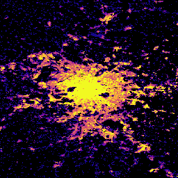
এই স্থানিক রাস্টার ডেটাসেটটি 100 মিটার রেজোলিউশনে বিল্ডিং উচ্চতার বৈশ্বিক বন্টনকে চিত্রিত করে, যা 2018 সালের জন্য উল্লেখ করা হয়েছে। বিল্ডিং উচ্চতার পূর্বাভাস দেওয়ার জন্য ব্যবহৃত ইনপুট ডেটা হল ALOS গ্লোবাল ডিজিটাল সারফেস মডেল (30 মিটার), NASA শাটল রাডার টপোগ্রাফিক মিশন ডেটা (30 মিটার), এবং গ্লোবাল ডাটা 2C-এর জন্য L-2C কম্পাইটিন পিরিয়ড। 2017-2018।
GHSL ডেটা পণ্য সম্পর্কে আরও তথ্য GHSL ডেটা প্যাকেজ 2023 রিপোর্টে পাওয়া যাবে, যেখানে বিল্ডিং উচ্চতার স্তরটিকে গড় নেট বিল্ডিং উচ্চতা (ANBH) হিসাবে উল্লেখ করা হয়েছে।
গ্লোবাল হিউম্যান সেটেলমেন্ট লেয়ার (GHSL) প্রকল্পটি ইউরোপীয় কমিশন, জয়েন্ট রিসার্চ সেন্টার, এবং আঞ্চলিক ও নগর নীতির জন্য ডিরেক্টরেট-জেনারেল দ্বারা সমর্থিত।
ব্যান্ড
পিক্সেল সাইজ
100 মিটার
ব্যান্ড
| নাম | ইউনিট | পিক্সেল সাইজ | বর্ণনা |
|---|---|---|---|
built_height | মি | মিটার | গ্রিড সেল প্রতি গড় বিল্ডিং উচ্চতা |
ব্যবহারের শর্তাবলী
ব্যবহারের শর্তাবলী
GHSL উন্মুক্ত এবং বিনামূল্যে ডেটা হিসাবে ইউরোপীয় কমিশন যৌথ গবেষণা কেন্দ্র দ্বারা উত্পাদিত হয়েছে। পুনঃব্যবহার অনুমোদিত, যদি উত্সটি স্বীকৃত হয়। আরও তথ্যের জন্য, অনুগ্রহ করে ব্যবহারের শর্তাবলী পড়ুন ( ইউরোপীয় কমিশন পুনঃব্যবহার এবং কপিরাইট বিজ্ঞপ্তি )।
উদ্ধৃতি
ডেটাসেট: পেসারেসি, মার্টিনো; Politis, Panagiotis (2023): GHS-BUILT-H R2023A - GHS বিল্ডিং উচ্চতা, AW3D30, SRTM30, এবং Sentinel2 কম্পোজিট (2018) থেকে প্রাপ্ত। ইউরোপীয় কমিশন, জয়েন্ট রিসার্চ সেন্টার (JRC) PID: http://data.europa.eu/89h/85005901-3a49-48dd-9d19-6261354f56fe doi:10.2905/85005901-3A49-48DD-9D2665159-
পদ্ধতি: পেসারেসি, মার্টিনো, মার্সেলো শিয়াভিনা, প্যানাজিওটিস পলিটিস, সার্জিও ফ্রেয়ার, কাতারজিনা ক্রাসনোদেবস্কা, জোহানেস এইচ. উহল, আলেসান্দ্রা ক্যারিওলি, এট আল। (2024)। পৃথিবী পর্যবেক্ষণ এবং জনসংখ্যা জরিপ ডেটার যৌথ মূল্যায়ন দ্বারা বিশ্বব্যাপী মানব বসতি স্তরের অগ্রগতি। ডিজিটাল আর্থের আন্তর্জাতিক জার্নাল 17(1)। doi:10.1080/17538947.2024.2390454
DOIs
আর্থ ইঞ্জিন দিয়ে অন্বেষণ করুন
কোড এডিটর (জাভাস্ক্রিপ্ট)
var image = ee.Image("JRC/GHSL/P2023A/GHS_BUILT_H/2018");
var built = image.select('built_height');
var visParams = {
  min: 0.0,
  max: 12.0,
  palette: ['000000', '0d0887', '7e03a8', 'cc4778', 'f89540', 'f0f921'],
};

Map.setCenter(2.349014, 48.864716, 10);
Map.addLayer(built, visParams, 'Average building height [m], 2018');