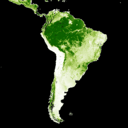
Die Landsat-VCF-Schichten (Vegetation Continuous Fields) für die Baumkronendecke enthalten Schätzungen des Prozentsatzes der horizontalen Bodenfläche in jedem 30‑m-Pixel, die von holziger Vegetation mit einer Höhe von mehr als 5 Metern bedeckt ist. Das Dataset ist für vier Epochen verfügbar, die auf die Jahre 2000, 2005, 2010 und 2015 zentriert sind. Der Datensatz basiert auf dem GFCC-Produkt „Surface Reflectance“ (GFCC30SR), das auf erweiterten GLS-Datasets (Global Land Survey) basiert. Die GLS-Datasets bestehen aus hochauflösenden Bildern des Landsat 5 Thematic Mapper (TM) und des Landsat 7 Enhanced Thematic Mapper Plus (ETM+) mit einer Auflösung von 30 Metern.
Die Baumkronendecke, die proportionale, vertikal projizierte Fläche der Vegetation (einschließlich Blätter, Stämme, Äste usw.) von holzigen Pflanzen über einer bestimmten Höhe, beeinflusst den Energie- und Wasseraustausch an Land, die Fotosynthese und Transpiration, die primäre Nettoproduktion sowie den Kohlenstoff- und Nährstofffluss. Die Baumdichte wirkt sich auch auf die Qualität des Lebensraums und die Bewegungen von Wildtieren, den Wert von Wohnimmobilien für Menschen und andere Ökosystemleistungen aus. Das kontinuierliche Klassifizierungsschema des VCF-Produkts ermöglicht eine bessere Darstellung von Landbedeckungsgradienten als herkömmliche diskrete Klassifizierungsschemata.
Für die Erkennung und Überwachung von Waldveränderungen (z.B. Entwaldung und Degradierung) ist die Baumkronendecke ein messbares Attribut, anhand dessen sich die Waldbedeckung und ihre Veränderungen definieren lassen. Anhand von Veränderungen der Baumkronendecke im Zeitverlauf lassen sich standortspezifische Verläufe von Waldveränderungen beobachten und abrufen.
Das Dataset wurde für die vier Zeiträume 2000, 2005, 2010 und 2015 erstellt. Für jeden verfügbaren WRS2-Pfad/jede verfügbare WRS2-Zeile ist ein Bild in der Sammlung enthalten.
Hinweis des Anbieters: Aufgrund des Endes der NASA MEaSUREs-Förderung werden keine kostenlosen Versionen dieses Datensatzes mehr erstellt. Aktualisierte und erweiterte Versionen sind unter www.terraPulse.com verfügbar.
Bänder
Pixelgröße 30 Meter
Bänder
Name
Einheiten
Min.
Max.
Pixelgröße
Beschreibung
tree_canopy_cover
%
0
100
Meter
Der Prozentsatz der Pixelfläche, die von Bäumen bedeckt ist.
uncertainty
Meter
RMSE für tree-canopy_cover
source_index
Meter
Identität des Quellbildes, das für das jeweilige Pixel verwendet wurde. Dies ist ein Index in das Metadaten-Array „sources“ für das jeweilige Bild. Nur für 2000, 2005 und 2010 verfügbar.
Bildattribute
Bildattribute
Name
Typ
Beschreibung
Pfad
DOUBLE
Pfad
pathrow
STRING
Pfad und Zeile
Zeile
DOUBLE
Zeile
Quellen
DOUBLE
Quellen. Nur für 2000, 2005 und 2010 verfügbar.
tree_canopy_cover_class_palette
DOUBLE
Palette für die Klasse „Überschirmung durch Baumbestand“
tree_canopy_cover_class_values
DOUBLE
Klassenwerte für die Überschirmung durch Baumbestand
Jahr
DOUBLE
Jahr
Nutzungsbedingungen
Nutzungsbedingungen
Die Rechte an geistigem Eigentum für diesen Datensatz gehören der University of Maryland, Department of Geographical Sciences und der NASA. Die Nutzung ist kostenlos, wenn eine Quellenangabe erfolgt.
Zitate
Quellenangaben:
Zitierung von Paper/Methoden: Sexton, J. O., Song, X.-P., Feng, M., Noojipady,
P., Anand, A., Huang, C., Kim, D.-H., Collins, K.M., Channan, S.,
DiMiceli, C., Townshend, J.R.G. (2013). Globale, kontinuierliche Felder der Baumkronenbedeckung mit einer Auflösung von 30 m: Landsat-basierte Reskalierung von MODIS Vegetation Continuous Fields mit lidar-basierten Schätzungen des Fehlers.
International Journal of Digital Earth, 130321031236007.
doi:10.1080/17538947.2013.786146.
Die Landsat-VCF-Baumbestands-Layer (Vegetation Continuous Fields) enthalten Schätzungen des Prozentsatzes der horizontalen Bodenfläche in jedem 30‑m-Pixel, die von holziger Vegetation mit einer Höhe von mehr als 5 Metern bedeckt ist. Der Datensatz ist für vier Epochen verfügbar, die auf die Jahre 2000, 2005, 2010 und 2015 zentriert sind. Das Dataset ist …
[null,null,[],[[["\u003cp\u003eThe NASA/MEASURES/GFCC/TC/v3 dataset provides estimates of tree canopy cover globally at 30-meter resolution, derived from Landsat imagery.\u003c/p\u003e\n"],["\u003cp\u003eData is available for four epochs centered on 2000, 2005, 2010, and 2015, representing the percentage of ground covered by woody vegetation over 5 meters tall.\u003c/p\u003e\n"],["\u003cp\u003eThe dataset is useful for monitoring forest change, habitat quality assessment, and studying various ecosystem services.\u003c/p\u003e\n"],["\u003cp\u003eFree versions are no longer being produced by NASA MEaSUREs, but updated versions are commercially available from TerraPulse.\u003c/p\u003e\n"],["\u003cp\u003eIntellectual property rights belong to the University of Maryland and NASA; usage is free with proper acknowledgement.\u003c/p\u003e\n"]]],[],null,["# Global Forest Cover Change (GFCC) Tree Cover Multi-Year Global 30m\n\nDataset Availability\n: 2000-01-01T00:00:00Z--2015-01-01T00:00:00Z\n\nDataset Provider\n:\n\n\n [NASA LP DAAC at the USGS EROS Center](https://doi.org/10.5067/MEaSUREs/GFCC/GFCC30TC.003)\n\nCadence\n: 5 Years\n\nTags\n:\n[forest](/earth-engine/datasets/tags/forest) [forest-biomass](/earth-engine/datasets/tags/forest-biomass) [glcf](/earth-engine/datasets/tags/glcf) [landsat-derived](/earth-engine/datasets/tags/landsat-derived) [nasa](/earth-engine/datasets/tags/nasa) [umd](/earth-engine/datasets/tags/umd) \n\n#### Description\n\nThe Landsat Vegetation Continuous Fields (VCF) tree cover layers contain\nestimates of the percentage of horizontal ground in each 30-m pixel covered\nby woody vegetation greater than 5 meters in height. The dataset is available\nfor four epochs centered on the years 2000, 2005, 2010 and 2015. The dataset\nis derived from the GFCC Surface Reflectance product (GFCC30SR), which is\nbased on enhanced Global Land Survey (GLS) datasets. The GLS datasets are\ncomposed of high-resolution Landsat 5 Thematic Mapper (TM) and Landsat 7\nEnhanced Thematic Mapper Plus (ETM+) images at 30 meter resolution.\n\nTree cover, the proportional, vertically projected area of vegetation\n(including leaves, stems, branches, etc.) of woody plants above a given\nheight, affects terrestrial energy and water exchanges, photosynthesis and\ntranspiration, net primary production, and carbon and nutrient fluxes. Tree\ncover also affects habitat quality and movements of wildlife, residential\nproperty value for humans, and other ecosystem services. The continuous\nclassification scheme of the VCF product enables better depiction of land\ncover gradients than traditional discrete classification schemes.\nImportantly for detection and monitoring of forest changes (e.g.,\ndeforestation and degradation), tree cover provides a measurable attribute\nupon which to define forest cover and its changes. Changes in tree cover\nover time can be used to monitor and retrieve site-specific histories of\nforest change.\n\nThe dataset has been produced for four year epochs: 2000, 2005, 2010, and\n2015 with an image in the collection for each available WRS2 path/row.\n\nDocumentation:\n\n- [User's guide](https://lpdaac.usgs.gov/documents/1371/GFCC_User_Guide_V1.pdf)\n\n- [Algorithm Theoretical Basis Document (ATBD)](https://lpdaac.usgs.gov/documents/1370/GFCC_ATBD.pdf)\n\nProvider's Note: Due to the end of NASA MEaSUREs funding, free versions of this dataset are no\nlonger being produced. Interested parties can obtain updated and expanded versions at\nwww.terraPulse.com.\n\n### Bands\n\n\n**Pixel Size**\n\n30 meters\n\n**Bands**\n\n| Name | Units | Min | Max | Pixel Size | Description |\n|---------------------|-------|-----|-----|------------|----------------------------------------------------------------------------------------------------------------------------------------------------------------|\n| `tree_canopy_cover` | % | 0 | 100 | meters | The percentage of pixel area covered by trees. |\n| `uncertainty` | | | | meters | RMSE for tree-canopy_cover |\n| `source_index` | | | | meters | Identity of source image used for the particular pixel. This is an index into the per image metadata array 'sources'. Only available for 2000, 2005, and 2010. |\n\n### Image Properties\n\n**Image Properties**\n\n| Name | Type | Description |\n|---------------------------------|--------|---------------------------------------------------|\n| path | DOUBLE | Path |\n| pathrow | STRING | Path and row |\n| row | DOUBLE | Row |\n| sources | DOUBLE | Sources. Only available for 2000, 2005, and 2010. |\n| tree_canopy_cover_class_palette | DOUBLE | Tree canopy cover class palette |\n| tree_canopy_cover_class_values | DOUBLE | Tree canopy cover class values |\n| year | DOUBLE | Year |\n\n### Terms of Use\n\n**Terms of Use**\n\nIntellectual property rights to this dataset belong to\nUniversity of Maryland, Department of Geographical Sciences and NASA. Usage\nis free if acklowedgement is made.\n\n### Citations\n\nCitations:\n\n- Paper/Methods Citation: Sexton, J. O., Song, X.-P., Feng, M., Noojipady,\n P., Anand, A., Huang, C., Kim, D.-H., Collins, K.M., Channan, S.,\n DiMiceli, C., Townshend, J.R.G. (2013). Global, 30-m resolution\n continuous fields of tree cover: Landsat-based rescaling of MODIS\n Vegetation Continuous Fields with lidar-based estimates of error.\n International Journal of Digital Earth, 130321031236007.\n [doi:10.1080/17538947.2013.786146](https://doi.org/10.1080/17538947.2013.786146).\n\n### DOIs\n\n- \u003chttps://doi.org/10.5067/MEaSUREs/GFCC/GFCC30TC.003\u003e\n\n### Explore with Earth Engine\n\n| **Important:** Earth Engine is a platform for petabyte-scale scientific analysis and visualization of geospatial datasets, both for public benefit and for business and government users. Earth Engine is free to use for research, education, and nonprofit use. To get started, please [register for Earth Engine access.](https://console.cloud.google.com/earth-engine)\n\n### Code Editor (JavaScript)\n\n```javascript\nvar dataset = ee.ImageCollection('NASA/MEASURES/GFCC/TC/v3')\n .filter(ee.Filter.date('2015-01-01', '2015-12-31'));\nvar treeCanopyCover = dataset.select('tree_canopy_cover');\nvar treeCanopyCoverVis = {\n min: 0.0,\n max: 100.0,\n palette: ['ffffff', 'afce56', '5f9c00', '0e6a00', '003800'],\n};\nMap.setCenter(-88.6, 26.4, 3);\nMap.addLayer(treeCanopyCover.mean(), treeCanopyCoverVis, 'Tree Canopy Cover');\n```\n[Open in Code Editor](https://code.earthengine.google.com/?scriptPath=Examples:Datasets/NASA/NASA_MEASURES_GFCC_TC_v3) \n[Global Forest Cover Change (GFCC) Tree Cover Multi-Year Global 30m](/earth-engine/datasets/catalog/NASA_MEASURES_GFCC_TC_v3) \nThe Landsat Vegetation Continuous Fields (VCF) tree cover layers contain estimates of the percentage of horizontal ground in each 30-m pixel covered by woody vegetation greater than 5 meters in height. The dataset is available for four epochs centered on the years 2000, 2005, 2010 and 2015. The dataset is ... \nNASA/MEASURES/GFCC/TC/v3, forest,forest-biomass,glcf,landsat-derived,nasa,umd \n2000-01-01T00:00:00Z/2015-01-01T00:00:00Z \n-90 -180 90 180 \nGoogle Earth Engine \nhttps://developers.google.com/earth-engine/datasets\n\n- [https://doi.org/10.5067/MEaSUREs/GFCC/GFCC30TC.003](https://doi.org/https://doi.org/10.5067/MEaSUREs/GFCC/GFCC30TC.003)\n- [https://doi.org/10.5067/MEaSUREs/GFCC/GFCC30TC.003](https://doi.org/https://developers.google.com/earth-engine/datasets/catalog/NASA_MEASURES_GFCC_TC_v3)"]]