- Kataloginhaber
- Forest Data Partnership
- Dataset-Verfügbarkeit
- 2020-01-01T00:00:00Z–2023-12-31T23:59:59Z
- Dataset-Anbieter
- Produced by Google for the Forest Data Partnership
- Tags
Beschreibung
Hinweis: Dieser Datensatz wurde noch nicht von Fachkollegen überprüft. Weitere Informationen finden Sie in dieser README-Datei auf GitHub.
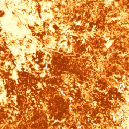
Diese Bildsammlung enthält die geschätzte Wahrscheinlichkeit pro Pixel, dass der zugrunde liegende Bereich von der Ware belegt ist. Die Wahrscheinlichkeitsschätzungen werden mit einer Auflösung von 10 Metern bereitgestellt und wurden von einem Modell für maschinelles Lernen generiert. Weitere Informationen finden Sie in der technischen Dokumentation im Forest Data Partnership-Repository auf GitHub.
Der Hauptzweck dieser Bildsammlung besteht darin, die Mission der Forest Data Partnership zu unterstützen, die darauf abzielt, den Verlust von Wäldern durch die Rohstoffproduktion zu stoppen und umzukehren, indem die globale Überwachung, die Verfolgung der Lieferkette und die Wiederherstellung gemeinsam verbessert werden.
Derzeit umfasst dieser Datensatz die folgenden Länder: Brasilien, Vietnam, Indonesien, Kolumbien, Äthiopien, Uganda, Honduras, Peru, Nicaragua und El Salvador.
Dieses Community-Datenprodukt soll sich im Laufe der Zeit weiterentwickeln, da mehr Daten aus der Community verfügbar werden und das Modell, mit dem die Karten erstellt werden, kontinuierlich verbessert wird. Wenn Sie allgemeines Feedback geben oder zusätzliche Datasets zur Verbesserung dieser Ebenen bereitstellen möchten, wenden Sie sich bitte über dieses Formular an uns.
Einschränkungen: Die Modellausgabe ist auf ausgewählte Länder als Zusammensetzungen für das Kalenderjahr 2020 und 2023 beschränkt. Nicht alle Bereiche der Ausgabe sind durch Trainingsdaten gut repräsentiert. Die Genauigkeit wird aggregiert angegeben und variiert je nach geografischer Region und den vom Nutzer ausgewählten Grenzwerten. Sensorartefakte, die auf Datenverfügbarkeit, Querstreifennichtuniformität oder Bewölkung beruhen, können in den Ausgabewahrscheinlichkeiten sichtbar sein und bei einigen Schwellenwerten zu Klassifizierungsfehlern führen.
Für kommerzielle Nutzer von Earth Engine gelten für diesen Datensatz separate Nutzungsbedingungen. Weitere Informationen finden Sie auf dem Tab „Nutzungsbedingungen“.
Bänder
Pixelgröße
10 Meter
Bänder
| Name | Min. | Max. | Pixelgröße | Beschreibung |
|---|---|---|---|---|
probability |
0 | 1 | Meter | Wahrscheinlichkeit, dass der Pixel für das angegebene Jahr Kaffeebäume enthält. |
Nutzungsbedingungen
Nutzungsbedingungen
Für nicht kommerzielle Nutzer von Earth Engine unterliegt die Nutzung des Datasets der CC-BY 4.0 NC-Lizenz und erfordert die folgende Quellenangabe: „Produced by Google for the Forest Data Partnership“.
Wenn Sie das Dataset kommerziell nutzen möchten, können Sie über dieses Formular Zugriff anfordern. Der Zugriff wird von Fall zu Fall gewährt oder verweigert. Die kommerzielle Nutzung des Datasets unterliegt den Nutzungsbedingungen für kommerzielle Datasets der Forest Data Partnership.
Enthält modifizierte Copernicus Sentinel-Daten [2015 bis heute]. Rechtliche Hinweise zu Sentinel-Daten
Zitate
Forest Data Partnership 2025) Community-Modelle 2025a Online
Earth Engine nutzen
Code-Editor (JavaScript)
Map.setCenter(-88.84, 14.57, 12);

var collection = ee.ImageCollection(
  'projects/forestdatapartnership/assets/coffee/model_2025a');

var coffee2020 = collection.filterDate('2020-01-01', '2020-12-31').mosaic().gt(0.95);
Map.addLayer(
  coffee2020.selfMask(), {min: 0.5, max: 1, palette: 'white,brown'}, 'coffee 2020');

var coffee2023 = collection.filterDate('2023-01-01', '2023-12-31').mosaic().gt(0.95);
Map.addLayer(
  coffee2023.selfMask(), {min: 0.5, max: 1, palette: 'white,green'}, 'coffee 2023');