Page Summary
-
The content includes a global relief model, ETOPO1, which integrates land topography and ocean bathymetry with ice surface and bedrock elevation bands.
-
Global Land Ice Measurements from Space (GLIMS) initiatives provide inventories of glaciers, including area, geometry, velocity, and snow line measurements.
-
Datasets for specific regions like Greenland (GIMP) offer detailed ice and ocean classification masks and glacier velocity maps.
-
The Landsat Image Mosaic of Antarctica (LIMA) provides seamless, cloudless mosaics and processed Landsat scenes of the Antarctic region.
-
Additional datasets cover land surface diagnostics (MERRA-2) and sea surface temperature (NOAA CDR OISST), some of which include ice-related information.
-
ETOPO1: Global 1 Arc-Minute Elevation
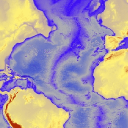
ETOPO1 is a 1 arc-minute global relief model of Earth''s surface that integrates land topography and ocean bathymetry. It was built from numerous global and regional data sets. It contains two elevation bands: ice_surface and bedrock. bedrock dem elevation elevation-topography geophysical ice -
GLIMS 2023: Global Land Ice Measurements From Space

Global Land Ice Measurements from Space (GLIMS) is an international initiative with the goal of repeatedly surveying the world's estimated 200,000 glaciers. The project seeks to create a globally comprehensive inventory of land ice, including measurements of glacier area, geometry, surface velocity, and snow line … cryosphere glacier glims ice landcover nasa -
GLIMS Current: Global Land Ice Measurements From Space
Global Land Ice Measurements from Space (GLIMS) is an international initiative with the goal of repeatedly surveying the world's estimated 200,000 glaciers. The project seeks to create a globally comprehensive inventory of land ice, including measurements of glacier area, geometry, surface velocity, and snow line … cryosphere glacier glims ice landcover nasa -
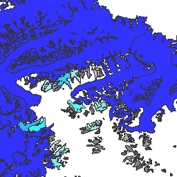
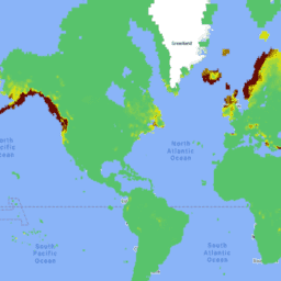
Greenland Ice & Ocean Mask - Greenland Mapping Project (GIMP)
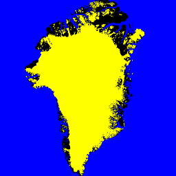
This dataset provides complete land ice and ocean classification masks at 15 m for the Greenland ice sheet. Ice cover was mapped using a combination of orthorectified panchromatic (band 8) imagery from the Landsat 7 Enhanced Thematic Mapper Plus (ETM+), distributed by the USGS, and … arctic cryosphere gimp greenland ice nasa -
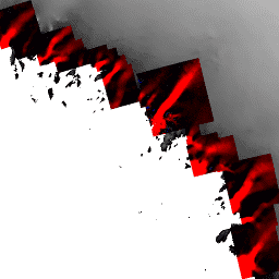
Landsat Image Mosaic of Antarctica (LIMA) - Processed Landsat Scenes (16 bit)
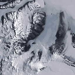
The Landsat Image Mosaic of Antarctica (LIMA) is a seamless and virtually cloudless mosaic created from processed Landsat 7 ETM+ scenes. Processed Landsat Scenes (16 bit) are Level 1Gt NLAPS scenes converted to 16 bit, processed with sun-angle correction, and converted to reflectance values (Bindschadler … antarctica ice landsat-derived lima mosaic satellite-imagery -
Landsat Image Mosaic of Antarctica (LIMA) - Processed Landsat Scenes (16 bit) Metadata
The Landsat Image Mosaic of Antarctica (LIMA) is a seamless and virtually cloudless mosaic created from processed Landsat 7 ETM+ scenes. Processed Landsat Scenes (16 bit) are Level 1Gt NLAPS scenes converted to 16 bit, processed with sun-angle correction, and converted to reflectance values (Bindschadler … antarctica ice landsat-derived lima mosaic satellite-imagery -
Landsat Image Mosaic of Antarctica (LIMA) 16-Bit Pan-Sharpened Mosaic

The Landsat Image Mosaic of Antarctica (LIMA) is a seamless and virtually cloudless mosaic created from processed Landsat 7 ETM+ scenes. This LIMA dataset is the 16-bit Intermediate LIMA. The mosaic consists of pan-sharpened normalized surface reflectance scenes (Landsat ETM+ bands 1, 2, 3, and … antarctica ice landsat-derived lima mosaic satellite-imagery -
MERRA-2 M2T1NXLND: Land Surface Diagnostics V5.12.4
M2T1NXLND (or tavg1_2d_lnd_Nx) is an hourly time-averaged data collection in Modern-Era Retrospective analysis for Research and Applications version 2 (MERRA-2). This collection consists of land surface diagnostics, such a baseflow flux, runoff, surface soil wetness, root zone soil wetness, water at surface layer, water at … climate cryosphere evaporation ice merra precipitation -
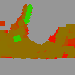
MEaSUREs Greenland Ice Velocity: Selected Glacier Site Velocity Maps from Optical Images Version 2
This dataset, part of the NASA Making Earth System Data Records for Use in Research Environments (MEaSUREs) program, consists of mean monthly velocity maps for selected glacier outlet areas. The maps are generated by tracking visible features between optical image pairs acquired by the Landsat … arctic cryosphere gimp greenland ice nasa -
NOAA CDR OISST v02r01: Optimum Interpolation Sea Surface Temperature
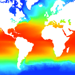
The NOAA 1/4 degree daily Optimum Interpolation Sea Surface Temperature (OISST) provides complete ocean temperature fields constructed by combining bias-adjusted observations from different platforms (satellite, ships, buoys) on a regular global grid, with gaps filled in by interpolation. Satellite data from the Advanced Very High … avhrr cdr daily ice noaa oceans