Aggiungere una polilinea a una mappa
Mantieni tutto organizzato con le raccolte
Salva e classifica i contenuti in base alle tue preferenze.
Seleziona la piattaforma:
Android
iOS
JavaScript
Il seguente esempio di codice
mostra come aggiungere una polilinea e posizionarla nello spazio 3D chiamando il metodo
addPolyline
. Per utilizzare questo esempio di codice, segui le istruzioni riportate in
Configurazione e
Aggiungere una mappa 3D all'app per configurare
il progetto Android Studio con una mappa 3D di base. Poi, aggiungi il seguente codice al file
MainActivity.kt
:
// Add imports
import com.google.android.gms.maps3d.model.latLngAltitude
...
// Add to the onMap3DViewReady method, after the googleMap3D object has been initialized
googleMap3D.setCamera(
camera {
center = latLngAltitude {
latitude = 40.029349
longitude = -105.300354
altitude = 1833.9
}
heading = 326.0
tilt = 75.0
range = 3757.0
}
)
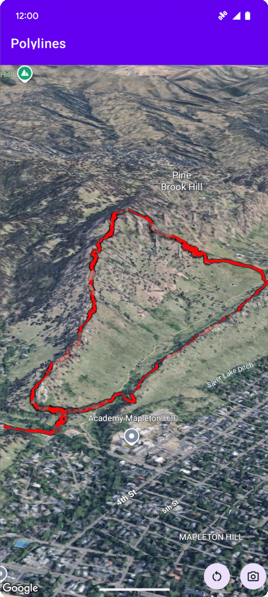
internal val trailLocations = """
40.0201040, -105.2976640
40.0201080, -105.2976450
40.0201640, -105.2975120
40.0202200, -105.2973740
40.0202500, -105.2972760
40.0202960, -105.2971410
40.0203080, -105.2970990
40.0203320, -105.2970070
40.0203640, -105.2969400
40.0203710, -105.2969250
40.0203770, -105.2969220
40.0203910, -105.2969130
40.0203940, -105.2969120
40.0204200, -105.2969130
40.0204630, -105.2968910
40.0205270, -105.2968280
40.0206030, -105.2967570
40.0206590, -105.2966100
40.0206990, -105.2964870
""".trimIndent().split("\n").map {
val (lat, lng) = it.split(",")
latLngAltitude {
latitude = lat.toDouble()
longitude = lng.toDouble()
altitude = 0.0 // The trail will be clamped to the ground
}
}
val trailPolylineOptions = polylineOptions {
coordinates = trailLocations
strokeColor = Color.RED
strokeWidth = 7.0
altitudeMode = AltitudeMode.CLAMP_TO_GROUND
zIndex = 5
drawsOccludedSegments = true
}
googleMap3D.addPolyline(trailPolylineOptions)
Salvo quando diversamente specificato, i contenuti di questa pagina sono concessi in base alla licenza Creative Commons Attribution 4.0, mentre gli esempi di codice sono concessi in base alla licenza Apache 2.0. Per ulteriori dettagli, consulta le norme del sito di Google Developers. Java è un marchio registrato di Oracle e/o delle sue consociate.
Ultimo aggiornamento 2025-08-31 UTC.
[null,null,["Ultimo aggiornamento 2025-08-31 UTC."],[],[],null,["# Add a polyline to a map\n\nSelect platform: [Android](/maps/documentation/maps-3d/android-sdk/add-polylines \"View this page for the Android platform docs.\") [iOS](/maps/documentation/maps-3d/ios-sdk/add-polylines \"View this page for the iOS platform docs.\") [JavaScript](/maps/documentation/javascript/3d/shapes-lines \"View this page for the JavaScript platform docs.\")\n\n\u003cbr /\u003e\n\n| This product or feature is Experimental (pre-GA). Pre-GA products and features might have limited support, and changes to pre-GA products and features might not be compatible with other pre-GA versions. Pre-GA Offerings are covered by the [Google\n| Maps Platform Service Specific Terms](https://cloud.google.com/maps-platform/terms/maps-service-terms). For more information, see the [launch stage descriptions](/maps/launch-stages).\n\n\nThe following code sample\ndemonstrates how to add a polyline and position it in 3D space by calling the\n[`addPolyline`](/maps/documentation/maps-3d/android-sdk/reference/com/google/android/gms/maps3d/GoogleMap3D#addPolyline(com.google.android.gms.maps3d.model.PolylineOptions))\nmethod. To use this code sample, follow the instructions in\n[Setup](/maps/documentation/maps-3d/android-sdk/setup) and\n[Add a 3D map to your app](/maps/documentation/maps-3d/android-sdk/add-a-3d-map) to set\nup your Android Studio project with a basic 3D map. Then, add the following code to the\n**`MainActivity.kt`** file: \n\n```kotlin\n// Add imports\nimport com.google.android.gms.maps3d.model.latLngAltitude\n\n...\n\n// Add to the onMap3DViewReady method, after the googleMap3D object has been initialized\ngoogleMap3D.setCamera(\n camera {\n center = latLngAltitude {\n latitude = 40.029349\n longitude = -105.300354\n altitude = 1833.9\n }\n heading = 326.0\n tilt = 75.0\n range = 3757.0\n }\n)\ninternal val trailLocations = \"\"\"\n 40.0201040, -105.2976640\n 40.0201080, -105.2976450\n 40.0201640, -105.2975120\n 40.0202200, -105.2973740\n 40.0202500, -105.2972760\n 40.0202960, -105.2971410\n 40.0203080, -105.2970990\n 40.0203320, -105.2970070\n 40.0203640, -105.2969400\n 40.0203710, -105.2969250\n 40.0203770, -105.2969220\n 40.0203910, -105.2969130\n 40.0203940, -105.2969120\n 40.0204200, -105.2969130\n 40.0204630, -105.2968910\n 40.0205270, -105.2968280\n 40.0206030, -105.2967570\n 40.0206590, -105.2966100\n 40.0206990, -105.2964870\n\"\"\".trimIndent().split(\"\\n\").map {\n val (lat, lng) = it.split(\",\")\n latLngAltitude {\n latitude = lat.toDouble()\n longitude = lng.toDouble()\n altitude = 0.0 // The trail will be clamped to the ground\n }\n}\n\nval trailPolylineOptions = polylineOptions {\n coordinates = trailLocations\n strokeColor = Color.RED\n strokeWidth = 7.0\n altitudeMode = AltitudeMode.CLAMP_TO_GROUND\n zIndex = 5\n drawsOccludedSegments = true\n}\n\ngoogleMap3D.addPolyline(trailPolylineOptions)\n```"]]