- Dostępność zbioru danych
- 1975-01-01T00:00:00Z–2030-12-31T00:00:00Z
- Dostawca zbioru danych
- EC JRC
- Tagi
Opis
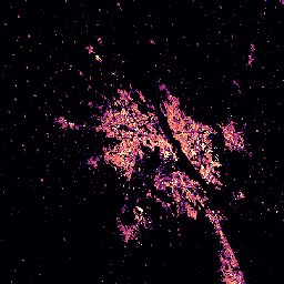
Ten zbiór danych rastrowych przedstawia globalne rozmieszczenie objętości budynków wyrażonej w metrach sześciennych na komórkę siatki o wymiarach 100 m x 100 m. Zbiór danych zawiera pomiary całkowitej objętości budynku i objętości budynku przypisanej do komórek siatki o przeważającym zastosowaniu niemieszkalnym (NRES). Szacunki są oparte na produktach built-up surface i building height.
Więcej informacji o produktach danych GHSL znajdziesz w raporcie GHSL Data Package 2023.
Projekt Global Human Settlement Layer (GHSL) jest wspierany przez Komisję Europejską, Wspólne Centrum Badawcze oraz Dyrekcję Generalną ds. Polityki Regionalnej i Miejskiej.
Pasma
Rozmiar piksela
100 metrów
Pasma
| Nazwa | Jednostki | Rozmiar piksela | Opis |
|---|---|---|---|
built_volume_total |
m^3 | metry | Całkowita objętość budynku w komórce siatki |
built_volume_nres |
m^3 | metry | Objętość budynków niemieszkalnych w poszczególnych komórkach siatki |
Warunki korzystania z usługi
Warunki korzystania z usługi
GHSL został opracowany przez Wspólne Centrum Badawcze Komisji Europejskiej jako otwarte i bezpłatne dane. Ponowne wykorzystanie jest dozwolone pod warunkiem podania źródła. Więcej informacji znajdziesz w warunkach korzystania (European Commission Reuse and Copyright Notice).
Cytaty
Zbiór danych : Pesaresi, Martino; Politis, Panagiotis (2023):GHS-BUILT-V R2023A - GHS built-up volume grids derived from joint assessment of Sentinel2, Landsat, and global DEM data, multitemporal (1975-2030). Komisja Europejska, Wspólne Centrum Badawcze (JRC) PID: http://data.europa.eu/89h/ab2f107a-03cd-47a3-85e5-139d8ec63283 doi:10.2905/AB2F107A-03CD-47A3-85E5-139D8EC63283
Metodologia : Pesaresi, Martino, Marcello Schiavina, Panagiotis Politis, Sergio Freire, Katarzyna Krasnodebska, Johannes H. Uhl, Alessandra Carioli i in. (2024). Postępy w zakresie globalnej warstwy osadnictwa ludzkiego dzięki wspólnej ocenie danych z obserwacji Ziemi i badań ankietowych populacji. International Journal of Digital Earth 17(1). doi:10.1080/17538947.2024.2390454.
DOI
Odkrywanie za pomocą Earth Engine
Edytor kodu (JavaScript)
var image_1975 = ee.Image('JRC/GHSL/P2023A/GHS_BUILT_V/1975');
var image_2020 = ee.Image('JRC/GHSL/P2023A/GHS_BUILT_V/2020');
var volume_total_1975 = image_1975.select('built_volume_total');
var volume_total_2020 = image_2020.select('built_volume_total');


var visParams = {
  min: 0,
  max: 80000,
  palette: ['000004', '51127c', 'b73779', 'fc8961', 'fcfdbf'],
};

Map.setCenter(77.156, 28.6532, 10);
Map.addLayer(volume_total_1975, visParams, 'Total building volume [m3], 1975');
Map.addLayer(volume_total_2020, visParams, 'Total building volume [m3], 2020');