- Dataset-Verfügbarkeit
- 2019-01-01T00:00:00Z–2020-01-01T00:00:00Z
- Dataset-Anbieter
- Malaria Atlas Project
- Tags
Beschreibung
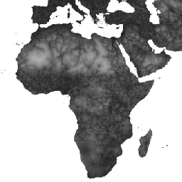
Diese globale Karte zur Erreichbarkeit gibt die Reisezeit (in Minuten) zum nächstgelegenen Krankenhaus oder zur nächstgelegenen Klinik für alle Gebiete zwischen 85° N und 60° S für das nominelle Jahr 2019 an. Sie umfasst auch die Reisezeit für Fußgänger, bei der nur nicht motorisierte Transportmittel verwendet werden.
Die umfangreichen Datenerhebungen von OpenStreetMap, Google Maps und akademischen Forschern wurden genutzt, um die bisher vollständigste Sammlung von Standorten von Gesundheitseinrichtungen zusammenzustellen. Diese Karte wurde in Zusammenarbeit von MAP (University of Oxford), Telethon Kids Institute (Perth, Australien), Google und der Universität Twente (Niederlande) erstellt.
Dieses Projekt baut auf früheren Arbeiten von Weiss et al. (2018) auf (doi:10.1038/nature25181). Weiss et al. (2018) verwendeten Datasets für Straßen (die erste globale Nutzung von Open Street Map- und Google-Straßendatasets), Eisenbahnen, Flüsse, Seen, Ozeane, topografische Bedingungen (Hangneigung und Höhe), Landbedeckungstypen und Landesgrenzen. Diesen Datasets wurde jeweils eine oder mehrere Geschwindigkeiten für die Zeit zugewiesen, die zum Durchqueren jedes Pixels dieses Typs erforderlich ist. Die Datasets wurden dann kombiniert, um eine „Reibungsfläche“ zu erstellen: eine Karte, auf der jedem Pixel eine nominelle Gesamtgeschwindigkeit basierend auf den Typen zugewiesen wird, die in diesem Pixel vorkommen. Für das aktuelle Projekt wurde eine aktualisierte Reibungsfläche erstellt, um die jüngsten Verbesserungen bei OSM-Straßendaten zu berücksichtigen.
Algorithmen für den kostengünstigsten Pfad (in Google Earth Engine und für Gebiete mit hohem Breitengrad in R ausgeführt) wurden in Verbindung mit dieser Reibungsfläche verwendet, um die Reisezeit von allen Standorten zur nächstgelegenen (zeitlich) Gesundheitseinrichtung zu berechnen. Für das Dataset zu Gesundheitseinrichtungen wurden Standortdaten aus zwei der größten globalen Datenbanken verwendet: (1) OSM-Daten, die unter www.healthsites.io zusammengestellt und zum Download zur Verfügung gestellt wurden, und (2) Daten, die aus Google Maps extrahiert wurden. Die globalen Datasets wurden mit kürzlich für Afrika und Australien veröffentlichten Standorten von Einrichtungen auf kontinentaler Ebene ergänzt. Um Vergleiche zwischen Datenquellen zu ermöglichen, wurden nur Einrichtungen verwendet, die als Krankenhäuser und Kliniken definiert sind. Mehrere Punkte innerhalb desselben Pixels wurden zusammengeführt, um der Auflösung der Analyse zu entsprechen, die durch die ausgewählte Rasterdarstellung der Erdoberfläche definiert wird. Jeder Pixel in der resultierenden Karte zur Barrierefreiheit stellt also die modellierte kürzeste Zeit (in Minuten) von diesem Ort zu einem Krankenhaus oder einer Klinik dar.
Die Quellenangaben für das Quell-Dataset sind im zugehörigen Artikel beschrieben.
Bänder
Pixelgröße
927,67 Meter
Bänder
| Name | Einheiten | Min. | Max. | Pixelgröße | Beschreibung |
|---|---|---|---|---|---|
accessibility |
Min. | 0 | 41504.1 | Meter | Fahrzeit zum nächsten Krankenhaus oder zur nächsten Klinik. |
accessibility_walking_only |
Min. | 0 | 138893 | Meter | Reisezeit zum nächstgelegenen Krankenhaus oder zur nächstgelegenen Klinik mit nicht motorisierten Verkehrsmitteln. |
Nutzungsbedingungen
Nutzungsbedingungen
Dieses Werk wurde unter einer Creative Commons Attribution 4.0 International License veröffentlicht.
Zitate
D.J. Weiss, A. Nelson, C.A. Vargas-Ruiz, K. Gligorić, S. Bavadekar, E. Gabrilovich, A. Bertozzi-Villa, J. Rozier, H.S. Gibson, T. Shekel, C. Kamath, A. Lieber, K. Schulman, Y. Shao, V. Qarkaxhija, A.K. Nandi, S.H. Keddie, S. Rumisha, E. Cameron, K.E. Battle, S. Bhatt, P.W. Gething. Globale Karten der Reisezeit zu Gesundheitseinrichtungen. Nature Medicine (2020).
Earth Engine nutzen
Code-Editor (JavaScript)
var dataset = ee.Image('Oxford/MAP/accessibility_to_healthcare_2019');
var accessibility = dataset.select('accessibility');
var accessibilityVis = {
  min: 0.0,
  max: 41556.0,
  gamma: 4.0,
};
Map.setCenter(18.98, 6.66, 2);
Map.addLayer(accessibility, accessibilityVis, 'Accessibility');