-
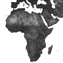
Accessibility to Cities 2015
Auf dieser globalen Karte der Erreichbarkeit sind die Fahrtzeiten für Landfahrzeuge zum nächstgelegenen dicht besiedelten Gebiet für alle Gebiete zwischen 85 Grad nördlicher und 60 Grad südlicher Breite für das Jahr 2015 aufgeführt. Dicht besiedelte Gebiete sind zusammenhängende Gebiete mit mindestens 1.500 Einwohnern pro Quadratkilometer oder … barrierefreiheit jrc karte oxford bevölkerung twente -
Accessibility to Healthcare 2019
Auf dieser globalen Karte zur Erreichbarkeit sind die Fahrtzeiten (in Minuten) zu Fuß oder mit dem Auto zum nächstgelegenen Krankenhaus oder zur nächstgelegenen Klinik für alle Gebiete zwischen 85 Grad nördlicher und 60 Grad südlicher Breite für das Jahr 2019 aufgeführt. Außerdem ist die reine Gehzeit enthalten, wenn nur nicht motorisierte Verkehrsmittel genutzt werden. Schwerwiegend … barrierefreiheit jrc karte oxford bevölkerung twente -
Global Friction Surface 2019
Diese globale Reibungsfläche gibt die Geschwindigkeit für Landreisen für alle Landpixel zwischen 85 Grad nördlicher und 60 Grad südlicher Breite für das Jahr 2019 an. Außerdem wird die Reisegeschwindigkeit für Fußgänger berücksichtigt, die nur zu Fuß oder mit nicht motorisierten Verkehrsmitteln zurückgelegt wird. Diese Karte wurde in Zusammenarbeit mit … barrierefreiheit jrc karte oxford bevölkerung twente
Datasets tagged accessibility in Earth Engine
[null,null,[],[[["\u003cp\u003eThe datasets provide global accessibility maps detailing travel time to cities, healthcare facilities, and overall land-based travel speed.\u003c/p\u003e\n"],["\u003cp\u003eThese maps cover land areas between 85 degrees north and 60 degrees south for the years 2015 (cities), 2019 (healthcare and travel speed).\u003c/p\u003e\n"],["\u003cp\u003eData includes travel time estimations for both motorized and non-motorized (walking-only) transportation.\u003c/p\u003e\n"],["\u003cp\u003eThe maps were developed through a collaboration between the University of Oxford, Google, the Joint Research Centre of the European Commission, and the University of Twente.\u003c/p\u003e\n"]]],["The data provides global land-based travel information between 85°N and 60°S. It details travel time to the nearest densely populated area (1,500+ inhabitants/km²) for 2015 and to healthcare facilities for 2019. It also includes a 2019 global friction surface map showing travel speed, including non-motorized options. The datasets are products of a collaboration and cover aspects of accessibility to cities, healthcare, and overall travel conditions.\n"],null,["# Datasets tagged accessibility in Earth Engine\n\n-\n\n |---------------------------------------------------------------------------------------------------------------------------------------------------------------------------------------------------------------------------------------------------------------------------------------------------------------|\n | [### Accessibility to Cities 2015](/earth-engine/datasets/catalog/Oxford_MAP_accessibility_to_cities_2015_v1_0) |\n | This global accessibility map enumerates land-based travel time to the nearest densely-populated area for all areas between 85 degrees north and 60 degrees south for a nominal year 2015. Densely-populated areas are defined as contiguous areas with 1,500 or more inhabitants per square kilometer or ... |\n | [accessibility](/earth-engine/datasets/tags/accessibility) [jrc](/earth-engine/datasets/tags/jrc) [map](/earth-engine/datasets/tags/map) [oxford](/earth-engine/datasets/tags/oxford) [population](/earth-engine/datasets/tags/population) [twente](/earth-engine/datasets/tags/twente) |\n\n-\n\n |--------------------------------------------------------------------------------------------------------------------------------------------------------------------------------------------------------------------------------------------------------------------------------------------------------------|\n | [### Accessibility to Healthcare 2019](/earth-engine/datasets/catalog/Oxford_MAP_accessibility_to_healthcare_2019) |\n | This global accessibility map enumerates land-based travel time (in minutes) to the nearest hospital or clinic for all areas between 85 degrees north and 60 degrees south for a nominal year 2019. It also includes \"walking-only\" travel time, using non-motorized means of transportation only. Major ... |\n | [accessibility](/earth-engine/datasets/tags/accessibility) [jrc](/earth-engine/datasets/tags/jrc) [map](/earth-engine/datasets/tags/map) [oxford](/earth-engine/datasets/tags/oxford) [population](/earth-engine/datasets/tags/population) [twente](/earth-engine/datasets/tags/twente) |\n\n-\n\n |----------------------------------------------------------------------------------------------------------------------------------------------------------------------------------------------------------------------------------------------------------------------------------------------------------------------|\n | [### Global Friction Surface 2019](/earth-engine/datasets/catalog/Oxford_MAP_friction_surface_2019) |\n | This global friction surface enumerates land-based travel speed for all land pixels between 85 degrees north and 60 degrees south for a nominal year 2019. It also includes \"walking-only\" travel speed, using non-motorized means of transportation only. This map was produced through a collaboration between ... |\n | [accessibility](/earth-engine/datasets/tags/accessibility) [jrc](/earth-engine/datasets/tags/jrc) [map](/earth-engine/datasets/tags/map) [oxford](/earth-engine/datasets/tags/oxford) [population](/earth-engine/datasets/tags/population) [twente](/earth-engine/datasets/tags/twente) |"]]