- Kataloginhaber
- Global Pasture Watch
- Dataset-Verfügbarkeit
- 2000-01-01T00:00:00Z–2024-01-01T00:00:00Z
- Dataset-Anbieter
- Land and Carbon Lab Global Pasture Watch
- Kontakt
- Land & Carbon Lab
- Intervall
- 1 Jahr
- Tags
Beschreibung
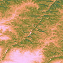
Dieser Datensatz enthält globale, nicht kalibrierte, EO-basierte Daten zur Bruttoprimärproduktion ab dem Jahr 2000 mit einer räumlichen Auflösung von 30 m. Der aktuelle Datensatz wurde von der Initiative „Global Pasture Watch“ des Land & Carbon Lab erstellt und bietet Werte für die Brutto-Primärproduktivität (Gross Primary Productivity, GPP) weltweit mit einer räumlichen Auflösung von 30 m ab dem Jahr 2000. GPP-Werte werden mit einem LUE-Ansatz (Light Use Efficiency) modelliert, wobei GLAD Landsat ARD (Collection 2) alle zwei Monate aggregiert werden (Consoli et al., 2024) und mit MODIS-Temperaturdaten mit einer Auflösung von 1 km und CERES-Daten zur photosynthetisch aktiven Strahlung (PAR) mit einer Auflösung von 1° kombiniert.
Um den Datensatz flexibel zu halten, wird die maximale Lichtnutzungseffizienz (LUEmax) für alle Landbedeckungstypen auf 1 gC/m²/Tag/MJ festgelegt. So können die Nutzer die GPP-Werte später an bestimmte Landbedeckungskarten oder regionale Bedingungen anpassen.
Die zweimonatlichen unkalibrierten Werte für die Bruttoprimärproduktion (uGPP) (verfügbar in OpenLandMap STAC) werden für jedes Jahr gemittelt und über den gesamten Zeitraum von 365 Tagen summiert, um globale jährliche uGPP-Werte in gC/m²/Jahr zu erhalten.
Die Werte für die Brutto-Primärproduktion von Grasland werden mit der GEE-App on-the-fly berechnet.
Beschränkungen:
Fehlerhafte Auflösung der Eingabedaten: Der Datensatz wird mit einer Auflösung von 30 m bereitgestellt, aber wichtige Eingabevariablen für die Temperatur (MOD11A1) und die photosynthetisch aktive Strahlung (CERES PAR) wurden aus viel gröberen Produkten abgeleitet (1 km bzw. ~111 km). Die Herunterskalierung dieser Informationen kann zu Unsicherheiten führen und möglicherweise keine kleinskaligen mikroklimatischen Bedingungen erfassen, die sich auf die Pflanzenproduktivität auswirken.
Datenartefakte: Das Dataset enthält bekannte visuelle Artefakte, darunter vertikale Streifen („Streifeneffekt“) in einigen Bereichen, die auf Probleme mit dem Landsat 7-Sensor (Ausfall des Scan Line Corrector) und dem anschließenden Verfahren zur Lückenfüllung zurückzuführen sind, das zum Erstellen des zugrunde liegenden Reflektanzarchivs verwendet wurde (Consoli et al., 2024). Diese Artefakte können die räumliche Kontinuität von GPP-Schätzungen während bewölkter und schneebedeckter Perioden stören.
Zeitliche Auflösung: Die Daten werden mit einer zweimonatlichen zeitlichen Auflösung erstellt. Dieser Zeitraum reicht möglicherweise nicht aus, um wichtige Wachstumsphasen oder die schnellen Reaktionen einer Pflanze (starker Regen) auf Umweltveränderungen zu erfassen. Daher ist es schwierig, Produktivitätsspitzen und saisonale Schwankungen genau zu erfassen.
Kalibrierung von Grasland: Die GPP-Werte für Grasland werden anhand eines einzelnen Parameters für die maximale Lichtnutzungseffizienz (LUEmax) (0, 86 gC/m²/Jahr/MJ) für alle globalen Graslandflächen auf Grundlage des MOD17-Algorithmus berechnet. Dieser Wert ist nicht für bestimmte Graslandtypen oder lokale Bedingungen optimiert. Daher neigt das Modell dazu, die GPP im Vergleich zu bodenbasierten Flux-Tower-Messungen zu unterschätzen.
Abhängigkeit von der Genauigkeit der Grünlandkarten: Die Genauigkeit der GPP-Werte für Grünland hängt von der Genauigkeit der zugrunde liegenden GPW-Grünlandkarten ab. Eine falsche Klassifizierung der Landbedeckung in den Quellkarten (z.B. wenn Strauchland oder Ackerland als Grasland identifiziert wird) führt zu entsprechenden Fehlern in den GPP-Schätzungen für diese Standorte.
Weitere Informationen finden Sie unter Isik et al., 2025, Zenodo und Global Pasture Watch GitHub-Website.
Bänder
Bänder
| Name | Min. | Max. | Pixelgröße | Beschreibung |
|---|---|---|---|---|
gc_m2 |
0 | 4000 | 30 Meter | Gramm Kohlenstoff pro Quadratmeter pro Jahr (gC/m²/Jahr) |
Bildattribute
Bildattribute
| Name | Typ | Beschreibung |
|---|---|---|
| Version | INT | Produktversion |
Nutzungsbedingungen
Nutzungsbedingungen
Zitate
Isik, M. S., Mesquita, V., Parente, L., & Consoli, D. (2025). Global Pasture Watch – Quellcode der globalen, nicht kalibrierten, EO-basierten GPP- und Grasland-GPP-Karten mit einer Auflösung von 30 m. Zenodo. [Quellcode] Zenodo doi:https://doi.org/10.5281/zenodo.15675358
Isik MS, Parente L, Consoli D, et al. (2025). Bimonatliche Brutto-Primärproduktivität (GPP) basierend auf der Lichtnutzungseffizienz (LUE) für globales Grünland mit einer räumlichen Auflösung von 30 m (2000–2022), PeerJ. doi: https://doi.org/10.7717/peerj.19774
DOIs
Earth Engine nutzen
Code-Editor (JavaScript)
Map.setCenter(-49.265188, -16.602052, 4);

var ugppVis = {min: 0, max: 4000, palette: "faccfa,f19d6b,828232,226061,011959"}
var ugpp = ee.ImageCollection(
    "projects/global-pasture-watch/assets/ggpp-30m/v1/ugpp_m"
)

var ugpp2024 = ugpp.filterDate('2024-01-01', '2025-01-01').first();
Map.addLayer(ugpp2024, ugppVis, 'Uncalibrated GPP (2024)');

var ugpp2000 = ugpp.filterDate('2000-01-01', '2001-01-01').first();
Map.addLayer(ugpp2000, ugppVis, 'Uncalibrated GPP (2000)');