Ежегодная площадь мангровых лесов в мире (1984-2023 гг.) 
Набор данных CGMD-Extent30 (Continuous Global Mangrove Dynamics-Annual Mangrove Extent at 30-m resolution) предоставляет данные о ежегодной площади мангровых зарослей в мире с 1984 по 2023 год. Набор данных распространяется в виде единой коллекции объектов Earth Engine FeatureCollection, где каждый объект представляет собой отображенный полигон мангровых зарослей за конкретный год. Набор данных… ежегодная биомасса прибрежных лесов, полученная на основе глобальных данных Landsat, землепользование и земельный покров Глобальная годовая доля площади, покрывающей мангровые заросли (1984-2023 гг.) 
Этот набор данных предоставляет глобальные ежегодные данные о доле растительного покрова мангровых лесов (FCC) с пространственным разрешением 30 м за период с 1984 по 2023 год для поддержки крупномасштабного анализа долгосрочной динамики мангровых лесов, включая деградацию и восстановление растительного покрова, оценку «голубого углерода» и мониторинг прибрежных экосистем. FCC количественно определяет долю каждого спутника Landsat… ежегодная биомасса прибрежных лесов, полученная с помощью глобальных спутниковых снимков мангровых зарослей Глобальное распространение мангровых лесов, т. 1 (2000) 
База данных была подготовлена с использованием спутниковых данных Landsat за 2000 год. Более 1000 снимков Landsat, полученных из Центра наблюдения и изучения земных ресурсов Геологической службы США (EROS), были классифицированы с использованием гибридных методов цифровой классификации изображений с обучением и без обучения. Эта база данных является первой и наиболее… ежегодный циезин лесная биомасса глобальные данные Landsat мангровые леса История классификации водных ресурсов JRC за год, версия 1.4 
Этот набор данных содержит карты расположения и временного распределения поверхностных вод с 1984 по 2021 год, а также статистические данные о масштабах и изменениях этих водных поверхностей. Более подробную информацию можно найти в соответствующей журнальной статье: Высокоточное картирование глобальных поверхностных вод и их… ежегодная геофизическая история Google JRC данные Landsat MOD44B.061 Терра Растительность Непрерывные Поля Ежегодно Глобальный 250 м 
Продукт Terra MODIS Vegetation Continuous Fields (VCF) представляет собой субпиксельное отображение оценок растительного покрова поверхности Земли в глобальном масштабе. Разработанный для непрерывного представления земной поверхности в виде доли основных характеристик растительности, он обеспечивает градацию трех компонентов растительного покрова: процент древесного покрова, процент… ежегодное геофизическое глобальное землепользование-растительный покров modis nasa Open Buildings Temporal V1 
Временной набор данных Open Buildings 2.5D содержит информацию о наличии зданий, доле зданий в общей площади и высоте зданий с эффективным пространственным разрешением 4 м (растровые изображения предоставляются с разрешением 0,5 м) с ежегодной периодичностью с 2016 по 2023 год. Он создан на основе изображений низкого разрешения из открытых источников… Африка ежегодный Азия высота застройки открытые здания Встраивание спутника V1 
Набор данных Google Satellite Embedding представляет собой глобальную, готовую к анализу коллекцию обученных геопространственных векторных представлений. Каждый 10-метровый пиксель в этом наборе данных представляет собой 64-мерное представление, или «вектор встраивания», который кодирует временные траектории поверхностных условий в этом пикселе и вокруг него, измеренные с помощью различных методов дистанционного зондирования Земли… ежегодные глобальные спутниковые снимки Google , полученные с помощью Landsat, полученные с помощью Sentinel1 VIIRS Ночное время День/Ночь Ежегодные сводные данные по диапазонам частот V2.1 
Ежегодный глобальный набор данных VIIRS о ночном освещении представляет собой временной ряд, полученный из ежемесячных сеток усредненной яркости без облаков за период с 2013 по 2021 год. Данные за 2022 год доступны в наборе данных NOAA/VIIRS/DNB/ANNUAL_V22. На начальном этапе фильтрации были удалены пиксели, освещенные Солнцем, луной и облаками, что привело к получению приблизительных композитных изображений, которые… ежегодные dnb eog огни ночное время noaa VIIRS Ночное время День/Ночь Ежегодные сводные данные по диапазонам частот V2.2 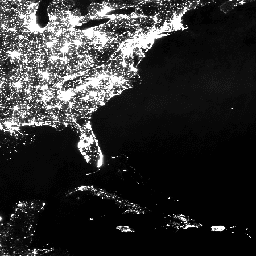
Ежегодный глобальный набор данных VIIRS о ночном освещении представляет собой временной ряд, полученный из ежемесячных сеток усредненной яркости без облаков за 2022 год. Данные за предыдущие годы доступны в наборе данных NOAA/VIIRS/DNB/ANNUAL_V21. На начальном этапе фильтрации были удалены пиксели, освещенные Солнцем, луной и облаками, что привело к получению приблизительных композитных изображений, содержащих… ежегодные dnb eog огни ночное время noaa
Datasets tagged annual in Earth Engine
[null,null,[],[],["The datasets provide annual global information on various Earth features. The Open Buildings dataset offers building presence, counts, and heights from 2016-2023. JRC data maps surface water distribution and changes from 1984-2021. Another dataset, based on data from 2000, details mangrove forest distribution. MODIS data provides continuous vegetation cover estimates, including tree cover percentages. Lastly, VIIRS data sets map annual nighttime light composites from 2013-2022, based on cloud-free average radiance grids.\n"]]