-
MTBS Yanan Alan Sınırları

Yangın Şiddetindeki Eğilimleri İzleme (MTBS) yanmış alan sınırları veri kümesi; kıtasal ABD, Alaska, Hawaii ve Porto Riko'daki tüm MTBS yangınlarının yanmış alanlarının kapsam poligonlarını içerir. NBR'nin altında "Normalleştirilmiş Yanma Oranı" anlamına gelirken dNBR ise … eros fire gtac mtbs table usda -
Yangın Şiddetindeki Trendleri İzleme (MTBS) Yangın Şiddeti Görüntüleri
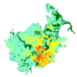
Yangın şiddeti mozaikleri; kıtasal ABD, Alaska, Hawaii ve Porto Riko'da şu anda tamamlanmış tüm MTBS yangınları için MTBS yangın şiddeti sınıflarının tematik raster görüntülerinden oluşur. Mozaiklenmiş yanma şiddeti görüntüleri, ABD eyaletlerine göre her yıl derlenir ve … eros fire forest gtac landcover landsat-derived -
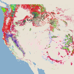
USFS Landscape Change Monitoring System v2025-11 (CONUS and OCONUS)

Bu ürün, Landscape Change Monitoring System (LCMS) veri paketinin bir parçasıdır. Her yıl için LCMS ile modellenmiş değişiklikleri, arazi örtüsünü ve/veya arazi kullanım sınıflarını gösterir. Ayrıca, Alaska (AK), Porto Riko (PR) ve Hawaii (HI) dahil olmak üzere ABD'nin bitişik eyaletlerinin (CONUS) yanı sıra CONUS dışındaki alanları (OCONUS) kapsar. change-detection forest gtac landcover landuse landuse-landcover -
USFS Tree Canopy Cover v2023-5 (CONUS ve OCONUS)
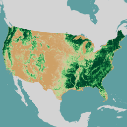
Genel bakış ABD Tarım Bakanlığı, Orman Hizmetleri (USFS) tarafından üretilen Ağaç Örtüsü Alanları (TCC) veri paketi, 1985-2023 yılları arasındaki yıllık uzaktan algılamaya dayalı harita çıktılarını içerir. Bu veriler, ABD Jeoloji Araştırmaları Kurumu tarafından yönetilen Ulusal Arazi Örtüsü Veritabanı (NLCD) projesini destekler. forest gtac landuse-landcover redcastle-resources usda usfs -
USFS TreeMap v2016 (Conterminous United States)

Bu ürün, TreeMap veri paketinin bir parçasıdır. 2016'da ABD'nin kıta kısmındaki tüm ormanlık alanlarda canlı ve ölü ağaç sayısı, biyokütle ve karbon gibi orman özellikleriyle ilgili ayrıntılı mekansal bilgiler sağlar. TreeMap v2016, bir resim, bir … biyokütle karbon iklim değişikliği conus orman orman biyokütlesi -
USFS TreeMap v2020

Bu ürün, TreeMap veri paketinin bir parçasıdır. 2020'de ABD'nin ormanlık alanının tamamında canlı ve ölü ağaç sayısı, biyokütle ve karbon gibi orman özellikleriyle ilgili ayrıntılı uzamsal bilgiler sağlar. TreeMap v2020, 22 bantlı 30 x 30 m … aboveground biomass carbon climate-change conus forest -
USFS TreeMap v2022
Bu ürün, TreeMap veri paketinin bir parçasıdır. 2022'de ABD'nin ormanlık alanlarının tamamındaki canlı ve ölü ağaç sayısı, biyokütle ve karbon gibi orman özellikleriyle ilgili ayrıntılı mekansal bilgiler sağlar. TreeMap v2022, 22 bantlı 30 x 30 m … aboveground biomass carbon climate-change conus forest
Datasets tagged usfs in Earth Engine
[null,null,[],[],[]]