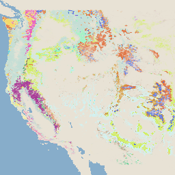
-
Monitorowanie trendów w zakresie wagi spalania (MTBS) – obrazy dotyczące wagi spalania
Mozaiki dotyczące stopnia intensywności pożaru obejmują tematyczne obrazy rastrowe klasyfikacji intensywności pożaru według MTBS dla wszystkich pożarów MTBS, które zostały już ugaszone na kontynentalnych Stanach Zjednoczonych, Alasce, Hawajach i w Portoryko. Obrazy z mozaiką obrazów obrazujących stopień poparzenia są roczne i sporządzane przez stany USA oraz … eros fire forest gtac landcover landsat-derived -
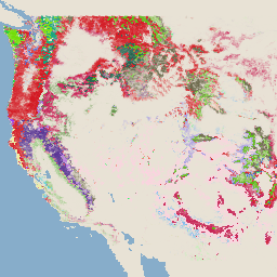
System monitorowania zmian w krajobrazie USFS w wersji 2024.10 (CONUS i OCONUS)
Ta usługa należy do zestawu danych systemu monitorowania zmian w krajobrazie (LCMS). Pokazuje ona zmiany modelowane przez LCMS, pokrycie terenu i klasy użytkowania gruntów w poszczególnych latach. Obejmuje ona kontynentalną część Stanów Zjednoczonych (CONUS) oraz obszary poza CONUS, w tym Alaskę (AK), Portoryko … change-detection forest gtac landcover landuse landuse-landcover -
USFS Tree Canopy Cover v2023-5 (CONUS and OCONUS)
Ta usługa należy do pakietu danych o zagęszczeniu drzew. Zawiera on modelowany TCC, błąd standardowy (SE) i dane TCC z National Land Cover Database (NLCD) dla każdego roku. Dane TCC opracowane przez United States Department of Agriculture, Forest Service (USFS) są … forest gtac landuse-landcover redcastle-resources usda usfs -
USFS TreeMap v2016 (Conterminous United States)
Ta usługa jest częścią pakietu danych TreeMap. Zawiera on szczegółowe informacje przestrzenne o charakterystyce lasów, w tym liczbę żywych i martwych drzew, biomasę oraz ilość węgla w całym obszarze porośniętym lasem w Stanach Zjednoczonych w 2016 r. TreeMap v2016 zawiera 1 obraz, … biomass carbon climate-change conus forest forest-biomass
Datasets tagged redcastle-resources in Earth Engine
[null,null,[],[[["\u003cp\u003eThe MTBS dataset provides annual burn severity mosaics for fires across the US, including Alaska, Hawaii, and Puerto Rico.\u003c/p\u003e\n"],["\u003cp\u003eThe USFS TreeMap v2016 dataset offers detailed forest characteristic information for the continental United States, including tree counts, biomass, and carbon estimates.\u003c/p\u003e\n"],["\u003cp\u003eThe USFS Tree Canopy Cover v2021-4 dataset includes modeled and NLCD tree canopy cover data, along with standard error, for the continental US and other US territories.\u003c/p\u003e\n"]]],[],null,["# Datasets tagged redcastle-resources in Earth Engine\n\n-\n\n |------------------------------------------------------------------------------------------------------------------------------------------------------------------------------------------------------------------------------------------------------------------------------------------------|\n | [### Monitoring Trends in Burn Severity (MTBS) Burn Severity Images](/earth-engine/datasets/catalog/USFS_GTAC_MTBS_annual_burn_severity_mosaics_v1) |\n | The burn severity mosaics consist of thematic raster images of MTBS burn severity classes for all currently completed MTBS fires for the continental United States, Alaska, Hawaii and Puerto Rico. Mosaicked burn severity images are compiled annually for each year by US State and the ... |\n | [eros](/earth-engine/datasets/tags/eros) [fire](/earth-engine/datasets/tags/fire) [forest](/earth-engine/datasets/tags/forest) [gtac](/earth-engine/datasets/tags/gtac) [landcover](/earth-engine/datasets/tags/landcover) [landsat-derived](/earth-engine/datasets/tags/landsat-derived) |\n\n-\n\n |-----------------------------------------------------------------------------------------------------------------------------------------------------------------------------------------------------------------------------------------------------------------------------------------------------------------------------|\n | [### USFS Landscape Change Monitoring System v2024.10 (CONUS and OCONUS)](/earth-engine/datasets/catalog/USFS_GTAC_LCMS_v2024-10) |\n | This product is part of the Landscape Change Monitoring System (LCMS) data suite. It shows LCMS-modeled change, land cover, and/or land use classes for each year and covers the Conterminous United States (CONUS) as well as areas outside the CONUS (OCONUS) including Alaska (AK), Puerto ... |\n | [change-detection](/earth-engine/datasets/tags/change-detection) [forest](/earth-engine/datasets/tags/forest) [gtac](/earth-engine/datasets/tags/gtac) [landcover](/earth-engine/datasets/tags/landcover) [landuse](/earth-engine/datasets/tags/landuse) [landuse-landcover](/earth-engine/datasets/tags/landuse-landcover) |\n\n-\n\n |-------------------------------------------------------------------------------------------------------------------------------------------------------------------------------------------------------------------------------------------------------------------------------------------------------------------|\n | [### USFS Tree Canopy Cover v2023-5 (CONUS and OCONUS)](/earth-engine/datasets/catalog/USGS_NLCD_RELEASES_2023_REL_TCC_v2023-5) |\n | This product is part of the Tree Canopy Cover (TCC) data suite. It includes modeled TCC, standard error (SE), and National Land Cover Database's (NLCD) TCC data for each year. TCC data produced by the the United States Department of Agriculture, Forest Service (USFS) are ... |\n | [forest](/earth-engine/datasets/tags/forest) [gtac](/earth-engine/datasets/tags/gtac) [landuse-landcover](/earth-engine/datasets/tags/landuse-landcover) [redcastle-resources](/earth-engine/datasets/tags/redcastle-resources) [usda](/earth-engine/datasets/tags/usda) [usfs](/earth-engine/datasets/tags/usfs) |\n\n-\n\n |---------------------------------------------------------------------------------------------------------------------------------------------------------------------------------------------------------------------------------------------------------------------------------------------------------------|\n | [### USFS TreeMap v2016 (Conterminous United States)](/earth-engine/datasets/catalog/USFS_GTAC_TreeMap_v2016) |\n | This product is part of the TreeMap data suite. It provides detailed spatial information on forest characteristics including number of live and dead trees, biomass, and carbon across the entire forested extent of the continental United States in 2016. TreeMap v2016 contains one image, a ... |\n | [biomass](/earth-engine/datasets/tags/biomass) [carbon](/earth-engine/datasets/tags/carbon) [climate-change](/earth-engine/datasets/tags/climate-change) [conus](/earth-engine/datasets/tags/conus) [forest](/earth-engine/datasets/tags/forest) [forest-biomass](/earth-engine/datasets/tags/forest-biomass) |\n\n-\n\n |---------------------------------------------------------------------------------------------------------------------------------------------------------------------------------------------------------------------------------------------------------------------------------------------------------|\n | [### USFS TreeMap v2020](/earth-engine/datasets/catalog/USFS_GTAC_TreeMap_v2020) |\n | This product is part of the TreeMap data suite. It provides detailed spatial information on forest characteristics including number of live and dead trees, biomass, and carbon across the entire forested extent of the United States in 2020. TreeMap v2020 contains 22-band 30 x 30m ... |\n | [aboveground](/earth-engine/datasets/tags/aboveground) [biomass](/earth-engine/datasets/tags/biomass) [carbon](/earth-engine/datasets/tags/carbon) [climate-change](/earth-engine/datasets/tags/climate-change) [conus](/earth-engine/datasets/tags/conus) [forest](/earth-engine/datasets/tags/forest) |\n\n-\n\n |---------------------------------------------------------------------------------------------------------------------------------------------------------------------------------------------------------------------------------------------------------------------------------------------------------|\n | [### USFS TreeMap v2022](/earth-engine/datasets/catalog/USFS_GTAC_TreeMap_v2022) |\n | This product is part of the TreeMap data suite. It provides detailed spatial information on forest characteristics including number of live and dead trees, biomass, and carbon across the entire forested extent of the United States in 2022. TreeMap v2022 contains 22-band 30 x 30m ... |\n | [aboveground](/earth-engine/datasets/tags/aboveground) [biomass](/earth-engine/datasets/tags/biomass) [carbon](/earth-engine/datasets/tags/carbon) [climate-change](/earth-engine/datasets/tags/climate-change) [conus](/earth-engine/datasets/tags/conus) [forest](/earth-engine/datasets/tags/forest) |"]]