-
Granice spalonych obszarów MTBS
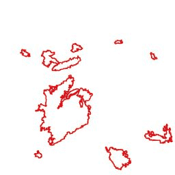
Zbiór danych o granicach spalonych obszarów MTBS (Monitoring Trends in Burn Severity) zawiera wielokąty przedstawiające zasięg spalonych obszarów wszystkich obecnie ukończonych pożarów MTBS na terenie kontynentalnej części Stanów Zjednoczonych, Alaski, Hawajów i Portoryko. Poniżej NBR oznacza „Normalized Burn Ratio” (znormalizowany współczynnik spalenia), a dNBR oznacza… eros fire gtac mtbs table usda -
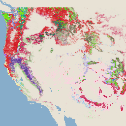
Obrazy przedstawiające stopień spalenia MTBS (Monitoring Trends in Burn Severity)

Mozaiki stopnia spalenia składają się z tematycznych obrazów rastrowych klas stopnia spalenia MTBS dla wszystkich obecnie ukończonych pożarów MTBS na terenie kontynentalnej części Stanów Zjednoczonych, Alaski, Hawajów i Portoryko. Mozaiki obrazów stopnia spalenia są tworzone co roku dla każdego stanu USA i… eros fire forest gtac landcover landsat-derived -
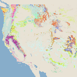
System monitorowania zmian krajobrazu USFS w wersji 2025-11 (CONUS i OCONUS)

Ten produkt jest częścią pakietu danych systemu monitorowania zmian krajobrazu (LCMS). Pokazuje zmiany modelowane przez LCMS, pokrycie terenu i/lub klasy użytkowania terenu dla każdego roku i obejmuje kontynentalną część Stanów Zjednoczonych (CONUS) oraz obszary poza CONUS (OCONUS), w tym Alaskę (AK), Portoryko… change-detection forest gtac landcover landuse landuse-landcover -
Pokrycie koron drzew USFS w wersji 2023-5 (CONUS i OCONUS)
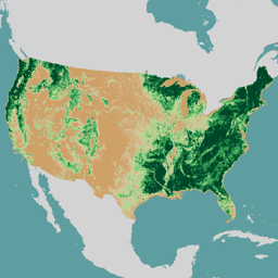
Omówienie Pakiet danych dotyczących pokrycia koron drzew (TCC) opracowany przez Służbę Leśną Departamentu Rolnictwa Stanów Zjednoczonych (USFS) to roczne mapy oparte na teledetekcji obejmujące okres od 1985 do 2023 roku. Te dane wspierają projekt National Land Cover Database (NLCD), którym zarządza US Geological… forest gtac landuse-landcover redcastle-resources usda usfs -
TreeMap USFS w wersji 2016 (kontynentalna część Stanów Zjednoczonych)
Ten produkt jest częścią pakietu danych TreeMap. Zawiera szczegółowe informacje przestrzenne o charakterystyce lasów, w tym o liczbie żywych i martwych drzew, biomasie i dwutlenku węgla na całym zalesionym obszarze kontynentalnej części Stanów Zjednoczonych w 2016 roku. TreeMap w wersji 2016 zawiera 1 obraz,… biomass carbon climate-change conus forest forest-biomass -
TreeMap USFS w wersji 2020
Ten produkt jest częścią pakietu danych TreeMap. Zawiera szczegółowe informacje przestrzenne o charakterystyce lasów, w tym o liczbie żywych i martwych drzew, biomasie i węglu na całym zalesionym obszarze Stanów Zjednoczonych w 2020 roku. TreeMap w wersji 2020 zawiera 22-pasmowy obraz o rozdzielczości 30 x 30 m… aboveground biomass carbon climate-change conus forest -
TreeMap USFS w wersji 2022

Ten produkt jest częścią pakietu danych TreeMap. Zawiera szczegółowe informacje przestrzenne o charakterystyce lasów, w tym o liczbie żywych i martwych drzew, biomasie i węglu na całym zalesionym obszarze Stanów Zjednoczonych w 2022 roku. TreeMap w wersji 2022 zawiera 22-pasmowy obraz o rozdzielczości 30 x 30 m… aboveground biomass carbon climate-change conus forest
Datasets tagged usfs in Earth Engine
[null,null,[],[],[]]