Bạn có thể đặt độ cao của một điểm đánh dấu bằng cách đặt thuộc tính altitudeMode thành một trong các giá trị sau:
ABSOLUTE
RELATIVE_TO_GROUND
CLAMP_TO_GROUND
RELATIVE_TO_MESH
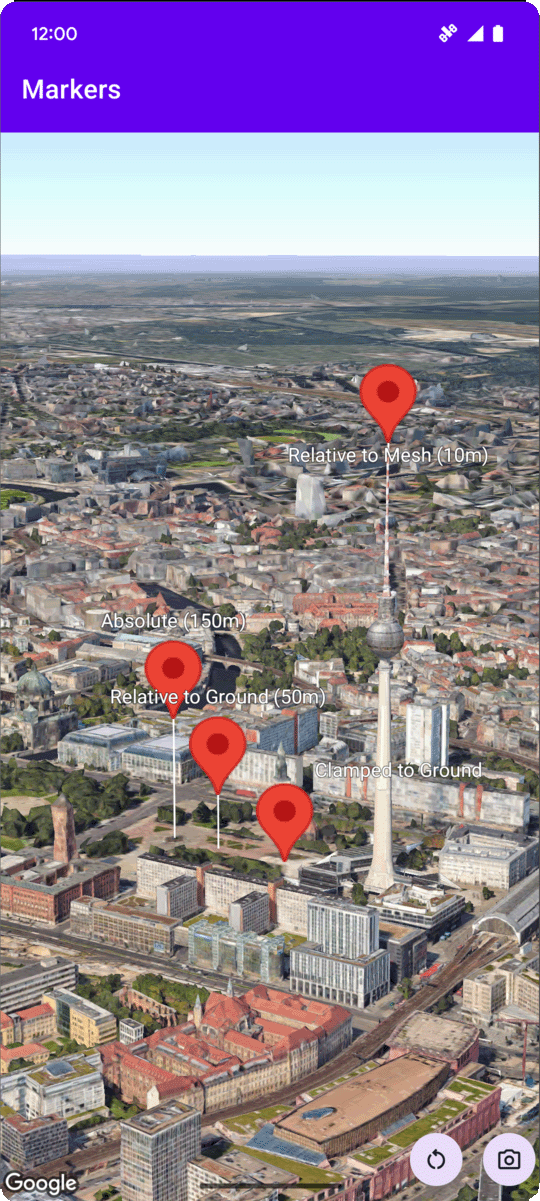
Mã mẫu sau đây minh hoạ cách sử dụng từng phương thức. Để sử dụng mã mẫu này, hãy làm theo hướng dẫn trong phần Thiết lập và Thêm bản đồ 3D vào ứng dụng để thiết lập dự án Android Studio bằng một bản đồ 3D cơ bản. Sau đó, hãy thêm đoạn mã sau vào tệp MainActivity.kt:
// Add importsimportcom.google.android.gms.maps3d.model.latLngAltitude...// Add to the onMap3DViewReady method, after the googleMap3D object has been initializedgoogleMap3D.setMapMode(Map3DMode.SATELLITE)googleMap3D.setCamera(camera{center=latLngAltitude{latitude=52.51974795longitude=13.40715553altitude=150.0}heading=252.7tilt=79.0range=1500.0})// Marker 1: AbsolutegoogleMap3D.addMarker(markerOptions{position=latLngAltitude{latitude=52.519605780912585longitude=13.406867190588198altitude=150.0}label="Absolute (150m)"altitudeMode=AltitudeMode.ABSOLUTEisExtruded=trueisDrawnWhenOccluded=truecollisionBehavior=CollisionBehavior.REQUIRED_AND_HIDES_OPTIONAL})// Marker 2: Relative to GroundgoogleMap3D.addMarker(markerOptions{position=latLngAltitude{latitude=52.519882191069016longitude=13.407410777254293altitude=50.0}label="Relative to Ground (50m)"altitudeMode=AltitudeMode.RELATIVE_TO_GROUNDisExtruded=trueisDrawnWhenOccluded=true})// Marker 3: Clamped to GroundgoogleMap3D.addMarker(markerOptions{position=latLngAltitude{latitude=52.52027645136134longitude=13.408271658592406altitude=0.0// altitude is effectively ignored by CLAMP_TO_GROUND for rendering,// but might be relevant if you read the marker's position later.// For CLAMP_TO_GROUND, it's often set to 0.0.}label="Clamped to Ground"altitudeMode=AltitudeMode.CLAMP_TO_GROUNDisExtruded=trueisDrawnWhenOccluded=true})// Marker 4: Relative to MeshgoogleMap3D.addMarker(markerOptions{position=latLngAltitude{latitude=52.520835071144226longitude=13.409426847943774altitude=10.0// Altitude relative to 3D mesh (buildings, terrain features)}label="Relative to Mesh (10m)"altitudeMode=AltitudeMode.RELATIVE_TO_MESHisExtruded=trueisDrawnWhenOccluded=true})
[null,null,["Cập nhật lần gần đây nhất: 2025-08-31 UTC."],[],[],null,["# Configure marker altitude\n\nSelect platform: [Android](/maps/documentation/maps-3d/android-sdk/configure-marker-altitude \"View this page for the Android platform docs.\") [iOS](/maps/documentation/maps-3d/ios-sdk/configure-marker-altitude \"View this page for the iOS platform docs.\")\n\n\u003cbr /\u003e\n\n| This product or feature is Experimental (pre-GA). Pre-GA products and features might have limited support, and changes to pre-GA products and features might not be compatible with other pre-GA versions. Pre-GA Offerings are covered by the [Google\n| Maps Platform Service Specific Terms](https://cloud.google.com/maps-platform/terms/maps-service-terms). For more information, see the [launch stage descriptions](/maps/launch-stages).\n\n\nYou can set a marker's altitude by setting the\n[`altitudeMode`](/maps/documentation/maps-3d/android-sdk/reference/com/google/android/gms/maps3d/model/MarkerOptions#altitudeMode())\nproperty to one of the\nfollowing values:\n\n- `ABSOLUTE`\n- `RELATIVE_TO_GROUND`\n- `CLAMP_TO_GROUND`\n- `RELATIVE_TO_MESH`\n\nThe following code sample\ndemonstrates how to use each of the methods. To use this code sample, follow the instructions in\n[Setup](/maps/documentation/maps-3d/android-sdk/setup) and\n[Add a 3D map to your app](/maps/documentation/maps-3d/android-sdk/add-a-3d-map) to set\nup your Android Studio project with a basic 3D map. Then, add the following code to the\n**`MainActivity.kt`** file: \n\n```kotlin\n // Add imports\n import com.google.android.gms.maps3d.model.latLngAltitude\n \n ...\n \n // Add to the onMap3DViewReady method, after the googleMap3D object has been initialized\n googleMap3D.setMapMode(Map3DMode.SATELLITE)\n \n googleMap3D.setCamera(\n camera {\n center = latLngAltitude {\n latitude = 52.51974795\n longitude = 13.40715553\n altitude = 150.0\n }\n heading = 252.7\n tilt = 79.0\n range = 1500.0\n }\n )\n \n \n // Marker 1: Absolute\n googleMap3D.addMarker(markerOptions {\n position = latLngAltitude {\n latitude = 52.519605780912585\n longitude = 13.406867190588198\n altitude = 150.0\n }\n label = \"Absolute (150m)\"\n altitudeMode = AltitudeMode.ABSOLUTE\n isExtruded = true\n isDrawnWhenOccluded = true\n collisionBehavior = CollisionBehavior.REQUIRED_AND_HIDES_OPTIONAL\n })\n \n // Marker 2: Relative to Ground\n googleMap3D.addMarker(markerOptions {\n position = latLngAltitude {\n latitude = 52.519882191069016\n longitude = 13.407410777254293\n altitude = 50.0\n }\n label = \"Relative to Ground (50m)\"\n altitudeMode = AltitudeMode.RELATIVE_TO_GROUND\n isExtruded = true\n isDrawnWhenOccluded = true\n })\n \n // Marker 3: Clamped to Ground\n googleMap3D.addMarker(markerOptions {\n position = latLngAltitude {\n latitude = 52.52027645136134\n longitude = 13.408271658592406\n altitude = 0.0 // altitude is effectively ignored by CLAMP_TO_GROUND for rendering,\n // but might be relevant if you read the marker's position later.\n // For CLAMP_TO_GROUND, it's often set to 0.0.\n }\n label = \"Clamped to Ground\"\n altitudeMode = AltitudeMode.CLAMP_TO_GROUND\n isExtruded = true\n isDrawnWhenOccluded = true\n })\n \n // Marker 4: Relative to Mesh\n googleMap3D.addMarker(markerOptions {\n position = latLngAltitude {\n latitude = 52.520835071144226\n longitude = 13.409426847943774\n altitude = 10.0 // Altitude relative to 3D mesh (buildings, terrain features)\n }\n label = \"Relative to Mesh (10m)\"\n altitudeMode = AltitudeMode.RELATIVE_TO_MESH\n isExtruded = true\n isDrawnWhenOccluded = true\n })\n \n \n```"]]